Showing posts with label Outlook. Show all posts

Friday, June 21, 2024

2024 Hurrican Season Predictions

NOAA predicts above-normal 

2024 Atlantic hurricane season


The 2024 Atlantic Hurricane Season has officially begun with the first named storm.   The National Hurricane Center is prediting above-normal season due to  La Nina and warmer-than-average ocean temperatures.

Alberto, hurricane season's first named storm, dissipates over Mexico 
 Alberto, the first named tropical storm of the Atlantic hurricane season, has dissipated after being downgraded to a tropical depression, the National Hurricane Center in Miami announced Thursday evening, but not before the storm dumped heavy rain and caused major flooding in parts of Mexico and Texas.  Torrential rains causing flooding are continuing as the storm dissipates.

Several ships operate out of Galveston, Texas so there were many eyes focased on the weather to see if there would be any disruptions. 


2024 Atlantic Hurricane Season


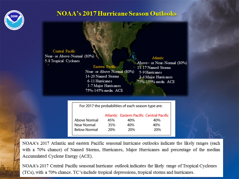
NOAA National Weather Service forecasters at the Climate Prediction Center predict above-normal hurricane activity in the Atlantic basin this year. NOAA’s outlook for the 2024 Atlantic hurricane season, which spans from June 1 to November 30, predicts an 85% chance of an above-normal season, a 10% chance of a near-normal season and a 5% chance of a below-normal season. 

NOAA is forecasting a range of 17 to 25 total named storms (winds of 39 mph or higher). Of those, 8 to 13 are forecast to become hurricanes (winds of 74 mph or higher), including 4 to 7 major hurricanes (category 3, 4 or 5; with winds of 111 mph or higher). Forecasters have a 70% confidence in these ranges.

Several factors, including near-record warm ocean temperatures in the Atlantic Ocean, development of La Nina conditions in the Pacific, reduced Atlantic trade winds and less wind shear, all of which tend to favor tropical storm formation are influcing their prediction.


Storm Names 2024


Useful Information and Links - Traveling during Hurricane Season

Cruise lines have travel apps and ask for emails and cell phone numbers for all guests.  This allows them to communicate any urgent announcements to their guests.  Be sure to provide them to your travel advisor or cruise line.   They will also update their websites and FB pages with updates that impact guests due to storms or other issues.  Some of these are always active links like the following:


Hurricane Season Dates 
Hurricane Prep Series
Read entire series (click here)


Hurricane season in the Atlantic begins June 1st and ends November 30th. The Eastern Pacific hurricane season begins May 15th and also ends November 30th.
Make a Plan (FEMA) 


More links and information about tropical storms and other weather conditions can be found in the Weather & Hurricane Zone tabs above.


If you live in, or plan to vacation in, an area where hurricanes are prevalent, please prepare in advance by reading our series.


Connect With Us On

I recently completed extensive training and have become Travel Safety Verified. As your dedicated Travel Advisor, your safety is our priority, and it's our job to ensure you have the necessary information you need to give you confidence and peace of mind when making your future travel plans. Click the link to review our Travel Safety program with valuable resources that will answer many of your questions.


Where have you explored? 

Gather your travel and food pics and join us every Wednesday  for the latest installment of #FoodTravelChat


Thursday, January 9, 2020

2019 in Review

As the year drew to a close, we took a look at some of the industry headlines and reviewed some of our cruise adventures.  Weather made the biggest headlines impacting the cruise industry in 2019.  The cruise industry responded to the hurricane devastation with outpouring of support and supplies.

Cruising continues to increase in popularity as more than 30 million guests took to the seas on a cruise vacation in 2019, according to Cruise Line Industry Association (CLIA) State of the Cruise Industry Report"While demand for cruising has reached new heights, the cruise industry is accelerating our efforts to be a leader in responsible tourism." said Kelly Craighead, CLIA President and CEO.

The cruise lines continued to add capacity,  introducing 18 new ships bringing the total to 272 CLIA-member cruise ships.


Viking Jupiter Photo Album
 "First New Cruise Ship
for 2019"


Once again honors went to Viking Ocean Cruises as it took delivery of the fourth ship in Viking Ocean's fleet, Viking Jupiter, in February. It is virtually identical to sister ships Viking Sea, Viking Sky , Viking Star  and Viking Sun, featuring 930-passenger capacity with highlights such as the Explorer Lounge, a two-deck observation library with lots of comfy chairs and couches; the Nordic-inspired spa with Finnish sauna and snow room; the indoor/outdoor Aquavit Terrace dining venue; and a magrodome pool, with a glass roof that opens in warm weather.

Viking Ocean ships are all-balcony cruise ships with the smallest cabins measuring a sizable 270 square feet; the largest suites comes in at 1,300 square feet. The ships specialize in destination-oriented cruise experiences with long days in ports, plenty of overnights in major cities and few days at sea.

Cruise fares include a selection of free shore excursions, complimentary Wi-Fi, and beer and wine at lunch and dinner offering good value for the cruise price.


Love that New Ship Smell

Our 2019 National Conference took place on Royal Caribbean Symphony of the Seas. We had our pre-cruise reception, hosted by   MSC Cruises at Hyatt Regency Miami.  MSC celebrated the launch of it's new private island in the Bahamas, Ocean Cay (watch video).

Symphony of the Seas is an Oasis-class cruise ship owned and operated by Royal Caribbean International. She is the largest passenger ship in the world by gross tonnage, at 228,021 GT, surpassing her sister Harmony of the Seas. Having our conferences on a relatively new ship, was one of our highlights for the year.

If you have specific questions about the ships, the itineraries, or cruising in general, we'd love to hear from you.
 
Weather Impact on Cruises


The damaging slow-moving storms of 2019 were Hurricane Barry (Louisiana, $600 million in damage), Hurricane Dorian (The Bahamas, Southeast U.S. and Canada, at least $4.6 billion in damage), Tropical Storm Imelda (Texas and Louisiana, $2 billion in damage), and Tropical Storm Fernand (northeast Mexico, $250 million in damage). 


Throughout September and October, we were posting itinerary updates as schedules were impacted by either the approaching storms or following the landfall.

Cruise lines rushed to aid victims with several voyages cancelled to launch rescue and supply missions.  The industry response was like no other in history.   We are proud to be part of this industry as everyone joined together to help in this time of need. 

At our conference, industry leaders from the cruise lines and organizations stressed that while there had been a tremendous response to date, it was crucial that we as Travel Professionals helped get the message out that the Bahamas & Caribbean is Open for Business.   They still need our help to recover from the hurricanes.   One of the ways this can be done is by bringing tourism dollars back into the regions hit hardest by the hurricanes.

Our Favorite Cruises for 2019

Having cruised for 30+ years, our cruise selections are driven primarily by destination and secondly by cruise ship. We love exploring new destinations from our bucket list as well as revisiting some of our favorites. Exploring new ships, including older ships we've never sailed on before, is also quite enjoyable. Of course, we love to share with our readers so that they can discover the world that awaits them.  In addition to our conference cruise on Symphony of the Seas, here were our other journeys.


13 Day Syndney Australia to New Zealand Cruise

Click on the image to the left for  Blog posts about this trip.

During our Southeast Asia Voyage we took advantage of the book onboard and anniversary sale to plan our next cruise.   New Zealand was identified as a popular destination for 2019, so in order to bring our clients first-hand experiences of this destination and the latest ship from Princess Cruises, Majestic Princess, this was the cruise we selected.   Follow along on our journey to the land down under.

Photos can be found on our Australia & New Zealand Shutterfly page


Magic Carpet

There's no shortage of innovation on Celebrity Edge. The industry-first Magic CarpetSM is both the best way to take in spectacular views and the most exciting place to be. By changing function and location, it provides an incredible array of visual perspectives and a distinct experience on every deck it visits. We particularly enjoyed having a drink while enjoying a sunset during our past cruise. 

This is only the beginning of what awaits you on Celebrity Edge. We posted on our social media accounts throughout the cruise and have begun our diary (click image).   Bookmark the page to learn more about our trip.


What's Ahead for 2020

As this is an election year in the U.S., there's a lot of uncertainty as the new year and new decade begins.   At our national conference, cruise lines execs told us that they are planning for any impact from election year by having their best deals early to fill the ships in advance of the elections.  They all told us that bookings are strong and this should be another good year for the industry.

It will be a rebuilding year for the Caribbean and Bahamas and another ship building year as well.  What will the added capacity mean?   There are still a large percentage of the population that have not experienced cruising.   The lines, including new players like Dream Cruises and Virgin Voyages, will continue to advertise which will help spread the word.

As cruise prices stabilized, many lines have been looking to onboard expenditures as a means to increase revenue.   Items that had once been included, like room service, have started to see additional charges for example.   Some passengers aren't happy with the new trend to "nickle-and-dime" them and may look to cruise lines that have less optional charges.   Luxury lines are becoming an even better value since you know your cost of the entire trip up front.

It will be interesting to see how new players, such as Viking Oceans, impacts the industry as they grow their fleets.  They are bucking the tide to go big and instead opting for smaller ships and more emphasis on the destinations.  Of course, the river cruise industry is booming as the demand soars for this method of exploring the globe. Crystal has entered the market as well, bringing another luxury option to this growing market.

Travel Professionals are not going away.  In fact, their expertise is even more valuable now, as there are more and more options to sort through.   Matching the right ship and itinerary to the cruisers' desires is one of the biggest values they bring to bear.   Hope to see you on the seven seas in 2020.

Happy New Year


@ChrisPappinMCC


Connect With Us On


Sign-up for Exclusive Email Offers


Where have you explored? 

Gather your travel and food pics and join us every Wednesday night for the latest installment of #FoodTravelChat

Tuesday, November 25, 2014

Early Bird Gets the Worm

What We Learned 
at National Conference

Times are a Changing

One of the highlights of CruiseOne / Cruises Inc. 2014 National Conference, which was held onboard Regal Princess earlier this month, was the Cruise Line Panel Q&A.  Each year, we hold our conference on a different cruise ship but no matter what line it is on, the other CLIA member cruise lines participate.

This year was no different with, representatives of many lines including Princess Cruises, Carnival Cruises, Norwegian Cruises, Royal Caribbean, Celebrity Cruises, and Holland America, to name just a few.   A subset of those lines participated in the moderated Q&A session which talked about the Cruise Industry, their business, and the outlook for next year.

Prices Are Rising 

As you might expect, the cruise lines want to sail full each sailing, so they need to monitor sales closely and adjust prices as needed.   In 2014 there was excess capacity in the Caribbean, with all the new ships, so that had pressure on pricing forcing some last minute discounting.  Cruise lines don't like to do so because it hurts their bottom line and also penalizes those that booked early.

Cruise lines are making adjustments in deployments for next year, and that over-capacity situation will not exist driving prices upwards.   Across the board the cruise lines indicated that their goal for 2015 was to have the best prices early in the sell cycle with higher prices resulting as the ships fill and demand continues.

Message to Consumers - Book Early for Best Deals

Sales for 2015 are off to a good start, so the cruise lines are confident that their strategy will work.  To be sure to keep sales on track, the lines are kicking off Wave Season early.  Normally it doesn't start until January, but many lines have already released Wave Season offers.  Wave Season is the first quarter of the year and typically has some of the best offers.   This is the time of year when people are locked inside their houses due to cold temps, so they really start to dream about getting away to somewhere warmer.
 
Of course, Black Friday is one of the biggest shopping days of the year, so cruise lines have announced offers for that as well.  See our Facebook page for some highlights.

Location, Location, Location

Besides getting the best prices by booking early, there are other advantages as well.  What would you rather look at when you wake up - 4 walls or the ocean?  Would you like the smoothest ride or is a roller-coaster cruise satisfactory?

The most important thing to having an enjoyable cruise is your accommodations.  Contrary to popular thinking, you do spend a significant amount of your vacation in your cabin, so comfortable surroundings does increase your satisfaction level.    If you've ever looked at multiple cabin categories, you'll notice that location factors into the price you pay.    Mid-ship demands a higher price tag than all the way aft or all the forward, even on the same deck.  You will find the least motion mid-ship, so anyone that might not want to feel the "motion of the ocean" should definitely try to get one of these prime cabins.

Guess which cabins sell out first?   Mid-ship and higher decks - which often mean the balconies and suites  that are highly sought after.  

Delaying your booking means you get what's left.  You'll still have a great cabin and no doubt an enjoyable cruise, but perhaps it could have been even better if you were able to get your first choice in cabins.

How to Play the Game

Our goal is to help you find the right cruise for you and your guests.  With all the added capacity, there are also many choices.   It is becoming harder for the individual to sort through all the choices and offers to find the best value for your vacation dollars.   That's where we come in - that is our task and one that we really enjoy.   We love making dreams come true and hearing about your fantastic vacation afterwards.

Our website has links to all of our various social media outlets.   Most importantly is our eNewsletter which is sent out via email on average once a week.   During Wave Season, and times when there are an abundance of offers, it might be more frequent.  Some offers cross our desk and have a very short duration - so we suggest you let us know in advance about your plans so that we can watch for the best value.


We've included links here with a brief explanation of some of the resources we offer to our followers.   Please be sure to take advantage of all these opportunities, as that is the best way to stay informed.
 
Join our eSavers

If you haven’t signed up for our eSavers Newsletter yet, be sure to do so. This is just one of our communication vehicles to keep you informed about industry news and special offers for our loyal followers.


Like Us on Facebook


Be sure to visit our Facebook Fan Page and "Like Us" so that you can be in the inner circle of our Fans. You’ll have the opportunity to be the first to know about specials and other exclusive information, such as updates from cruise lines.

@ChrisPappinMCC

Follow us on Twitter: @ChrisPappinMCC  Pinterest: CruiseWithChris Pappin and Facebook: CruiseWithChris Pappin Cruises Inc for more ideas.

Each week we post images from our trips and participate in several travel chats on Twitter.

Take advantage of these resources to assist you in planning your dream vacations.  Of course, we are always available to answer any questions you might have about travel and the industry.

Friday, September 6, 2013

Special Tropical Outlook Published for Atlantic


Heavy Rainfall for Parts of Mexico 

1130 AM EDT FRI SEP 6 2013 
FOR THE NORTH ATLANTIC...CARIBBEAN SEA AND THE GULF OF MEXICO... 
SPECIAL OUTLOOK ISSUED TO PROVIDE UPDATE 
ON THE SYSTEM IN THE GULF OF MEXICO. 

GULF OF MEXICO

We have entered into the most active time of the 2013 Atlantic Hurricane Season and the image above reflects several potential storms that are being tracked today by the National Hurricane Center in Miami, Florida. The yellow color indicates that none of the storms have a high risk of developing into tropical cyclones in the next 48 hours, but that doesn't mean that there won't be associated weather (eg. heavy rains) in the area of the developing storms.

In particular,  the low pressure area near Tampico Mexico is expected to move inland before becoming a tropical cyclone, but it is likely to bring 3 to 5 inches of rainfall and as much as 8 inches in the Mexican states of Veracruz and Tamaulipas during the next few days.   Heavy winds, near tropical storm strength, are also expected which means that the area should be prepared to take appropriate actions just as they would if the tropical storm had already formed.

See: Tropical Depression Eight in Gulf of Mexico

REMNANTS of GABRIELLE

Unfavorable conditions are preventing the further development of the remnants from Tropical Storm Gabrielle, but that doesn't mean that development is completely out of the question.  Once the storm moves further northwestward, over open Atlantic waters, it could redevelop as it heads towards Bermuda.

OTHER DEVELOPMENT

This time of year, storms near Cape Verde Islands are pretty common and often those storms are the ones that make landfall in the U.S. on the east coast.   There is a low pressure system in the area, but there isn't an immediate risk of the storm becoming a tropical cyclone.

Click on the link above for the complete text of the Special Bulletin.

Sunday, May 26, 2013

NOAA 2013 Hurricane Season Predictions

Hurricane Isaac, August 28, 2012/NOAA
Predictions for 2013 Hurricane Season

We've already provided you with NOAA's Central Pacific Hurricane Prediction as well as Colorado State University's April Prediction for the Atlantic Basin.  NOAA has just released its predictions for the Atlantic Basin and East Pacific region.


Looking Back and Looking Ahead
Hurricane Season Approaching 
ACTIVE ATLANTIC PREDICTED

NOAA's Climate Prediction Center (CPC) had predicted an active season and that turned out to be the case. The image above, courtesy of National Oceanic and Atmospheric Administration (NOAA)'s National Hurricane Center (NHC), was from Hurricane Isaac which made landfall in Louisiana battering the region. It was one of the most destructive and disruptive storms of the 2012 Hurricane Season. On the 7th Anniversary of Hurricane Katrina, Louisiana had another direct hit: Tale of Two Hurricanes Seven Years Apart.

Looking Back at 2012

In the chart below, the numbers in parenthesis are the averages, so you can easily see that the 2012 Atlantic Hurricane Season was above average.   This year marks the thirteenth above-normal season since the current high activity era for Atlantic hurricanes began in 1995.

Atlantic Basin
Forecast Parameter and 1950-2000
Climatology (in parentheses)
NOAA 2012
May Prediction
2012
Actual Results
Named Storms (NS) (9.6)  9-15 19
Hurricanes (H) (5.9)4-810
Major Hurricanes (MH) (2.3) 1-3
2
Accumulated Cyclone Energy (ACE) (96.1) 64-140 144
Note:  NOAA issued an updated prediction in August 2012:

For more details, read the complete NOAA 2012 Atlantic Seasonal Climate Summary


Atlantic Hurricane Outlook & Seasonal Climate Summary Archive


The 2012 Eastern Northern Pacific Hurricane Season was well above average with the number of named storms almost double the average.  Hurricanes in all categories were at the high end of the predicted ranges and also double the norm.

East Pacific
Forecast Parameter and 1950-2000
Climatology (in parentheses)
NOAA 2012
May Prediction
2012
Actual Results
Named Storms (NS) (9.6) 12 - 18 17
Hurricanes (H) (5.9)5 - 910
Major Hurricanes (MH) (2.3)  2 - 5
4
Accumulated Cyclone Energy (ACE) (96.1)  70 - 130  


For more details, read the complete NOAA 2012 Eastern Pacific Seasonal Climate Summary 


Looking Ahead to 2013


As is customary, the Colorado State University releases its predictions in December and April. See our blog post,  CSU 2013 Atlantic Hurricane Prediction, for their 2013 predictions.

Atlantic Basin


Forecast Parameter and 1950-2000
Climatology (in parentheses)
NOAA 2013
Prediction
CSU 2013
Prediction
Named Storms (NS) (12.0)  12-18 18
Hurricanes (H) (6.5)6-109
Major Hurricanes (MH) (2.0)  3-6 5
Accumulated Cyclone Energy (ACE) (92.0)  105 - 200 165


NOAA’s 2013 Atlantic Hurricane Season Outlook indicates that an above-normal season is most likely, with the possibility that the season could be very active. The outlook calls for a 70% chance of an above-normal season, a 25% chance of a near-normal season, and only a 5% chance of a below-normal season.

East Pacific

Forecast Parameter and 1950-2000
Climatology (in parentheses)
NOAA 2013
Prediction
Named Storms (NS) (9.6) 11 - 16
Hurricanes (H) (5.9)5 - 8
Major Hurricanes (MH) (2.3)  1 -4
Accumulated Cyclone Energy (ACE) (96.1)  60 -105


NOAA’s 2013 eastern Pacific Hurricane Season Outlook indicates a 55% chance of a below-normal season, a 35% chance of a near-normal season, and a 10% chance of an above normal season. 

Measuring total seasonal activity: The Accumulated Cyclone Energy (ACE) index

An important measure of the total overall seasonal activity is the NOAA Accumulated Cyclone Energy (ACE) index, which accounts for the intensity and duration of named storms and hurricanes during the season.  According to NOAA’s hurricane season classifications, an ACE value above 117% of the 1950-2000 median reflects an above-normal season. An ACE value above 175% of the median reflects an exceptionally active (or hyperactive) season.
 

Hurricane Season Dates 
Hurricane season in the Atlantic begins June 1st and ends November 30th. The Eastern Pacific hurricane season begins May 15th and also ends November 30th.

Download the Tropical Cyclone Preparedness Guide (PDF) 


This article starts our 2013 Hurricane Preparedness Series
Be Sure To Visit All Week for More Articles


Thursday, May 24, 2012

NOAA 2012 Hurricane Season Predictions

NOAA predicts a Near-normal 2012 Atlantic & Eastern Pacific Hurricane Season

  NOAA’s Climate Prediction Center released its annual Spring Hurricane predictions today. 


Atlantic: Conditions in the atmosphere and the ocean favor a near-normal hurricane season in the Atlantic Basin this season.


Eastern Pacific: Climate conditions point to a near-normal hurricane season in the Eastern Pacific this year. The outlook calls for a 50 percent probability of a near-normal season, a 30 percent probability of a below-normal season and a 20 percent probability of an above-normal season.


Looking Back and Looking Ahead
Hurricane Season Approaching 


In the image above, courtesy of National Oceanic and Atmospheric Administration (NOAA)'s National Hurricane Center (NHC), Hurricane Irene made landfall at approximately 7:30 am EDT on Aug. 27, 2011, near Cape Lookout, N.C. with maximum sustained winds of 85 mph (Category 1). This NOAA GOES-13 satellite image captures Irene’s landfall moment.
This was the scariest  moment during the 2011 Hurricane Season.   NOAA's Climate Prediction Center (CPC) had predicted an active season, but as Warnings Issued for Hurricane Irene, it was also the finest hour for NOAA's NHC as they had accurately predicted the path of the storm four days earlier.

Looking Back at 2011

In the chart below, the numbers in parenthesis are the averages, so you can easily see that the 2011 Atlantic Hurricane Season was above average, with 2011 ranking as the 14th busiest season since 1966.
Atlantic Basin


Forecast Parameter and 1950-2000
Climatology (in parentheses)
NOAA 2011
Prediction
2011
Actual Results
Named Storms (NS) (9.6)  12-18 19
Hurricanes (H) (5.9)6-107
Major Hurricanes (MH) (2.3)  3-6 4
Accumulated Cyclone Energy (ACE) (96.1)  105 - 200 138

For more details, read the complete NOAA 2011 Atlantic Seasonal Climate Summary

The 2011 Eastern Northern Pacific Hurricane Season was well above average. Despite predictions of a near-normal season, there were eleven named storms, ten hurricanes and six major hurricanes, all of which were above-average.

East Pacific


Forecast Parameter and 1950-2000
Climatology (in parentheses)
NOAA 2011
Prediction
2011
Actual Results
Named Storms (NS) (9.6) 9 - 15 11
Hurricanes (H) (5.9)5 - 810
Major Hurricanes (MH) (2.3)  1 - 3 6
Accumulated Cyclone Energy (ACE) (96.1)  45 - 105 118


For more details, read the complete NOAA 2011 Eastern Pacific Seasonal Climate Summary
 

Looking Ahead to 2012


As is customary, the Colorado State University releases its predictions in  April and NOAA releases its predictions in late May.  See our blog post,  Below Average 2012 Atlantic Hurricane Prediction, for CSU's 2012 predictions.  They discontinued their December predictions due to previous inaccuracies.
Atlantic Basin


Forecast Parameter and 1950-2000
Climatology (in parentheses)
NOAA 2011
Prediction
CSU 2011
Prediction
Named Storms (NS) (9.6) 9 - 15 10
Hurricanes (H) (5.9)4 - 84
Major Hurricanes (MH) (2.3) 1 - 3 2
Accumulated Cyclone Energy (ACE) (96.1)  65 - 140 70


East Pacific


Forecast Parameter and 1950-2000
Climatology (in parentheses)
NOAA 2011
Prediction
Named Storms (NS) (9.6) 9 - 15
Hurricanes (H) (5.9)5 - 8
Major Hurricanes (MH) (2.3)  1 - 3
Accumulated Cyclone Energy (ACE) (96.1)  45 -105


Based on these early season predictions, and despite the early jump start on the Hurricane Season, this year should be near-normal.   Of course, that doesn't imply that we should be complacent.  It only takes one major hurricane making landfall to cause significant loss of life and property.


Additional References


Friday, May 20, 2011

NOAA 2011 Hurricane Season Predictions


Looking Back and Looking Ahead
Hurricane Season Approaching 
The graphic above, courtesy of National Oceanic and Atmospheric Administration (NOAA)'s National Hurricane Center (NHC), was the scariest  moment during the 2010 Hurricane Season.   NOAA's Climate Prediction Center (CPC) had predicted an active season, but having three active hurricanes in the Atlantic Basin at the same time was definitely something to keep the scientists on edge.

Looking Back at 2010

In the chart below, the numbers in parenthesis are the averages, so you can easily see that the 2010 Atlantic Hurricane Season was above average, with 2010 ranking as the tenth most active season since 1950.

Atlantic Basin


Forecast Parameter and 1950-2000
Climatology (in parentheses)
NOAA 2010
Prediction
2010
Actual Results
Named Storms (NS) (9.6)  14-23 19
Hurricanes (H) (5.9)8 -1412
Major Hurricanes (MH) (2.3)  3-7 5
Accumulated Cyclone Energy (ACE) (96.1)  155 - 270 190

For more details, read the complete NOAA 2010 Atlantic Seasonal Climate Summary

The 2010 Eastern Northern Pacific Hurricane Season was well below average. The seven named storms was the lowest amount since the advent of routine satellite imagery in the basin in 1971.   The total number of three hurricanes was the lowest since 1971.

East Pacific


Forecast Parameter and 1950-2000
Climatology (in parentheses)
NOAA 2010
Prediction
2010
Actual Results
Named Storms (NS) (9.6) 9 - 15 7
Hurricanes (H) (5.9)4 - 83
Major Hurricanes (MH) (2.3)  1 - 3 2
Accumulated Cyclone Energy (ACE) (96.1)  45 - 105 50


For more details, read the complete NOAA 2010 Eastern Pacific Seasonal Climate Summary

Looking Ahead to 2011


Forecast of Atlantic Seasonal Hurricane Activity and Landfall Strike Probability for 2011 - PDF Format


As is customary, the Colorado State University releases its predictions in December and April. See our blog post,  Colorado State University: Above Average 2011 Hurricane Forecst, for their 2011 predictions.

Atlantic Basin


Forecast Parameter and 1950-2000
Climatology (in parentheses)
NOAA 2011
Prediction
CSU 2011
Prediction
Named Storms (NS) (9.6)  12-18 16
Hurricanes (H) (5.9)6-109
Major Hurricanes (MH) (2.3)  3-6 5
Accumulated Cyclone Energy (ACE) (96.1)  105 - 200 160

East Pacific


Forecast Parameter and 1950-2000
Climatology (in parentheses)
NOAA 2011
Prediction
Named Storms (NS) (9.6) 9 - 15
Hurricanes (H) (5.9)5 - 8
Major Hurricanes (MH) (2.3)  1 - 3
Accumulated Cyclone Energy (ACE) (96.1)  45 -105


Based on these early season predictions, it would appear that the Atlantic Basic will be active again while the Pacific will remain relatively below average.

New Hurricane Safety Video and Audio Available for Hurricane Preparedness Week (May 22-28)


Hurricane Season Dates 

Hurricane season in the Atlantic begins June 1st and ends November 30th. The Eastern Pacific hurricane season begins May 15th and also ends November 30th.


RELATED BLOG POSTS:

Hurricane East Coast Awareness Tour 2011

Above Average 2011 Hurricane Forecast

This article starts our 2011 Hurricane Preparedness Series
Be Sure To Visit All Week for More Articles