Showing posts with label prediction. Show all posts

Saturday, June 22, 2024

2024 Hurricanes - How They Work

2024 Hurricane Preparedness Week


Hurricane Basics & History

Hurricane Preparedness Week playlist on YouTube

"Too many families know the pain of having their lives and livelihoods devastated by powerful hurricanes, tropical storms, and typhoons. During National Hurricane Preparedness Week, we shed light on the dangerous impacts of hurricanes and share best practices on how to prepare and stay safe. We also show our gratitude to the first responders, volunteers, and all those who help to prepare communities in advance and rescue, recover, and rebuild in the wake of their darkest moments."  President Biden

Hurricane Zone
Looking for past or current hurricanes?  Click Image or Here

President Obama declared May 5 - May 11 “National Hurricane Preparedness Week." FEMA, along with the National Oceanic and Atmospheric Administration (NOAA), is helping to raise awareness of steps that can be taken to help protect citizens, and their communities and property. 

What is a Hurricane?
A hurricane is a type of tropical cyclone, which is a generic term for a low pressure system that generally forms in the tropics. The cyclone is accompanied by thunderstorms and, in the Northern Hemisphere, a counterclockwise circulation of winds near the earth's surface. Tropical cyclones are classified as follows:

* Sustained winds
A 1-minute average wind measured at about 33 ft (10 meters) above the surface.

** 1 knot = 1 nautical mile per hour or 1.15 statute miles per hour. Abbreviated as "kt".
Tropical Depression
An organized system of clouds and thunderstorms with a defined surface circulation and maximum sustained winds* of 38 mph (33 kt**) or less

Tropical Storm
An organized system of strong thunderstorms with a defined surface circulation and maximum sustained winds of 39-73 mph (34-63 kt)

Hurricane
An intense tropical weather system of strong thunderstorms with a well-defined surface circulation and maximum sustained winds of 74 mph (64 kt) or higher

Familiarize yourself with the terms that are used to identify a hurricane.
  • A hurricane watch means a hurricane is possible in your area. Be prepared to evacuate. Monitor local radio and television news outlets or listen to NOAA Weather Radio for the latest developments.
  • A hurricane warning is when a hurricane is expected in your area. If local authorities advise you to evacuate, leave immediately.
Hurricanes are classified into five categories based on their wind speed, central pressure, and damage potential. Category Three and higher hurricanes are considered major hurricanes, though Categories One and Two are still extremely dangerous and warrant your full attention.The following chart details the categories and the damage that can result from a storm with that strength.
 
Saffir-Simpson Hurricane Scale

Saffir-Simpson Hurricane Scale for Kids (NASA)

Scale Number (Category) Sustained  Winds Damage Storm Surge


1
74-95 mph
64-82 kt
119-153 km/h
Very dangerous winds will produce some damage: Well-constructed frame homes could have damage to roof, shingles, vinyl siding and gutters. Large branches of trees will snap and shallowly rooted trees may be toppled. Extensive damage to power lines and poles likely will result in power outages that could last a few to several days. 4-5 feet


2
96-110 mph
83-95 kt
154-177 km/h
Extremely dangerous winds will cause extensive damage: Well-constructed frame homes could sustain major roof and siding damage. Many shallowly rooted trees will be snapped or uprooted and block numerous roads. Near-total power loss is expected with outages that could last from several days to weeks. 6-8 feet


(major)
111-129 mph
96-112 kt
178-208 km/h
Devastating damage will occur: Well-built framed homes may incur major damage or removal of roof decking and gable ends. Many trees will be snapped or uprooted, blocking numerous roads. Electricity and water will be unavailable for several days to weeks after the storm passes. 9-12 feet


4
(major)
130-156 mph
113-136 kt
209-251 km/h
Catastrophic damage will occur: Well-built framed homes can sustain severe damage with loss of most of the roof structure and/or some exterior walls. Most trees will be snapped or uprooted and power poles downed. Fallen trees and power poles will isolate residential areas. Power outages will last weeks to possibly months. Most of the area will be uninhabitable for weeks or months. 13-18 feet


(major)
157 mph or higher
137 kt or higher
252 km/h or higher
Catastrophic damage will occur: A high percentage of framed homes will be destroyed, with total roof failure and wall collapse. Fallen trees and power poles will isolate residential areas. Power outages will last for weeks to possibly months. Most of the area will be uninhabitable for weeks or months. Greater than 18 feet

Hurricane History


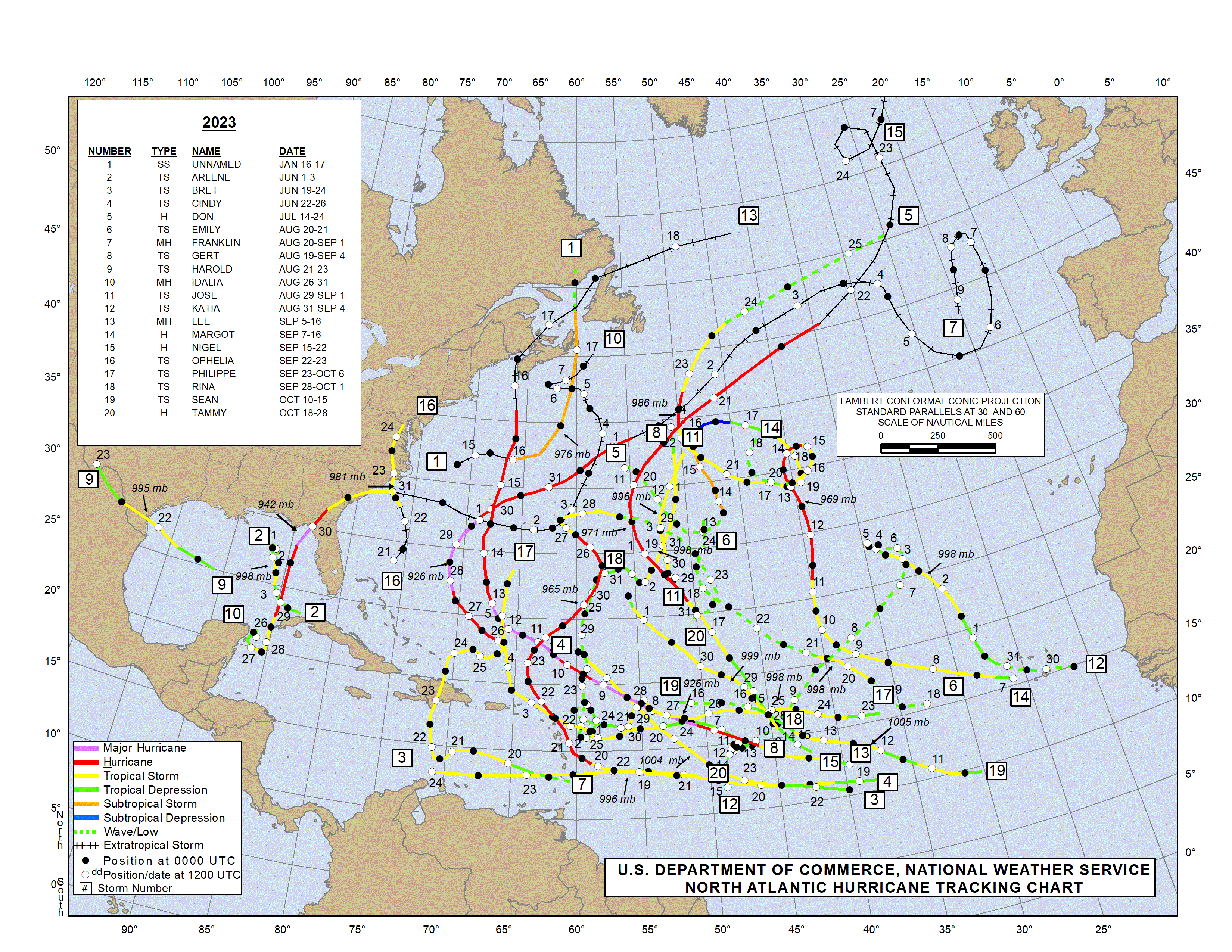
In the following article, we  look at NOAA and Colorado State University forecasts for the 2024 Atlantic Hurricane Season which is expected to be very active.

NHC Data Archive

We will continue coverage of Hurricane Preparedness Week by looking at some of the hazards starting tomorrow.  Additional Hurricane information can be found in our static Hurricane Zone tab.


Hurricane Prep Series
Read entire series (click here)

More links and information about tropical storms and other weather conditions can be found in the Weather & Hurricane Zone tabs above.


If you live in, or plan to vacation in, an area where hurricanes are prevalent, please prepare in advance by reading our series.


I recently completed extensive training and have become Travel Safety Verified. As your dedicated Travel Advisor, your safety is our priority, and it's our job to ensure you have the necessary information you need to give you confidence and peace of mind when making your future travel plans. Click the link to review our Travel Safety program with valuable resources that will answer many of your questions.


Where have you explored? 

Gather your travel and food pics and join us every Wednesday for the latest installment of #FoodTravelChat


Friday, June 21, 2024

2024 Hurrican Season Predictions

NOAA predicts above-normal 

2024 Atlantic hurricane season


The 2024 Atlantic Hurricane Season has officially begun with the first named storm.   The National Hurricane Center is prediting above-normal season due to  La Nina and warmer-than-average ocean temperatures.

Alberto, hurricane season's first named storm, dissipates over Mexico 
 Alberto, the first named tropical storm of the Atlantic hurricane season, has dissipated after being downgraded to a tropical depression, the National Hurricane Center in Miami announced Thursday evening, but not before the storm dumped heavy rain and caused major flooding in parts of Mexico and Texas.  Torrential rains causing flooding are continuing as the storm dissipates.

Several ships operate out of Galveston, Texas so there were many eyes focased on the weather to see if there would be any disruptions. 


2024 Atlantic Hurricane Season


NOAA National Weather Service forecasters at the Climate Prediction Center predict above-normal hurricane activity in the Atlantic basin this year. NOAA’s outlook for the 2024 Atlantic hurricane season, which spans from June 1 to November 30, predicts an 85% chance of an above-normal season, a 10% chance of a near-normal season and a 5% chance of a below-normal season. 

NOAA is forecasting a range of 17 to 25 total named storms (winds of 39 mph or higher). Of those, 8 to 13 are forecast to become hurricanes (winds of 74 mph or higher), including 4 to 7 major hurricanes (category 3, 4 or 5; with winds of 111 mph or higher). Forecasters have a 70% confidence in these ranges.

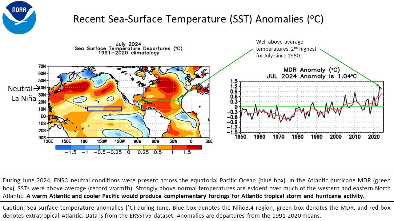
Several factors, including near-record warm ocean temperatures in the Atlantic Ocean, development of La Nina conditions in the Pacific, reduced Atlantic trade winds and less wind shear, all of which tend to favor tropical storm formation are influcing their prediction.


Storm Names 2024


Useful Information and Links - Traveling during Hurricane Season

Cruise lines have travel apps and ask for emails and cell phone numbers for all guests.  This allows them to communicate any urgent announcements to their guests.  Be sure to provide them to your travel advisor or cruise line.   They will also update their websites and FB pages with updates that impact guests due to storms or other issues.  Some of these are always active links like the following:


Hurricane Season Dates 
Hurricane Prep Series
Read entire series (click here)


Hurricane season in the Atlantic begins June 1st and ends November 30th. The Eastern Pacific hurricane season begins May 15th and also ends November 30th.
Make a Plan (FEMA) 


More links and information about tropical storms and other weather conditions can be found in the Weather & Hurricane Zone tabs above.


If you live in, or plan to vacation in, an area where hurricanes are prevalent, please prepare in advance by reading our series.


Connect With Us On

I recently completed extensive training and have become Travel Safety Verified. As your dedicated Travel Advisor, your safety is our priority, and it's our job to ensure you have the necessary information you need to give you confidence and peace of mind when making your future travel plans. Click the link to review our Travel Safety program with valuable resources that will answer many of your questions.


Where have you explored? 

Gather your travel and food pics and join us every Wednesday  for the latest installment of #FoodTravelChat


Monday, June 3, 2019

NOAA 2019 Hurricane Predictions

Credit NOAA (click to enlarge)

Predictions for 
2019 Hurricane Season


We've already provided you with Colorado State University's April Prediction for the Atlantic Basin.  NOAA has just released its predictions for the Atlantic Basin, Central and East Pacific regions.


Looking Back and Looking Ahead
Hurricane Season Approaching 

Looking Back at 2018

The 2018 Atlantic hurricane season  was the third in a consecutive series of above-average and damaging hurricane seasons, featuring 17 named storms, 10 hurricanes and 6 major hurricanes. The season will be best remembered for Hurricanes Florence and Michael, which caused significant damage in the Southeastern United States. 2018 was the first season since 2008 to feature four named storms active simultaneously (Florence, Helene, Isaac, and Joyce). The season also was the first on record to see seven storms that were subtropical at some point in their lifetimes (Alberto, Chris, Debby, Ernesto, Joyce, Leslie, and Oscar).

In the chart below, the numbers in parenthesis are the averages, so you can easily see that the 2018 Atlantic Hurricane Season was well above average.  For more details, read  NOAA: Destructive 2018 Atlantic hurricane season draws to an end.


Atlantic Basins

Forecast Parameter and 1950-2000
Climatology (in parentheses)
NOAA 2018
Prediction
2018
Actual
Named Storms (NS) (12.0)10 - 1615
Hurricanes (H) (6.5)5 - 98
Major Hurricanes (MH) (2.0)1 - 42
Accumulated Cyclone Energy (ACE) (92.0)63 - 145133


Atlantic Hurricane Outlook & Seasonal Climate Summary Archive

The 2018 Pacific hurricane season produced the highest accumulated cyclone energy (ACE) value on record. With 23 named storms, it was the fourth-most active season on record, tied with 1982.

East Pacific


Forecast Parameter and 1950-2000
Climatology (in parentheses)
NOAA 2018
Prediction
2018
Actual
Named Storms (NS) (9.6)14 - 2023
Hurricanes (H) (5.9)7- 1213
Major Hurricanes (MH) (2.3)3 - 710
Accumulated Cyclone Energy (ACE) (96.1) 80 - 160202

Looking Ahead to 2018


As is customary, the Colorado State University releases its predictions in December and April. See our blog post,  2019 CSU Atlantic Hurricane Predictionfor their 2019 predictions.


click to enlarge


Forecasters predict a 40% chance of a near-normal season, a 30% chance of an above-normal season and a 30% chance of a below-normal season for the upcoming hurricane season, which extends from June 1 to November 30.

NOAA’s forecasters predict a 70-percent likelihood of 9 to 15 named storms (winds of 39 mph or higher), of which 4 to 8 could become hurricanes (winds of 74 mph or higher), including 2 to 4 major hurricanes (category 3, 4 or 5; with winds of 111 mph or higher). An average hurricane season produces 12 named storms, of which 6 become hurricanes, including 3 major hurricanes.

East Pacific

An 80 percent chance of a near- or above-normal season is predicted for both the eastern and central Pacific regions. The eastern Pacific outlook calls for a 70-percent probability of 14 to 20 named storms, of which 7 to 12 are expected to become hurricanes, including 3 to 7 major hurricanes.

Central Pacific

The central Pacific outlook calls for a 70-percent probability of 5 to 8 tropical cyclones, which includes tropical depressions, tropical storms and hurricanes.

Measuring total seasonal activity: The Accumulated Cyclone Energy (ACE) index

ACE - Atlantic / Pacific

click images to enlarge


An important measure of the total overall seasonal activity is the NOAA Accumulated Cyclone Energy (ACE) index, which accounts for the intensity and duration of named storms and hurricanes during the season.  According to NOAA’s hurricane season classifications, an ACE value above 117% of the 1950-2000 median reflects an above-normal season. An ACE value above 175% of the median reflects an exceptionally active (or hyperactive) season.

Hurricane Season Dates 

Hurricane season in the Atlantic begins June 1st and ends November 30th. The Eastern Pacific hurricane season begins May 15th and also ends November 30th.
Make a Plan (FEMA) 


Read entire series (click here)

More links and information about tropical storms and other weather conditions can be found in the Weather & Hurricane Zone tabs above.


If you live in, or plan to vacation in, an area where hurricanes are prevalent, please prepare in advance by reading our series.