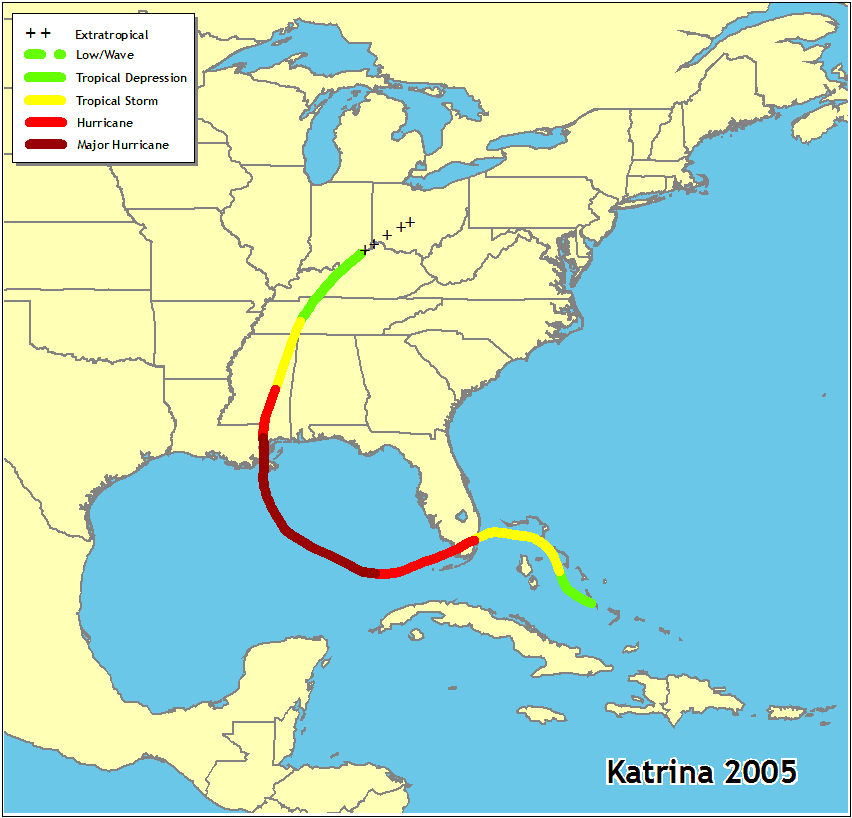
Katrina was an extraordinarily powerful and deadly hurricane that first caused fatalities and damage in southern Florida as a Category 1 hurricane on the Saffir-Simpson Hurricane Scale. After reaching Category 5 intensity over the central Gulf of Mexico, Katrina weakened to Category 3 before making landfall on the northern Gulf coast.
Even so, the damage and loss of life inflicted by this massive hurricane in Louisiana and Mississippi were staggering, with significant effects extending into the Florida panhandle, Georgia, and Alabama. Considering the scope of its impacts, Katrina was one of the most devastating natural disasters in United States history.
New Orleans was severely impacted by Katrina, and has since rebuilt the levees that failed them back in 2005. The burning question for town residents tonight was - would they hold with this latest approaching storm.
Fortunately, Hurricane Isaac was a much weaker storm, but don't let that fool you. It had the potential to bring heavy rains, flooding, power outages, damaging winds, and all the hazards associated with tropical cyclones.
Isaac, which spans more than 200 miles, made landfall at about 6:45 p.m. local time near the mouth of the Mississippi River. New Orleans, about 75 miles to the northwest, was a ghost town as residents and tourists heeded warnings to stay indoors. Except for low-lying areas which were under mandatory evacuation orders, the majority of the folks stayed here to ride out the storm.
Following is a comparison of the two storms. We trace some of the significant milestones as the two storms headed from the Atlantic to the Caribbean Sea and into the Gulf of Mexico before making landfall. For those that want even more information, see the storm and graphic archives on the NHC website.
For Latest Impact (click here): Tropical Storm Isaac in Atlantic

| DATE / TIME | KATRINA 2005 | ISAAC 2012 |
 |
 |
|
| Storm Milestones, Watches & Warnings Issued | ||
| 21 AUG | 500 AM AST TUE AUG 21 2012 TD-9 forms east of Lesser Antilles, TS Warnings / Watches issued 1007 MB / 35 MPH 500 PM AST TUE AUG 21 2012 Strengthens to tropical storm 1006 MB / 40 MPH 1100 PM AST TUE AUG 21 2012 Puerto Rico, Virgin Islands |
|
| 22 AUG | 500 AM AST WED AUG 22 2012 Dominican Republic 1003 MB / 45 MPH 800 AM AST WED AUG 22 2012 British Virgin Islands 1004 MB / 45 MPH 200 PM AST WED AUG 22 2012 Leeward Islands 1006 MB / 45 MPH 500 PM AST WED AUG 22 2012 Haiti 1004 MB / 45 MPH 1100 PM AST WED AUG 22 2012 Eastern Caribbean 1003 MB / 45 MPH | |
| 23 AUG | 500 PM EDT TUE AUG 23 2005 TD 12 forms - Bahamas TS Warnings issued 1007 MB / 35 MPH 1100 PM EDT TUE AUG 23 2005 Florida Keys, East coast 1007 MB / 35 MPH |
1100 AM AST THU AUG 23 2012 South of Virgin Islands 1003 MB / 40 MPH 500 PM AST THU AUG 23 2012 Bahamas, Cuba 1003 MB / 40 MPH 1100 PM AST THU AUG 23 2012 Hispaniola 1001 MB / 45 MPH |
| 24 AUG | 1100 AM EDT WED AUG 24 2005 Becomes tropical storm Bahamas, Florida 1006 MB / 40 MPH 500 PM EDT WED AUG 24 2005 SE Florida 1002 MB / 45 MPH 1100 PM EDT WED AUG 24 2005 Hurricane warnings 1001 MB / 50 MPH |
800 AM EDT FRI AUG 24 2012 Jamaica 1000 MB / 50 MPH 200 PM EDT FRI AUG 24 2012 Southern Hisapniola 997 MB / 50 MPH 1100 PM EDT FRI AUG 24 2012 Haiti Landfall 990 MB / 70 MPH |
| 25 AUG | 800 AM EDT THU AUG 25 2005 Better organized 999 MB / 50 MPH 1100 AM EDT THU AUG 25 2005 Florida straits 997 MB / 60 MPH 300 PM EDT THU AUG 25 2005 Near hurricane strength 990 MB / 70 MPH 500 PM EDT THU AUG 25 2005 Cat 1 Hurricane 985 MB / 75 MPH 900 PM EDT THU AUG 25 2005 Eye over NHC 984 MB / 80 MPH 1100 PM EDT THU AUG 25 2005 Eye over Miami-Dade 984 MB / 75 MPH |
500 AM EDT SAT AUG 25 2012 South Florida, Keys 992 MB / 60 MPH 1100 AM EDT SAT AUG 25 2012 Florida East Coast 998 MB / 60 MPH 200 PM EDT SAT AUG 25 2012 East Coast Cuba 1000 MB / 60 MPH 1100 PM EDT SAT AUG 25 2012 Straits of Florida 997 MB / 60 MPH |
| 26 AUG | 100 AM EDT FRI AUG 26 2005 Weakens over land 980 MB / 70 MPH 700 AM EDT FRI AUG 26 2005 Westward over Gulf 987 MB / 75 MPH 1100 AM EDT FRI AUG 26 2005 Stronger - West of Florida 981 MB / 80 MPH 200 PM EDT FRI AUG 26 2005 Cat 2 Hurricane 969 MB / 100 MPH 1100 PM EDT FRI AUG 26 2005 Expected to intensify 965 MB / 105 MPH |
800 AM EDT SUN AUG 26 2012 Florida Keys 995 MB / 65 MPH 500 PM EDT SUN AUG 26 2012 Key West 992 MB / 60 MPH 1100 PM EDT SUN AUG 26 2012 Eastern Gulf of Mexico 993 MB / 65 MPH |
| 27 AUG | 200 AM EDT SAT AUG 27 2005 963 MB / 110 MPH 800 AM EDT SAT AUG 27 2005 Cat 3 Hurricane 940 MB / 115 MPH 400 PM CDT SAT AUG 27 2005 Louisiana 945 MB / 115 MPH 1000 PM CDT SAT AUG 27 2005 Threat North Central Gulf 939 MB / 115 MPH |
500 AM EDT MON AUG 27 2012 Louisiana Coast 990 MB / 65 MPH 1000 AM CDT MON AUG 27 2012 Eastern Gulf of Mexico 988 MB / 65 MPH 400 PM CDT MON AUG 27 2012 Storm surge threat 981 MB / 70 MPH 1000 PM CDT MON AUG 27 2012 Flooding threat 979 MB / 70 MPH |
| 28 AUG | 100 AM CDT SUN AUG 28 2005 Cat 4 Hurricane New Orleans 935 MB / 145 MPH 700 AM CDT SUN AUG 28 2005 Cat 5 Hurricane Northern Gulf Coast 908 MB / 165 MPH 100 PM CDT SUN AUG 28 2005 Still Cat 5 906 MB / 175 MPH 1000 PM CDT SUN AUG 28 2005 Cat 5 904 MB / 160 MPH |
400 AM CDT TUE AUG 28 2012 Verge of becoming hurricane 977 MB / 70 MPH 1120 AM CDT TUE AUG 28 2012 Becomes Cat 1 Hurricane 975 MB / 75 MPH 700 PM CDT TUE AUG 28 2012 Landfall Extreme SE Louisiana 970 MB / 80 MPH 1000 PM CDT TUE AUG 28 2012 Dangerous storm surge; flooding 968 MB / 80 MPH |
| 29 AUG | MIDNIGHT CDT MON AUG 29 2005 Nearing Louisiana coast 908 MB / 160 MPH 600 AM CDT MON AUG 29 2005 Cat 4 Near Shore 918 MB / 145 MPH 800 AM CDT MON AUG 29 2005 Pounding SE Louisiana 923 MB / 135 MPH 1000 AM CDT MON AUG 29 2005 Weakens to Cat 3 Moving ashore near Louisiana & Mississippi border 927 MB / 125 MPH NOON CDT MON AUG 29 2005 Weakens to Cat 2 over land 940 MB / 105 MPH 400 PM CDT MON AUG 29 2005 Weakens to Cat 1 960 MB / 75 MPH 700 PM CDT MON AUG 29 2005 Now a tropical storm 965 MB / 65 MPH 1000 PM CDT MON AUG 29 2005 Coastal warnings discontinued 973 MB / 60 MPH |
1200 AM CDT WED AUG 29 2012 Coast of Louisiana 969 MB / 80 MPH 200 AM CDT WED AUG 29 2012 Nearly stationary 968 MB / 80 MPH 300 AM CDT WED AUG 29 2012 Second landfall 969 MB / 80 MPH 400 AM CDT WED AUG 29 2012 Begins Moving Inland 969 MB / 80 MPH 600 AM CDT WED AUG 29 2012 Floods and heavy rains continue 970 MB / 80 MPH 800 AM CDT WED AUG 29 2012 970 MB / 80 MPH 1200 PM CDT WED AUG 29 2012 SE Louisiana / Mississippi Rains 973 MB / 75 MPH 200 PM CDT WED AUG 29 2012 Weakens to Tropical Storm 974 MB / 70 MPH 700 PM CDT WED AUG 29 2012 Slow moving - only 6 MPH 977 MB / 60 MPH 1000 PM CDT WED AUG 29 2012 Only moved 60 miles all day 980 MB / 60 MPH |
| 30 AUG | 400 AM CDT TUE AUG 30 2005 Weakens further 981MB / 50 MPH 1000 AM CDT TUE AUG 30 2005 Still heavy rainfall Weakens to tropical depression 985 MB / 35 MPH |
100 AM CDT THU AUG 30 2012 Heavy Rains & Severe Weather Farther inland Louisiana 981 MB / 50 MPH 400 AM CDT THU AUG 30 2012 983 MB / 45 MPH 1000 AM CDT THU AUG 30 2012 987 MB / 40 MPH 400 PM CDT THU AUG 30 2012 Weakens to Tropical Depression 995 MB / 35 MPH |
| 31 AUG | No Advisories Issued |
No Advisories Issued |
No comments:
Post a Comment