Showing posts with label closed. Show all posts

Friday, August 25, 2017

Hurricane Harvey Closes Port of Galveston

 
Courtesy NHC - Click for More Graphics

HURRICANE HARVEY


Hurricane Harvey
800 AM CDT Fri Aug 25 2017

...8 AM CDT POSITION ESTIMATE...
...TROPICAL STORM FORCE WINDS NEARING THE COAST OF TEXAS...
WIND:
MAXIMUM SUSTAINED WINDS...110 MPH...175 KM/H
WATCHES/ WARNINGS:
SUMMARY OF WATCHES AND WARNINGS IN EFFECT:

A Storm Surge Warning is in effect for...
* Port Mansfield to High Islan
d Texas

A Storm Surge Watch is in effect for...
* South of Port Mansfield Texas to the Mouth of the Rio Grande

A Hurricane Warning is in effect for...
* Port Mansfield to Sargent Texas

A Tropical Storm Warning is in effect for...
* North of Sargent to High Island Texas
* South of Port Mansfield Texas to the Mouth of the Rio Grande

A Hurricane Watch is in effect for...
* South of Port Mansfield Texas to the Mouth of the Rio Grande

A Tropical Storm Watch is in effect for...
* South of the Mouth of the Rio Grande to Boca de Catan Mexico
SHIP IMPACT:
Carnival Cruise Line 
Disney Cruise Line
Royal Caribbean
Norwegian Cruise Line

Carnival & Royal are actively tracking Harvey 
     
Storm Archive       Graphics Archive

A Storm Surge Warning means there is a danger of life-threatening
inundation from rising water moving inland from the coastline in the
indicated locations. For a depiction of areas at risk, please see
the National Weather Service Storm Surge Watch/Warning Graphic,
available at hurricanes.gov.  This is a life-threatening situation.
Persons located within these areas should take all necessary actions
to protect life and property from rising water and the potential for
other dangerous conditions.  Promptly follow evacuation and other
instructions from local officials.

A Hurricane Warning means that hurricane conditions are expected
somewhere within the warning area, in this case within the next 12
to 24 hours. Preparations to protect life and property should be
rushed to completion.

A Storm Surge Watch means there is a possibility of life-
threatening inundation, from rising water moving inland from the
coastline, in the indicated locations during the next 48 hours.

A Hurricane Watch means that hurricane conditions are possible
within the watch area.

In addition, interests in southwestern Louisiana should continue to
monitor the progress of this system.


ITINERARY UPDATES August 27, 2017 Royal Caribbean International is diverting Liberty of the Seas to Miami until conditions at the Port of Galveston permit safe travel. Due to port closure because of Hurricane Harvey, Liberty was not able to make her scheduled arrival into Galveston today. We anticipate Liberty will be able to return to Galveston on Friday, conditions permitting. We are doing all we can to help guests adjust their travel arrangements and appreciate their patience as we work through this. The next sailing of Liberty of the Seas, scheduled for Sunday, August 27 has been cancelled, and all guests will have their fares fully refunded and have been provided a future cruise credit. If you have any questions, please do not hesitate to contact us at 1(866) 562-7625.
Carnival Cruise Line Advisory (click for latest alerts)


WEATHER UPDATE #3 – 08/25/17 – 1:00 PM (EST)

Carnival Valor and Carnival Freedom are currently keeping a safe distance from the storm as they make their way back to Galveston.

Carnival Breeze is currently docked in Cozumel and will now overnight there. The ship will depart for Galveston tomorrow afternoon to be in position to debark guests when the port reopens. The Port of Galveston is closed to all marine traffic. It is expected to remain closed until the storm has passed and a port assessment has been completed.

Please do not proceed to the cruise terminal until you have heard from us. Our intention is to dock in Galveston as soon as port officials have reopened the port. The duration of your cruise will have to be shortened and the itinerary modified. Cruise details will be finalized once we have confirmed our arrival into Galveston.

Guests who sail will receive a pro-rated refund of their cruise fare for missed days and refund of any pre-purchased Carnival Adventures for canceled ports. Additionally, guests who pre-purchased any of our beverage packages will receive a pro-rated refund. Gratuities will also be adjusted to reflect the shortened duration.

We certainly understand the impact Hurricane Harvey is having on your cruise plans. Should you wish to cancel and receive a future cruise credit, please call 1-800-CARNIVAL, contact your Personal Vacation Planner at 1-800-819-3902, or your travel agent.

4 Things To Help Plan Vacation in Hurricane Season

We continue to actively monitor the storm and will update you tomorrow at 3:00PM CDT.

To stay up to date on any changes, guests are asked to sign up for text alerts by texting the codes below to CRUISE (278473).

Carnival Freedom 08/26/17 - CCL1
Carnival Valor 08/26/17 - CCL2
Carnival Breeze 08/27/17 - CCL3


Hurricane Preparedness Mini-Series:

Friday, July 12, 2013

Ethiopian 787 Dreamliner Fire Closes Heathrow

Ethiopian Dreamliner Fire at LHR      Courtesy Sky News
London Heathrow Suspended Flights Temporarily

According to London Heathrow airport website, a fire broke out on a parked Ethiopian Boeing 787 Dreamliner causing a suspension in flights in and out of the airport.  As of this writing, there is a resumption of flights, but they are advising you check with your airlines for possible delays.

The good news is that noone appears to have been injured as there were no passengers onboard at the time of the incident.   Several fire brigades responded to the scene and runways were closed while the fire was contained.

UPDATED: 12 July 2013 - 1:45 PM Eastern

The runways are now fully re-opened, following an earlier internal fire on-board an aircraft. All arrivals and departures were earlier temporarily suspended while airport fire crews attended to the incident. Flights are now operating, but will be subject to delay.

Please check the status of your flight with your airline before travelling to Heathrow.

The Metropolitan Police Service have advised that there were no passengers on board and no reported injuries.

You can keep up-to-date by following Heathrow on Twitter and Facebook or receive individual flight status updates on the move by using our mobile app or our SMS text service.


Boeing Dreamliner Plagued with Problems

This just adds to the string of problems that have been reported with the new aircraft developed by Boeing.  Earlier this year, the FAA grounded all Dreamliners operated by U.S. companies until they could be deemed safe following problems with the batteries onboard.  Boeing found what it believed was a solution to the problem and flights resumed.


Saturday, January 21, 2012

Carnival Triumph Cruise Delayed Due to Fog

Port of Galveston 
Fogged In

Carnival Triumph 
Departure Delayed

The port of Galveston is a great place to start your cruise vacation.  The boardwalk has shops and restaurants for you to enjoy before departure.

Galveston Channel Closed
Due to dense fog (zero visibility) Galveston channel was closed today.  Therefore, Carnival Triumph’s arrival today Saturday, January 21st was delayed until conditions improved sufficiently for the channel to reopen for marine traffic. Carnival Triumph remained at anchorage at the pilot station.
Passengers Updated by Cruise Director
It looks like the fog is starting to clear nearer to the terminal and the island. It’s still pretty thick where we are. In his last announcement, Captain Los said that we might be able to board the pilot by 11:15am. This would put us alongside at 12:45pm or 1:00pm. At this point, the phone lines have been opened and are complimentary so that guests can update/change travel arrangements. We’re going to start serving lunch in about an hour. Hopefully, the fog will clear soon.
Arriving Passengers:  TEXT CCL1 to 36500 for text updates
UPDATE:  Carnival Travel Advisories
The port of Galveston is now open. Check-in is scheduled from 3:00PM–6:30PM and Triumph will set sail around 7:30PM 
No impact to the itinerary 
  ###
It is out of respect for the passengers, family, and crew of those aboard Costa Concordia, that we have been restricting our posts to that accident and related safety information.  We will continue our coverage of that tragedy, but will once again start to return to coverage of other topics of interest to our readers.   We thank you for your understanding.  Please continue to pray for all those impacted by this tragedy.   

Saturday, March 12, 2011

Azamara Quest Skips Osaka Call

Azamara Quest
Japan Closes
Ports of Call 
Impacts Azamara Quest

The devastating earthquake and the resulting tsunami that struck off the coast of Honshu, Japan yesterday, caused widespread death, injury, and damage leaving the country in a state of emergency. 
Azamara Quest was in Nagasaki, Japan at the time of the earthquake and resulting tsunami. It was on the Northeast side of Japan, in a protected bay far away from danger. The ship sailed into deep waters about an hour after the earthquake and was in no danger. The next scheduled port of call was Osaka, which is 38 hours sailing time from Nagasaki.

Azamara Club Cruises released the following statement today, as it cancelled the Quest's next port of call:

"The entire country of Japan is still assessing the extent of the damage caused by the earthquake and tsunami. While initial reports suggest that Kyoto (Osaka) did not sustain major damage, we feel that the recent events and continuing aftershocks have the potential to seriously disrupt Azamara Quest's experience and our operations in port."

Cruise lines that have upcoming calls in Japan will be monitoring the situation and making itinerary changes as necessary.   We will provide updates as we learn of any changes.

Several cruise lines issued statements in the wake of the disaster  (read more here)


Thursday, September 16, 2010

Three Hurricanes in Atlantic Basin

Port of Bermuda Closed:  September 17-21 

 Cruise Line Advisories (Click Here)


Not the storm you are looking for?  Click Image or Here

Atlantic Graphical Tropical Weather Outlook

We are monitoring three active tropical storms at the moment:

Hurricane Igor, Hurricane Julia & Hurricane Karl

Click the following links for latest updates on the respective hurricanes 

Tropical Storm Julia Forms in Atlantic

Igor Expected to Become a Hurricane 

Tropical Storm Karl Heading Toward Yucatan

In Early August, we reported that NOAA had continued their prediction of an Active / Above Normal Hurricane Season for the Atlantic Basin.    With three active hurricanes in the region at the present time, it appears their prediction is definitely accurate.

NOAA Still Predicting Active Atlantic Hurricane Season (click for story)

Impact On Cruise Ships

Real-Time Cruise Ship Tracking (click)

All cruise lines are monitoring these storms and adjusting schedules as needed.  Despite the strength of Igor and Julia, there have been minimal changes to date however, with sites set on Bermuda for this weekend, this is most likely about to change.

  Cruise Line Advisories

Port of Bermuda Closed:  September 17-21 

 Cruise Line Advisories (Click Here)

Bermuda Marine Forecast


Saturday, September 11, 2010

Igor Expected to Become a Hurricane

5-Day Forecast Cone for Hurricane IGOR (Credit: NOAA NHC)
Click for Current 5-Day Graphic

Igor is 9th Named Storm in Atlantic
Now a Category ONE Hurricane
Port of Bermuda Closed:  September 17-21  

Not the storm you are looking for?  Click Image or Here
UPDATE: 500 PM AST TUE SEP 21 2010
...IGOR BECOMES POST-TROPICAL...
 
Last NHC adivisories were issued on  Hurricane IGOR and  Tropical Storm JULIA 
Last NHC advisory issued on KARL

Updates from the Islands -
- - Bermuda - -

Locals from the Islands of Bermuda are providing updates (link above) on the approaching storm complete with pictures. We hope everyone on Bermuda Stays Safe.   

IGOR WAS A WEAKER HURRICANE THAN ANTICIPATED
 AS IT APPROACHED BERMUDA

Storm Aftermath in Bermuda... At first light, the people of Bermuda breathe a sigh of relief as they realize IGOR wasn't the predicted strength as it came ashore.  It came ashore as a Category One and not the originally predicted Category Two or Three.  Winds of 75 MPH with gusts of 90 MPH or so are much better than those in excess of 100 MPH with higher gusts.

As expected, IGOR did stay a long time due to it's massive size.   There were the anticipated power outages, wind damage, and flooding.   BELCO, the local electric company, is making plans to restore power to over 28,000 customers Monday morning.    According to local police reports, there were no fatalities or major injuries reported.

Continuing updates and news articles from Bermuda ...   click here


NEW ... NHC Live Video Updates


BDA Airport Closed
September 18th 6 PM - 21st 3 PM

See below for Cruise Line Updates

At this time,  only Hurricane Igor remains as a big threat to the region.    Hurricane Julia is now a tropical storm and Hurricane Karl has become a tropical depression after slamming into Mexico. Conditions in Bermuda will continue to deteriorate this weekend.  The eye of the storm will be closest to Bermuda late Sunday or early Monday.


As a service to our readers, we have RSS feeds from the NHC which can provide up to date information about these tropical storms.   We will also monitor the cruise lines for any itinerary changes as a result of the storms.   A special thank you to the NHC, NOAA, the cruise lines, and others who have contributed to this blog by providing updates on this very serious tropical cyclone.

LAST PUBLIC ADVISORY ISSUED BY THE NATIONAL HURRICANE
CENTER ON IGOR.  ADDITIONAL INFORMATION ON THIS SYSTEM CAN BE FOUND
IN HIGH SEAS FORECASTS ISSUED BY THE NATIONAL WEATHER SERVICE...
UNDER AWIPS HEADER NFDHSFAT1 AND WMO HEADER FZNT01 KWBC.
 
Earlier ...

Tropical Storm Igor was strengthening  Saturday September 11th and threatening to become a Hurricane.   On Sunday morning, September 12th, the storm did strengthen into a Category Two Hurricane.  The storm is going through a period of rapid intensification and as predicted has become a Major Hurricane (Category Four) within 12 hours.

There are no watches or warnings, but we will continue to monitor this storm for potential dangers.  The current storm track appears to take it over open waters for the next few days.  Igor appears to have its sights on Bermuda as it churns along with Julia in the open waters of the Atlantic.   This is the first time since the late 90s that two major hurricanes were in the Atlantic at the same time.

Current Watches & Warnings


A HURRICANE WATCH IS IN EFFECT FOR...
* THE COAST OF NEWFOUNDLAND FROM STONES COVE NORTHWARD AND EASTWARD
TO FOGO ISLAND
 
A TROPICAL STORM WARNING IS IN EFFECT FOR...
* THE COAST OF NEWFOUNDLAND FROM BURGEO NORTHWARD AND EASTWARD
TO TRITON
* THE ISLANDS OF ST-PIERRE AND MIQUELON
 
THESE WATCHES AND WARNINGS WILL LIKELY BE DISCONTINUED THIS EVENING
OR TONIGHT. (21 Sep)
 
A TROPICAL STORM WARNING MEANS THAT TROPICAL STORM CONDITIONS ARE
EXPECTED SOMEWHERE WITHIN THE WARNING AREA WITHIN 36 HOURS.

A TROPICAL STORM WATCH MEANS THAT TROPICAL STORM CONDITIONS ARE
POSSIBLE WITHIN THE WATCH AREA...GENERALLY WITHIN 48 HOURS.

A HURRICANE WARNING MEANS THAT HURRICANE CONDITIONS ARE EXPECTED
SOMEWHERE WITHIN THE WARNING AREA. A WARNING IS TYPICALLY ISSUED
36 HOURS BEFORE THE ANTICIPATED FIRST OCCURRENCE OF TROPICAL-STORM-
FORCE WINDS...CONDITIONS THAT MAKE OUTSIDE PREPARATIONS DIFFICULT
OR DANGEROUS. PREPARATIONS TO PROTECT LIFE AND PROPERTY SHOULD BE
RUSHED TO COMPLETION. 
 
A HURRICANE WATCH MEANS THAT HURRICANE CONDITIONS ARE POSSIBLE
WITHIN THE WATCH AREA.  A WATCH IS TYPICALLY ISSUED 48 HOURS
BEFORE THE ANTICIPATED FIRST OCCURRENCE OF TROPICAL-STORM-FORCE
WINDS...CONDITIONS THAT MAKE OUTSIDE PREPARATIONS DIFFICULT OR
DANGEROUS.
 
FOR STORM INFORMATION SPECIFIC TO YOUR AREA IN THE UNITED
STATES...INCLUDING POSSIBLE INLAND WATCHES AND WARNINGS...PLEASE
MONITOR PRODUCTS ISSUED BY YOUR LOCAL NATIONAL WEATHER SERVICE
FORECAST OFFICE. FOR STORM INFORMATION SPECIFIC TO YOUR AREA OUTSIDE
THE UNITED STATES...PLEASE MONITOR PRODUCTS ISSUED BY YOUR NATIONAL
METEOROLOGICAL SERVICE.
 
Discussion & Outlook
  
SUMMARY OF 500 PM AST...2100 UTC...INFORMATION (21 Sep)
 
LOCATION...49.3N 51.7W
ABOUT 125 MI...200 KM NNE OF ST. JOHNS NEWFOUNDLAND
MAXIMUM SUSTAINED WINDS...80 MPH...130 KM/HR
PRESENT MOVEMENT...NNE OR 25 DEGREES AT 39 MPH...63 KM/HR
MINIMUM CENTRAL PRESSURE...950 MB...28.05 INCHES

MAXIMUM SUSTAINED WINDS ARE NEAR 80 MPH...130 KM/HR...WITH HIGHER
GUSTS.  LITTLE CHANGE IN STRENGTH IS EXPECTED DURING THE NEXT 24
HOURS...BUT THE CYCLONE SHOULD BEGIN TO GRADUALLY WEAKEN BY LATE
WEDNESDAY.
 
HURRICANE FORCE WINDS EXTEND OUTWARD UP TO 85 MILES...140 KM...FROM
THE CENTER...AND TROPICAL STORM FORCE WINDS EXTEND OUTWARD UP TO 520
MILES...835 KM.
 
ESTIMATED MINIMUM CENTRAL PRESSURE IS 950 MB...28.05 INCHES.


HAZARDS AFFECTING LAND


WIND...WINDS OF TROPICAL STORM FORCE AND VERY NEAR HURRICANE
FORCE...ESPECIALLY IN GUSTS...ARE OCCURRING IN PARTS OF
NEWFOUNDLAND.  THESE WINDS WILL LIKELY DIMINISH TONIGHT AS IGOR
MOVES FARTHER TO THE NORTH.
 
RAINFALL...THE SIGNIFICANT RAINFALL THREAT OVER NEWFOUNDLAND
ASSOCIATED WITH IGOR HAS COME TO AN END.  RAINFALL WILL BE TAPERING
OFF THIS EVENING AS IGOR MOVES RAPIDLY NORTH-NORTHEASTWARD.
 
SURF...LARGE SWELLS ALONG THE EAST COAST OF THE UNITED STATES WILL
BE SUBSIDING TONIGHT.  SWELLS WILL BE SLOW TO SUBSIDE IN NOVA
SCOTIA...NEWFOUNDLAND...PUERTO RICO...THE VIRGIN ISLANDS...
HISPANIOLA...AND PORTIONS OF THE BAHAMAS DURING THE NEXT COUPLE OF
DAYS.  THESE SWELLS ARE LIKELY TO CAUSE LIFE-THREATENING SURF AND
RIP CURRENTS. PLEASE CONSULT PRODUCTS FROM YOUR LOCAL WEATHER
OFFICE FOR ADDITIONAL INFORMATION.


 Cruise Line Advisories

No New Advisories Issued since IGOR left Bermuda


Changes in cruise itineraries have been made due to storm surge and surf predicted with Hurricane Igor.   Bermuda Marine Forecast        NEW ...  NHC unveils new Storm Surge web page
 

Carnival Cruise Line :

No current advisories due to Hurricane Igor

September 14, 2010

Carnival Dream will swap its St. Maarten and St. Thomas calls. The ship will now visit St. Maarten on Tuesday from 11 a.m. to 7 p.m. and St. Thomas on Wednesday from 7 a.m. to 6 p.m.


IMPORTANT TRAVEL ALERT!! Please note that due to severe weather conditions in the Atlantic Ocean, the MSC Poesia will not be calling in Hamilton, Bermuda on September 18th as originally scheduled. Instead, she will sail to Boston as detailed below:


Arrival: Saturday, September 18th 9:00am
Departure: Monday, September 20th 7:00am


After sailing along the US Coast, the ship will arrive in New York City on Tuesday, September 21 as scheduled. Please keep in mind that this change in itinerary is to ensure the safety of all guests and crew aboard the MSC Poesia.


Norwegian Cruise Line:


Updated September 17, 2010 at 9:30 AM EST

At Norwegian Cruise Line, the safety and security of our guests and crew is of the utmost importance. Therefore, the company is closely monitoring the paths of Hurricane Igor, Hurricane Julia and Hurricane Karl.

As Hurricane Igor is forecasted to pass over the island of Bermuda this weekend, Norwegian Spirit’s itinerary has changed. The ship will now sail to Orlando (Port Canaveral), Florida and Nassau, Bahamas. The ship will depart Boston today as scheduled at 4 p.m. and spend two days at sea before it arrives in Orlando on Monday, September 20 and then to Nassau on Tuesday, September 21.

All other Norwegian ships will depart their respective homeports according to the published schedule.

Any further updates will be posted to ncl.com.


Royal Caribbean International:

September 17, 2010  11:00 a.m. E.S.T


Due to the forecasted path of Hurricane Igor, Royal Caribbean International is altering the itineraries of Enchantment of the Seas, Majesty of the Seas and Monarch of the Seas.

Enchantment of the Seas will be unable to make its scheduled port call to Bermuda. The Port of Bermuda will be closed beginning Friday, September 17 and is not scheduled to reopen until Tuesday, September 21 due to the forecasted path of Hurricane Igor. As a result, Enchantment of the Seas will now sail to Nassau, Bahamas, were it will arrive on Monday, September 20, and stay overnight until noon on Tuesday, September 21.

Majesty of the Seas will be unable to make its scheduled port call to CocoCay on Saturday, September 18, as scheduled. The ship will now sail directly to Nassau and stay overnight until 5:00 p.m. on Sunday, September 19. Majesty of the Seas is sailing a three-night Bahamas itinerary, which will depart the Port of Miami on September 17.

Monarch of the Seas will be unable to make its scheduled port call to CocoCay on Sunday, September 19, as scheduled. The ship will now stay overnight in Nassau until 5:00 p.m. on Sunday, September 19. Monarch of the Seas is sailing a three-night Bahamas itinerary, which will depart Port Canaveral on September 17.

No other Royal Caribbean International ship's itinerary is currently being affected by Hurricane Igor. Royal Caribbean will continue to closely monitor weather conditions and will update this information if there are any additional itinerary alterations due to the storm's projected path.

Although the itinerary modifications are clearly caused by weather and a situation beyond the line's control, the line said it will provide— "as a gesture of goodwill and to thank guests for their understanding"— each stateroom with an onboard credit.

If guests opt to not sail on the revised itinerary, they also may cancel and receive a letter of credit for the amount of the cruise paid to Royal Caribbean. That letter of credit may be applied to a future Royal Caribbean cruise.

No other Royal Caribbean International ship's itinerary is currently being affected by Hurricane Igor. Royal Caribbean will continue to closely monitor weather conditions and will update this information if there are any additional itinerary alterations due to the storm's projected path.


Celebrity Cruises:


Tropical Weather Update - (September 15, 2010 - 4:00 p.m  E.S.T) - At this time, Celebrity Cruises is closely monitoring the path and progress of Hurricane Igor to ensure guests enjoy safe and comfortable cruises, and to make certain our ships steer clear of the storm. The safety of our guests and crew is always the foremost concern of Celebrity Cruises.

Given Hurricane Igor's current location and projected path, Celebrity Cruises has not altered the itineraries of any ships. Celebrity Cruises will continue to closely monitor weather conditions and will update this information if there are any changes to the storms' projected path.

Saturday, February 27, 2010

Powerful Quake Hits Chile Tsunami Alert

Source: USGS, NEIC
Magnitude 8.8 Earthquake
Offshore Maule, Chile

Saturday, February 27, 2010
03:34:14 AM at epicenter


A powerful Magnitude 8.8 Earthquake hit offshore Maule, Chile early Saturday morning damaging buildings, bridges, and vehicles while causing severe injury and death in its path. President-elect Sebastian Pinera said more than 120 people died, but that number was rising quickly.


A series of after shocks continues to strike the continent of South America. The quake shook buildings in Argentina's capital of Buenos Aires, and was felt as far away as Sao Paulo in Brazil — 1,800 miles (2,900 kilometers) to the east.

Charities and governments of the world have mobilized to provide humanitarian aide to Chile. Our thoughts and prayers go out to the people impacted by this tragedy.

(see below for impact on cruise ships)


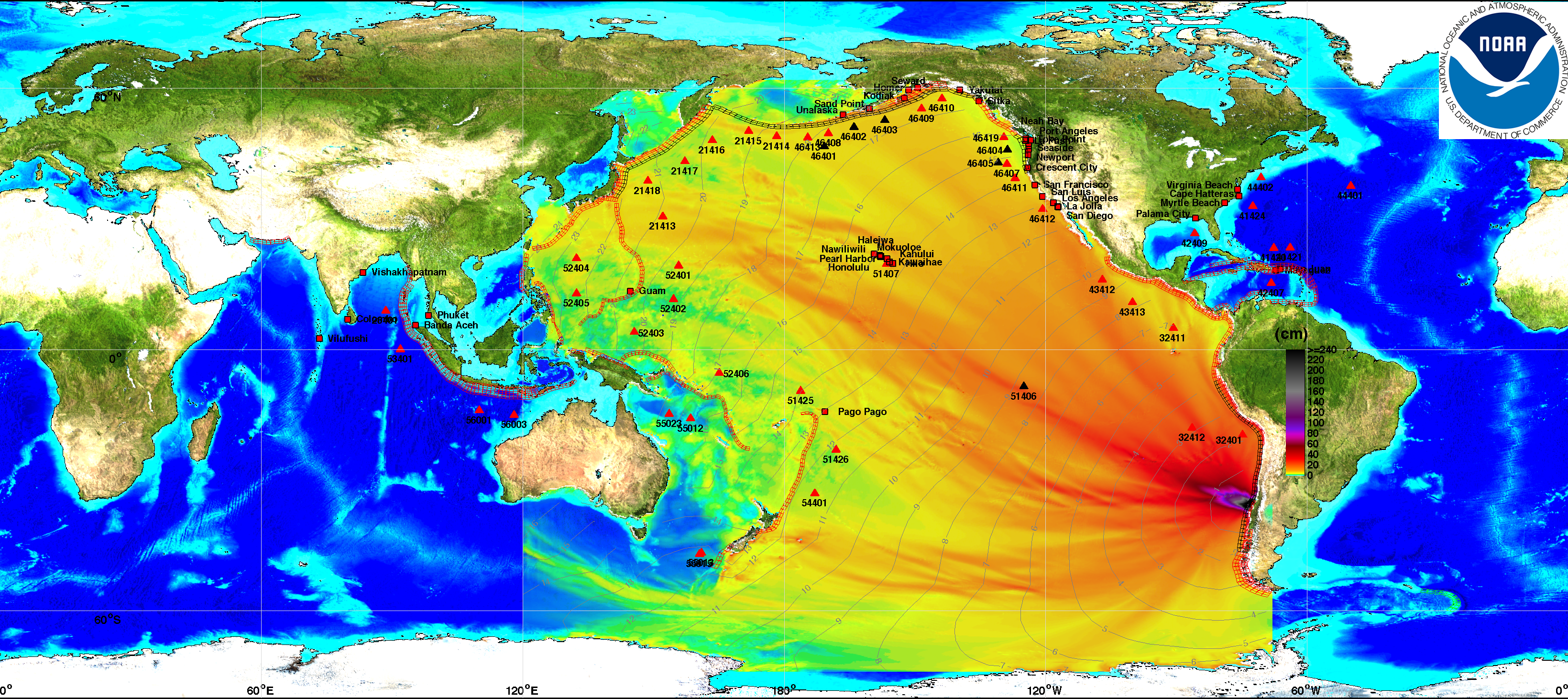
THIS BULLETIN APPLIES TO AREAS WITHIN AND BORDERING THE PACIFIC OCEAN AND ADJACENT SEAS...


This energy map provided courtesy of
West Coast & Alaska Tsunami Warning Center

NOAA Interactive map (click here)

UPDATE: Sunday, February 28th
TSUNAMI WARNINGS LIFTED


As the tsunami waves, generated by the Chile earthquake, reached the shores of Japan and Russia there was a sigh of relief across the globe. The waves were smaller than expected causing minimal flooding in most cases.


A WIDESPREAD TSUNAMI WARNING
IS IN EFFECT FOR ...

CHILE / PERU / ECUADOR / COLOMBIA / ANTARCTICA / PANAMA /
COSTA RICA / NICARAGUA / PITCAIRN / HONDURAS / EL SALVADOR /
GUATEMALA / FR. POLYNESIA / MEXICO / COOK ISLANDS / KIRIBATI /
KERMADEC IS / NIUE / NEW ZEALAND / TONGA / AMERICAN SAMOA /
SAMOA / JARVIS IS. / WALLIS-FUTUNA / TOKELAU / FIJI /
AUSTRALIA / HAWAII / PALMYRA IS. / TUVALU / VANUATU /
HOWLAND-BAKER / NEW CALEDONIA / JOHNSTON IS. /
SOLOMON IS. /NAURU / MARSHALL IS. / MIDWAY IS. / KOSRAE /
PAPUA NEW GUINEA /POHNPEI / WAKE IS. / CHUUK / RUSSIA /
MARCUS IS. / INDONESIA /N. MARIANAS / GUAM / YAP / BELAU /
JAPAN / PHILIPPINES /CHINESE TAIPEI

RSS feeds have been added (right column) bringing you latest updates from the
Pacific Tsunami Warning Center.

Hawaii Under Tsunami Warning

UPDATE:
THE TSUNAMI WARNING IS CANCELLED FOR THE STATE OF HAWAII EFFECTIVE AT 0138 PM HST. (more information)

A tsunami has been generated as a result of the quake in Chile. The tsunami could cause damage along coastlines of all islands in the state of Hawaii. Urgent action should be taken to protect lives and property.


THE ESTIMATED ARRIVAL TIME IN HAWAII
OF THE FIRST TSUNAMI WAVE IS


1105 AM HST SAT 27 FEB 2010

Tsunami warning sirens awakened residents and tourists in Hawaii, Polynesia, and Tonga this morning. We received a report from friends in Maui that the first waves aren't expected until around 11 AM HST (4 PM EST), so they have plenty of time to head for higher ground. Stores were crowded early this morning as residents gathered emergency supplies.

Hilo airport to close; other airports remain open

Hawaii could face its largest waves since 1964 according to Charles McCreery, director of the Pacific Tsunami Warning Center. Officials evacuated people and boats near the water and closed shore-side Hilo International Airport at 6 A.M. today in conjunction with preparations for the arrival of a possible tsunami. Anyone with flights booked to Hilo are advised to contact their airline.

Other state airports remain open at this time and flight operations have not been impacted.

French Polynesia on tsunami alert after Chile quake

The first wave was expected to hit the French Polynesian Gambier islands at 1550 GMT, then Tahiti at 1750 GMT and Bora Bora at 1815 GMT, the French Polynesia High Commissioner said in a statement.

"Danger will persist for at least two hours after the first wave hits and magnitudes could be rising," the statement said.

Residents were asked to move away from the shores and seek high ground, it added.

North American Pacific Coast under Tsunami Warning

Estimated Times for Arrival for North American Pacific coast can be viewed by clicking here.

Link to Printable Message

What is a Tsunami?

A tsunami is a series of long ocean waves. Each individual wave crest can last 5 to 15 minutes or more and extensively flood coastal areas. The danger can continue for many hours after the initial wave as subsequent waves arrive. Tsunami wave heights cannot be predicted and the first wave may not be the largest. Tsunami waves efficiently wrap around islands. All shores are at risk no matter which direction they face. The trough of a tsunami wave may temporarily expose the seafloor but the area will quickly flood again. Extremely strong and unusual nearshore currents can accompany a tsunami. Debris picked up and carried by a tsunami amplifies its destructive power. Simultaneous high tides or high surf can significantly increase the tsunami hazard. (More information here)

Australia Issues National Tsunami Warning

Issued by the Joint Australian Tsunami Warning Centre (JATWC) at 6:50 AM EDT on Sunday 28 February 2010. Maps showing the affected areas are on the Bureau web site.

We will provide continuing coverage of the tsunami danger to land and cruise ships in its path. This tsunami has the potential of threatening every nation around the Pacific Ocean — roughly a quarter of the globe.

Japan Issues Major Tsunami Warning

While Hawaii seems to have dodged the bullet, Japan is still predicting a major tsunami event. A major tsunami means waves will be in excess of 3 meters. (current advisories)


Important Links:

There is a lot of detailed information on each of the Tsunami Warning Center websites so be sure to check out the various links for up to the minute information for your area of interest.


NOAA Tsunami Page ( Chile event Feb 27, 2010 )

Propagation animation


DART® real-time tsunami monitoring systems, developed by PMEL, are positioned at strategic locations throughout the ocean and play a critical role in tsunami forecasting.

DART® (Deep-ocean Assessment and Reporting of Tsunamis)

IMPACT on CRUISE SHIPS

Live Cruise Ship and Ocean Liner Tracking:
Interactive tracking map See where ships are relative to tropical storms.

Holland America Ships Safe
(issues following statement)

The four Holland America Line ships that are operating in the Pacific Ocean at this time were not impacted. The ms Veendam was in protected waters in Chile when the earthquake occurred while the ms Zaandam and ms Maasdam are in open ocean and will remain there until the risk of the tsunami wave has passed. ms Rotterdam is safely docked in Puerto Caldera. We will continue to closely monitor the situation and make adjustments to itineraries if needed.

At Holland America Line, the safety and security of our guests and crew is our top priority.

Holland America Cruise Line Travel Advisory
(Monitor this link for updates)


Princess Cruises Monitoring Chile Earthquake / Tsunami (issues following statement)

We are aware of various tsunami warnings as a result of the magnitude 8.8 earthquake in Chile this morning. Any potential impact to our fleet has been reviewed thoroughly. As a result, some changes to port calls today and tomorrow have been made to ensure the safety of our passengers and crew. Passengers are being kept updated onboard.

Earthquake in Chile and Tsunami Warnings (complete details of 2/27 advisory)

Update March 1st:

Star Princess departure from Valparaiso, Chile delayed due to flight problems at Santiago Airport. Passengers from both cruises being allowed onboard. Read complete details:

Update on Star Princess Turnaround in Valparaiso, Chile -- March 2

Princess Cruises News (monitor this link for any additional advisories)

The Port of Auckland was closed today and five ships were ordered to move into deep water until the threat of a tsunami passed.

Dawn Princess arrived earlier and many passengers had already gone ashore when it was ordered out to sea. Don't worry, it will be back to collect the passengers in time to continue to their next port of call.


Info for Norwegian Sun & Pride of America Guests

Pride of America Guests
Because of a tsunami warning, the Port of Honolulu has been closed. Pride of America which was scheduled to dock in Honolulu this morning will spend the day at sea until the port reopens. The safety of the ship's passengers and crew is of the utmost importance. While at sea, this situation does not in any way compromise the safety and security of our passengers and crew.

At this time, we anticipate that the port will re-open at 5 pm local time in Hawaii. Pride of America should be alongside shortly after that and we expect that the next cruise will depart later this evening. Guests traveling to Honolulu or already in Honolulu for the ship's next voyage should call Norwegian Cruise Line at 800-327-7030.

Norwegian Sun Guests
Norwegian Sun is in Montevideo, Uruguay today as scheduled. The ship will arrive in Buenos Aires, Brazil tomorrow as scheduled and embark guests on the February 28, 2010 cruise. We are closely monitoring the situation in Chile and will keep guests updated as to any changes to the current scheduled itinerary.

Norwegian Cruise Line Advisory (monitor this link for any changes)


Celebrity Cruises Monitoring Chile Earthquake / Tsunami

Celebrity Infinity - 14-Night South America, Buenos Aires to Valparaiso is scheduled to depart February 28, 2010. As of this writing it Celebrity has not modified the itinerary. We will continue to monitor the situation and provide updates.


Here are some additional weather links which may be helpful.

NWS - Local Weather

NWS - Mexico
Cabo San Lucas (weather.com)
Acalpulco (weather.com)
Servicio Meteorológico Nacional (Spanish)

My thanks to the various Tsunami Warning Centers (above) which were my source for diagrams used in this post. This information has been provided in the interest of public education and awareness of the impending danger. Please stay safe - stay away from the water when the tsunami approaches.