Showing posts with label warnings. Show all posts

Monday, September 26, 2022

Preparing for Hurricane Ian


Hurricane Fiona

Archive | Graphics

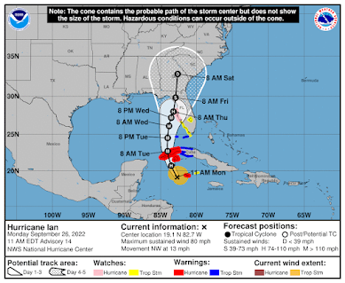
Hurricane Ian
Updated 9/28/22

Hurricane IAN is predicted to become a major hurricane.   The second of 2022's Atlantic Hurricane Season has formed and is expected to strengthen. Hurricane Ian is projected to bring a perilous storm surge and winds as strong as 140 mph when it nears Florida's Gulf Coast in the middle of this week, the National Hurricane Center said on Monday. Ian is expected to remain at or near major hurricane strength as it passes near the west-central coast of Florida on Wednesday and Thursday. 

State of Emergency Declarations

Florida Gov. Ron DeSantis declared a state of emergency for all of Florida on Saturday in preparation for Ian’s arrival this week, encouraging all residents to make preparations ahead of its arrival. 

President Joe Biden declared a state of emergency for Florida on Saturday as Tropical Storm Ian gained strength and barreled toward the Sunshine State. The declaration authorizes the Department of Homeland Security and FEMA to coordinate disaster relief efforts and provide assistance. 

Airline Waivers

Due to Ian’s expected arrival, several airlines have proactively issued travel waivers for those that could be impacted for both Florida and other Caribbean airports. If you are traveling to the region this week, check with your airline for latest cancellations or flight changes. 

In addition to possible delays to ship departures, cruisers scheduled to sail out of the central Florida ports of Port Canaveral and Tampa this week could face flight cancellations and delays.


Cruise Line Changes

Cruise lines headquarters are closely monitoring Hurricane Ian and staying in contact with their ships and the National Hurricane Center to keep crew, passengers, and ships out of harms way. During hurricane season, it is common to see itinerary changes which can include shortening or lengthening of cruises, rearranging of ports, changing complete itineraries (eg. from Western to Eastern Caribbean), or any other minor modification necessary to maintain safety. In addition, they are providing the National Hurricane Center with data to help determine conditions in the region. As changes are announced, we will update this page.  

(see below for latest updates)
 

Port Conditions (explanations)


CONDITION "WHISKEY" - The U.S. Coast Guard Captain of the Port (COTP) has set hurricane condition "WHISKEY" for Port Canaveral: Sustained gale force winds are predicted within 72 hours. Port Canaveral is currently fully open and conducting normal Port operations. Please ensure your businesses and homes are clear of any debris that may become projectiles in the wind. Please monitor Port Canaveral and https://twitter.com/BrevardEOC and the Port Status Hotline at 321-394-3411 for updates.


PortMiami is now in X-Ray condition due to Hurricane Ian. Read the bulletin.


PORT CONDITION YANKEE: Port Tampa Bay is monitoring Hurricane Ian


Port Everglades is currently under Port Condition X-RAY. Click the link below for more information. Read More


If you are sailing this week or next, please consult with your travel agent or the cruise line's website for up to the minute information.  The information below was accurate at the time of publication.
 
Hurricane IAN
800 AM EDT Wed Sep 28 2022

...IAN EXPECTED TO CAUSE CATASTROPHIC STORM SURGE, WINDS, AND 
FLOODING IN THE FLORIDA PENINSULA STARTING LATER TODAY...

WIND:
MAXIMUM SUSTAINED WINDS...155 MPH...250 KM/H
WATCHES/ WARNINGS:
SUMMARY OF WATCHES AND WARNINGS IN EFFECT:
A Hurricane Warning is in effect for...
* Chokoloskee to Anclote River, including Tampa Bay
* Dry Tortugas

A Storm Surge Warning is in effect for...
* Suwannee River southward to Flamingo
* Tampa Bay
* Lower Florida Keys from Big Pine Key westward to Key West
* Dry Tortugas
* Flagler/Volusia Line to the mouth of the St. Mary's River
* St. Johns River

A Tropical Storm Warning is in effect for...
* Cuban provinces of La Habana, Mayabeque, and Matanzas
* Indian Pass to the Anclote River
* All of the Florida Keys
* Flamingo to South Santee River
* Flamingo to Chokoloskee
* Lake Okeechobee
* Florida Bay
* Bimini and Grand Bahama Islands

A Storm Surge Watch is in effect for...
* Florida Keys from the Card Sound Bridge westward to east of Big
Pine Key
* Florida Bay
* Mouth of St. Mary's River to South Santee River


Click Here to Learn More


Royal Caribbean Itinerary Updates 
(click for latest)


  • Mariner of the Seas. The 3,344-passenger Royal Caribbean ship has skipped a call scheduled for Labadee, Haiti, on Monday and instead is at sea. The Port Canaveral, Florida-based ship is on a five-night voyage that began on Saturday. 
  • Liberty of the Seas. The 3,798-passenger Royal Caribbean ship will skip a call at Cozumel on Tuesday as it heads far more easterly than normal to avoid the storm. The ship is on a seven-night cruise out of Galveston, Texas. 
  • Allure of the Seas. The 5,484-passenger Royal Caribbean ship will skip a call at Roatan, Honduras, scheduled for Tuesday as it also stays to the east to avoid the storm. The ship is on a six-night voyage from Fort Lauderdale.


Follow @JamesVanFleet or visit the Royal Caribbean Facebook page for frequent updates.

Celebrity Cruises
(WEATHER UPDATE See latest advisories)
  • Celebrity Infinity. The 2,170-passenger Celebrity Cruises vessel pulled into Nassau in the Bahamas on Monday instead of being at sea as scheduled. It will skip a call in Belize on Tuesday and replace a call in Cozumel, Mexico, scheduled for Wednesday with a stop in Labadee, Haiti. The Fort Lauderdale-based vessel is on a seven-night voyage that began Saturday.


Disney Cruise Line Weather Alert (click for latest)

As of September 26, at 9:00 PM We are closely monitoring Hurricane Ian. Based on the current projected forecast, we anticipate that the Disney Wish, Disney Fantasy and Disney Dream will sail as scheduled. However, there is a possibility that the Disney Wish will return to Port Canaveral on Friday, September 30, later than originally scheduled. We will notify Guests should it be necessary to delay embarkation for the September 30 Disney Wish sailing.


MSC Cruises

  • MSC Seashore. 4,540-passenger MSC Seashore is also heading to the Eastern Caribbean instead of the Western Caribbean. The Miami-based vessel, which departed the city on Saturday, will visit the Bahamas and the Dominican Republic over the next few days instead of Jamaica, Grand Cayman and Mexico.


Norwegian Cruise Line Weather Alert (click for latest)

  • Norwegian Sky. 2,002-passenger Norwegian Sky was sent to the Eastern Caribbean for the week instead of the Western Caribbean to avoid the storm.

Carnival Cruise Line Travel Alerts (click for latest)

Among other vessels that could face disruptions are Carnival Cruise Line ships based in the Gulf of Mexico ports of Galveston; New Orleans; Mobile, Alabama; and Tampa, including Carnival Dream, Carnival Ecstasy, Carnival Glory and Carnival Paradise. The Port Canaveral-based Carnival Liberty also could be affected if Ian tracks eastward across Florida.

"Our fleet operations center in Miami is continuing to monitor Hurricane Ian and its potential impact on the itineraries for the following ships: Carnival Dream, Ecstasy, Glory, Liberty, Paradise and Sunrise," Carnival spokesperson Matt Lupoli said in a statement. 

Of particular concern is Carnival Paradise, the only cruise vessel currently based in Tampa. It's due back in Tampa early Thursday from a five-night cruise to the Western Caribbean and scheduled to depart the city later that day on a new voyage. The current projections for Hurricane Ian's track put it close to Tampa by Thursday.


Virgin Voyages

Scarlet Lady. The 2,770-passenger Virgin Voyages vessel will skip a call at Costa Maya, Mexico, scheduled for Tuesday and visit Puerto Plata in the Dominican Republic instead. The ship is on a five-night voyage out of Miami that began Saturday. 


Hurricane Season Dates 

Hurricane season in the Atlantic begins June 1st and ends November 30th. The Eastern Pacific hurricane season begins May 15th and also ends November 30th.
Make a Plan (FEMA) 


Read entire series (click here)


More links and information about tropical storms and other weather conditions can be found in the Weather & Hurricane Zone tabs above.


If you live in, or plan to vacation in, an area where hurricanes are prevalent, please prepare in advance by reading our series.


I recently completed extensive training and have become Travel Safety Verified. As your dedicated Travel Advisor, your safety is our priority, and it's our job to ensure you have the necessary information you need to give you confidence and peace of mind when making your future travel plans. Click the link to review our Travel Safety program with valuable resources that will answer many of your questions.


Where have you explored? 

Gather your travel and food pics and join us every Wednesday afternoon at 4 PM Eastern for the latest installment of #FoodTravelChat


Monday, September 19, 2022

Hurricane Fiona Impacts Cruise Ships

Hurricane Fiona

Archive | Graphics

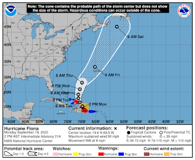
Hurricane Fiona
Updated 9/20/22


Hurricane Fiona is now a major Category 3 hurricane.  Hurricane Fiona left a wake of destruction including catastrophic flooding, widespread power outages, and mudslides, as it swamped Puerto Rico and the Dominican Republic on Sunday and Monday, resulting in multiple deaths and dozens of rescue operations. Turks and Caicos and the eastern Bahamas are the next areas expected to be hit, with the National Hurricane Center projecting an estimated 4-8 inches of rainfall. 

Fiona is moving toward the north-northwest near 9 mph (15 km/h). This general motion is expected to continue through today, followed by a turn toward the north tonight or Wednesday. On the forecast track, the center of Fiona will continue to move near the eastern Turks and Caicos during the next few hours, away from those islands by tomorrow, and approach Bermuda late on Thursday.
 
Several Cruise Lines have made changes to their itineraries in anticipation of the approaching hurricane.  Several ports are planning closures, which is part of the reason for the changes.
We have listed several changes below.

Airports in the region were also impacted with several of them closing or cancelling flights. This included Dominican Republic, St. Thomas, St. Croix, and Puerto Rico.  Some operations have resumed.  Businesses and airports will be closed in Turks and Caicos and the Bahamas on Tuesday and Wednesday.

If you are sailing this week or next, please consult with your travel agent or the cruise line's website for up to the minute information.  The information below was accurate at the time of publication.
 
Hurricane Fiona
1100 AM EDT Tue Sep 20 2022

...MAJOR HURRICANE FIONA CONTINUES TO BATTER THE TURKS AND CAICOS...
WIND:
MAXIMUM SUSTAINED WINDS...115 MPH...185 KM/H
WATCHES/ WARNINGS:
CHANGES WITH THIS ADVISORY...

None

SUMMARY OF WATCHES AND WARNINGS IN EFFECT:
 
A Hurricane Warning is in effect for...
* Turks and Caicos

A Tropical Storm Warning is in effect for...
* Southeastern Bahamas, including the Acklins, Crooked Island, Long
Cay, the Inaguas, Mayaguana, and the Ragged Islands


Click Here to Learn More


Royal Caribbean Itinerary Updates 
(click for latest)


Harmony of the Seas: 

Other than keeping its originally planned visit to Perfect Day at CocoCay, Harmony is swapping out its Eastern Caribbean sailing, which departed September 18, for a Western Caribbean itinerary. In place of port calls to St. Thomas and St. Maarten, the ship will visit Costa Maya and Cozumel.

Follow @JamesVanFleet or visit the Royal Caribbean Facebook page for frequent updates.


Disney Cruise Line Weather Alert (click for latest)

Disney Fantasy

Disney Fantasy is keeping a scheduled call to Castaway Cay on September 23, but otherwise swapping over from an Eastern Caribbean sailing to a Western Caribbean itinerary. Instead of visiting Tortola and St. Thomas, the ship will call on Cozumel on today, Grand Cayman on September 20, and Falmouth, Jamaica on September 21.

MSC Cruises

MSC Seashore: 

Like Disney and Royal Caribbean, MSC Cruises is keeping its scheduled stop in the Bahamas this week, but replacing the rest of MSC Seashore’s Eastern Caribbean itinerary with a Western Caribbean one. Instead of visiting Puerto Rico, St. Thomas and the Dominican Republic, the ship will make stops in Roatan (Honduras), Cozumel and Costa Maya. 


Norwegian Cruise Line Weather Alert (click for latest)

Norwegian Sky: 

Norwegian Sky’s scheduled Eastern Caribbean sailing, which departed Miami on September 18, has been switched to a Western Caribbean itinerary. In place of Puerto Plata, Dominican Republic, St. Thomas, Tortola and Great Stirrup Cay, the ship is stopping at Costa Maya, Roatan, Harvest Caye (Belize), and Cozumel.

Carnival Cruise Line Travel Alerts (click for latest)

Carnival Legend: 

Carnival Legend, which departed Baltimore on September 17 on an eight-day sailing, will visit Nassau in The Bahamas on Wednesday, September 21 instead of Grand Turk. On Thursday September 22, the ship was scheduled to visit Amber Cove in the Dominican Republic, but will now visit Bimini in The Bahamas, instead. 

Carnival Freedom: 

Carnival Freedom is currently on a five-day cruise out of Part Canaveral. On Tuesday, September 20, the ship will spend the day at sea instead of calling at Grand Turk. Instead of a day at sea on Wednesday, September 21, it will stop at Freeport, The Bahamas.


Virgin Voyages

Scarlet Lady: 

Scarlet Lady made one change to its scheduled itinerary. Instead of visiting Puerto Plata, Dominican Republic on Sunday, September 18, the ship instead called in at Costa Maya, Mexico.


Hurricane Season Dates 

Hurricane season in the Atlantic begins June 1st and ends November 30th. The Eastern Pacific hurricane season begins May 15th and also ends November 30th.
Make a Plan (FEMA) 


Read entire series (click here)


More links and information about tropical storms and other weather conditions can be found in the Weather & Hurricane Zone tabs above.


If you live in, or plan to vacation in, an area where hurricanes are prevalent, please prepare in advance by reading our series.


I recently completed extensive training and have become Travel Safety Verified. As your dedicated Travel Advisor, your safety is our priority, and it's our job to ensure you have the necessary information you need to give you confidence and peace of mind when making your future travel plans. Click the link to review our Travel Safety program with valuable resources that will answer many of your questions.


Where have you explored? 

Gather your travel and food pics and join us every Wednesday afternoon at 4 PM Eastern for the latest installment of #FoodTravelChat


Thursday, August 23, 2018

Hurricane Lane Alters Cruise Itinerary


Dangerous Hurricane Lane approaches the main Hawaiian Islands.  The Central Pacific Hurricane Center (CPHC) in Honolulu Hawaii predicts a slow northward motion to begin this afternoon and continue through Friday. A turn toward the west is expected Saturday and Sunday, with an increase in forward speed.

The latest forecast track from the Central Pacific Hurricane Center brings the center of Lane dangerously close to the main Hawaiian Islands Thursday afternoon through Saturday.

Regardless of the exact track, life threatening impacts are likely over many areas as this strong hurricane makes its closest approach. Do not focus on the exact forecast track or intensity of Lane. Be prepared for changes in future forecasts. Although the official forecast does not explicitly indicate Lane's center making landfall over any of the islands, this could still occur.

CPHC issuing advisories for the Central Pacific on LANE


Full coverage of this, and all tropical storms, can be found on our Hurricane Zone page.   There are RSS feeds from the National Hurricane Center posted there giving you up to the minute information.   For storms that impact cruises, we will bring you information on those details as well.  Please bookmark that page for further reference during the Hurricane Season which runs now through November 30th.


HURRICANE LANE
23 Aug 2018 11:13 am HST

...LANE MOVING NORTH-WESTWARD AS A POWERFUL CATEGORY 4 HURRICANE...
WIND:
near 130 mph with higher gusts
WATCHES/ WARNINGS:
Hurricane Watch:
 Kauai Leeward, Kauai Mountains, Kauai Windward, and Niihau 

Hurricane Warning: 
Big Island Interior, Big Island North and East, 

Big Island Summits, Central Oahu, Haleakala Summit, 

Kahoolawe, Kohala, Kona, Lanai Makai, Lanai Mauka, 

Leeward Haleakala, Maui Central Valley, Maui Leeward West, 

Maui Windward West, Molokai Leeward, Molokai Windward, 

Oahu Koolau, Oahu North Shore, Oahu South Shore, Olomana,

South Big Island, Waianae Coast, Waianae Mountains, 

and Windward Haleakala

SHIP IMPACT:
Pride of America - Hurricane Lane Update
August 23, 2018 at 9:30 PM ET (1:30 AM UTC) 


Due to Hurricane Lane in the Pacific, Norwegian Cruise Line has modified the itinerary for Pride of America. The ship is currently out at sea, away from the storm. Pride of America is expected to return to Honolulu on Sunday, August 26th.

The previously scheduled August 25th sailing will be delayed until Monday, August 27th. Embarkation will be available on both Sunday, August 26th and Monday, August 27th.  

Monitor the following link for the latest updates:

Norwegian: Weather Alert  


Saturday, September 16, 2017

Atlantic Basin Still Active


MORE INFORMATION ABOUT HURRICANES (CLICK HERE)

 
Tropical Storm Jose

The center of newly upgraded Hurricane Jose, at Sep 07/2100 UTC was near 13.9N 45.8W, or about 905 NM E of the Lesser Antilles. Jose was moving WNW, 285 degrees, at 15 knots. The estimated minimum central pressure was 994 mb. The maximum sustained wind speeds were 65 kt with gusts to 80 kt.  Today almost 10 days later, it is still a powerful Hurricane with its sights on the East Coast of the United States.  Life-threatening rip-currents are forecast along the coast.

JOSE AT A GLANCE

 
UPDATE
CAT 
WIND / MB
COMMENTS
8:00 AM AST 
Wed Sep 20 2017

TS  
65 MPH 100 KM/H
976 MB
...JOSE CONTINUES TO PRODUCE 
DANGEROUS SURF AND RIP
CURRENTS ALONG A LARGE 
PORTION OF THE U.S. EAST COAST...


Hurricane Lee

At 500 PM AST (Sep 16 2100 UTC), the center of Tropical Storm Lee was located near latitude 12.6 North, longitude 34.2 West. Lee is moving toward the west near 10 mph (17 km/h), and this motion is expected to continue through Sunday. A west-northwestward motion is expected Sunday night and Monday.

LEE AT A GLANCE
Storm Archive       Graphics Archive 
UPDATE
CAT 
WIND / MB
COMMENTS
5:00 PM AST 
Tue Sep 26 2017

2  
110 MPH 175 KM/H
971 MB
...LEE STILL INTENSIFYING, 
FORECAST TO BECOME A MAJOR 
HURRICANE BY EARLY WEDNESDAY...


Tropical Storm Maria 


For the second weekend in a row, we have three named storms in the Atlantic Basin. Tropical (5:00 PM AST Sat Sep 16) Depression 15 was just promoted to Tropical Storm Maria as it attained a wind speed of 50 MPH.
SUMMARY OF WATCHES AND WARNINGS IN EFFECT:

A Storm Surge Warning is in effect for...
* Ocracoke Inlet to Cape Hatteras

A Tropical Storm Warning is in effect for...
* Bogue Inlet to the North Carolina/Virginia border
* Albemarle and Pamlico Sounds

A Storm Surge Watch is in effect for...
* Cape Lookout to west of Ocracoke Inlet
* North of Cape Hatteras to Duck


MARIA AT A GLANCE
   Storm Archive       Graphics Archive 
 
UPDATE
CAT 
WIND / MB
COMMENTS
8:00 PM AST 
Tue Sep 26 2017

TS  
150 MPH 240 KM/H
921 MB
...MARIA PRODUCING GUSTY WINDS 
OVER THE OUTER BANKS OF NORTH
CAROLINA...


Hurricane Preparedness Mini-Series:


Sign-up for Exclusive Email Offers


Friday, August 25, 2017

Hurricane Harvey Closes Port of Galveston

 
Courtesy NHC - Click for More Graphics

HURRICANE HARVEY


Hurricane Harvey
800 AM CDT Fri Aug 25 2017

...8 AM CDT POSITION ESTIMATE...
...TROPICAL STORM FORCE WINDS NEARING THE COAST OF TEXAS...
WIND:
MAXIMUM SUSTAINED WINDS...110 MPH...175 KM/H
WATCHES/ WARNINGS:
SUMMARY OF WATCHES AND WARNINGS IN EFFECT:

A Storm Surge Warning is in effect for...
* Port Mansfield to High Islan
d Texas

A Storm Surge Watch is in effect for...
* South of Port Mansfield Texas to the Mouth of the Rio Grande

A Hurricane Warning is in effect for...
* Port Mansfield to Sargent Texas

A Tropical Storm Warning is in effect for...
* North of Sargent to High Island Texas
* South of Port Mansfield Texas to the Mouth of the Rio Grande

A Hurricane Watch is in effect for...
* South of Port Mansfield Texas to the Mouth of the Rio Grande

A Tropical Storm Watch is in effect for...
* South of the Mouth of the Rio Grande to Boca de Catan Mexico
SHIP IMPACT:
Carnival Cruise Line 
Disney Cruise Line
Royal Caribbean
Norwegian Cruise Line

Carnival & Royal are actively tracking Harvey 
     
Storm Archive       Graphics Archive

A Storm Surge Warning means there is a danger of life-threatening
inundation from rising water moving inland from the coastline in the
indicated locations. For a depiction of areas at risk, please see
the National Weather Service Storm Surge Watch/Warning Graphic,
available at hurricanes.gov.  This is a life-threatening situation.
Persons located within these areas should take all necessary actions
to protect life and property from rising water and the potential for
other dangerous conditions.  Promptly follow evacuation and other
instructions from local officials.

A Hurricane Warning means that hurricane conditions are expected
somewhere within the warning area, in this case within the next 12
to 24 hours. Preparations to protect life and property should be
rushed to completion.

A Storm Surge Watch means there is a possibility of life-
threatening inundation, from rising water moving inland from the
coastline, in the indicated locations during the next 48 hours.

A Hurricane Watch means that hurricane conditions are possible
within the watch area.

In addition, interests in southwestern Louisiana should continue to
monitor the progress of this system.


ITINERARY UPDATES August 27, 2017 Royal Caribbean International is diverting Liberty of the Seas to Miami until conditions at the Port of Galveston permit safe travel. Due to port closure because of Hurricane Harvey, Liberty was not able to make her scheduled arrival into Galveston today. We anticipate Liberty will be able to return to Galveston on Friday, conditions permitting. We are doing all we can to help guests adjust their travel arrangements and appreciate their patience as we work through this. The next sailing of Liberty of the Seas, scheduled for Sunday, August 27 has been cancelled, and all guests will have their fares fully refunded and have been provided a future cruise credit. If you have any questions, please do not hesitate to contact us at 1(866) 562-7625.
Carnival Cruise Line Advisory (click for latest alerts)


WEATHER UPDATE #3 – 08/25/17 – 1:00 PM (EST)

Carnival Valor and Carnival Freedom are currently keeping a safe distance from the storm as they make their way back to Galveston.

Carnival Breeze is currently docked in Cozumel and will now overnight there. The ship will depart for Galveston tomorrow afternoon to be in position to debark guests when the port reopens. The Port of Galveston is closed to all marine traffic. It is expected to remain closed until the storm has passed and a port assessment has been completed.

Please do not proceed to the cruise terminal until you have heard from us. Our intention is to dock in Galveston as soon as port officials have reopened the port. The duration of your cruise will have to be shortened and the itinerary modified. Cruise details will be finalized once we have confirmed our arrival into Galveston.

Guests who sail will receive a pro-rated refund of their cruise fare for missed days and refund of any pre-purchased Carnival Adventures for canceled ports. Additionally, guests who pre-purchased any of our beverage packages will receive a pro-rated refund. Gratuities will also be adjusted to reflect the shortened duration.

We certainly understand the impact Hurricane Harvey is having on your cruise plans. Should you wish to cancel and receive a future cruise credit, please call 1-800-CARNIVAL, contact your Personal Vacation Planner at 1-800-819-3902, or your travel agent.

4 Things To Help Plan Vacation in Hurricane Season

We continue to actively monitor the storm and will update you tomorrow at 3:00PM CDT.

To stay up to date on any changes, guests are asked to sign up for text alerts by texting the codes below to CRUISE (278473).

Carnival Freedom 08/26/17 - CCL1
Carnival Valor 08/26/17 - CCL2
Carnival Breeze 08/27/17 - CCL3


Hurricane Preparedness Mini-Series: