Showing posts with label East Pacific. Show all posts

Monday, June 3, 2019

NOAA 2019 Hurricane Predictions

Credit NOAA (click to enlarge)

Predictions for 
2019 Hurricane Season


We've already provided you with Colorado State University's April Prediction for the Atlantic Basin.  NOAA has just released its predictions for the Atlantic Basin, Central and East Pacific regions.


Looking Back and Looking Ahead
Hurricane Season Approaching 

Looking Back at 2018

The 2018 Atlantic hurricane season  was the third in a consecutive series of above-average and damaging hurricane seasons, featuring 17 named storms, 10 hurricanes and 6 major hurricanes. The season will be best remembered for Hurricanes Florence and Michael, which caused significant damage in the Southeastern United States. 2018 was the first season since 2008 to feature four named storms active simultaneously (Florence, Helene, Isaac, and Joyce). The season also was the first on record to see seven storms that were subtropical at some point in their lifetimes (Alberto, Chris, Debby, Ernesto, Joyce, Leslie, and Oscar).

In the chart below, the numbers in parenthesis are the averages, so you can easily see that the 2018 Atlantic Hurricane Season was well above average.  For more details, read  NOAA: Destructive 2018 Atlantic hurricane season draws to an end.


Atlantic Basins

Forecast Parameter and 1950-2000
Climatology (in parentheses)
NOAA 2018
Prediction
2018
Actual
Named Storms (NS) (12.0)10 - 1615
Hurricanes (H) (6.5)5 - 98
Major Hurricanes (MH) (2.0)1 - 42
Accumulated Cyclone Energy (ACE) (92.0)63 - 145133


Atlantic Hurricane Outlook & Seasonal Climate Summary Archive

The 2018 Pacific hurricane season produced the highest accumulated cyclone energy (ACE) value on record. With 23 named storms, it was the fourth-most active season on record, tied with 1982.

East Pacific


Forecast Parameter and 1950-2000
Climatology (in parentheses)
NOAA 2018
Prediction
2018
Actual
Named Storms (NS) (9.6)14 - 2023
Hurricanes (H) (5.9)7- 1213
Major Hurricanes (MH) (2.3)3 - 710
Accumulated Cyclone Energy (ACE) (96.1) 80 - 160202

Looking Ahead to 2018


As is customary, the Colorado State University releases its predictions in December and April. See our blog post,  2019 CSU Atlantic Hurricane Prediction, for their 2019 predictions.


click to enlarge


Forecasters predict a 40% chance of a near-normal season, a 30% chance of an above-normal season and a 30% chance of a below-normal season for the upcoming hurricane season, which extends from June 1 to November 30.

NOAA’s forecasters predict a 70-percent likelihood of 9 to 15 named storms (winds of 39 mph or higher), of which 4 to 8 could become hurricanes (winds of 74 mph or higher), including 2 to 4 major hurricanes (category 3, 4 or 5; with winds of 111 mph or higher). An average hurricane season produces 12 named storms, of which 6 become hurricanes, including 3 major hurricanes.

East Pacific

An 80 percent chance of a near- or above-normal season is predicted for both the eastern and central Pacific regions. The eastern Pacific outlook calls for a 70-percent probability of 14 to 20 named storms, of which 7 to 12 are expected to become hurricanes, including 3 to 7 major hurricanes.

Central Pacific

The central Pacific outlook calls for a 70-percent probability of 5 to 8 tropical cyclones, which includes tropical depressions, tropical storms and hurricanes.

Measuring total seasonal activity: The Accumulated Cyclone Energy (ACE) index

ACE - Atlantic / Pacific

click images to enlarge


An important measure of the total overall seasonal activity is the NOAA Accumulated Cyclone Energy (ACE) index, which accounts for the intensity and duration of named storms and hurricanes during the season.  According to NOAA’s hurricane season classifications, an ACE value above 117% of the 1950-2000 median reflects an above-normal season. An ACE value above 175% of the median reflects an exceptionally active (or hyperactive) season.

Hurricane Season Dates 

Hurricane season in the Atlantic begins June 1st and ends November 30th. The Eastern Pacific hurricane season begins May 15th and also ends November 30th.
Make a Plan (FEMA) 


Read entire series (click here)

More links and information about tropical storms and other weather conditions can be found in the Weather & Hurricane Zone tabs above.


If you live in, or plan to vacation in, an area where hurricanes are prevalent, please prepare in advance by reading our series.

Thursday, May 31, 2018

NOAA 2018 Hurricane Predictions

Credit NOAA (click to enlarge)

Predictions for 
2018 Hurricane Season


We've already provided you with Colorado State University's April Prediction for the Atlantic Basin.  NOAA has just released its predictions for the Atlantic Basin, Central and East Pacific regions.


Looking Back and Looking Ahead
Hurricane Season Approaching 

Looking Back at 2017

The 2017 Atlantic hurricane season was a hyperactive and catastrophic hurricane season, featuring 17 named storms, 10 hurricanes and 6 major hurricanes – ranking it alongside 1936 as the fifth-most active season since records began in 1851. The season also featured both the highest total accumulated cyclone energy (ACE) and the highest number of major hurricanes since 2005.

In the chart below, the numbers in parenthesis are the averages, so you can easily see that the 2017 Atlantic Hurricane Season was well above average.  For more details, read  NOAA: Extremely active 2017 Atlantic hurricane season finally ends


Atlantic Basins

Forecast Parameter and 1950-2000
Climatology (in parentheses)
NOAA 2017
Prediction
2017
Actual
Named Storms (NS) (12.0)11 - 1717
Hurricanes (H) (6.5)5 - 910
Major Hurricanes (MH) (2.0)2 - 46
Accumulated Cyclone Energy (ACE) (92.0)63 - 103224

Atlantic Hurricane Outlook & Seasonal Climate Summary Archive


The 2017 Pacific hurricane season was a moderately active Pacific hurricane season, featuring eighteen named storms, nine hurricanes, and four major hurricanes, though the season was significantly less active than the previous three seasons. The season saw near-average activity in terms of ACE, in stark contrast to the extremely active seasons in 2014, 2015, and 2016; and for the first time since 2012, no tropical cyclones formed in the Central Pacific basin. However, for the third year in a row, the season featured above-average activity in July, with the ACE value being the fifth highest for the month.

East Pacific


Forecast Parameter and 1950-2000
Climatology (in parentheses)
NOAA 2017
Prediction
2017
Actual
Named Storms (NS) (9.6)14 - 2018
Hurricanes (H) (5.9)6 - 119
Major Hurricanes (MH) (2.3)3 - 74
Accumulated Cyclone Energy (ACE) (96.1) 75 - 145100

Looking Ahead to 2018


As is customary, the Colorado State University releases its predictions in December and April. See our blog post,  2018 CSU Atlantic Hurricane Prediction, for their 2018 predictions.


(click images to enlarge)  Credit NOAA


Forecasters predict a 35 percent chance of an above-normal season, a 40 percent chance of a near-normal season, and a 25 percent chance of a below-normal season for the upcoming hurricane season, which extends from June 1 to November 30.

NOAA’s forecasters predict a 70-percent likelihood of 10 to 16 named storms (winds of 39 mph or higher), of which 5 to 9 could become hurricanes (winds of 74 mph or higher), including 1 to 4 major hurricanes (category 3, 4 or 5; with winds of 111 mph or higher). An average hurricane season produces 12 named storms, of which 6 become hurricanes, including 3 major hurricanes.

East Pacific

An 80 percent chance of a near- or above-normal season is predicted for both the eastern and central Pacific regions. The eastern Pacific outlook calls for a 70-percent probability of 14 to 20 named storms, of which 7 to 12 are expected to become hurricanes, including 3 to 7 major hurricanes.

Central Pacific

The central Pacific outlook calls for a 70-percent probability of 3 to 6 tropical cyclones, which includes tropical depressions, tropical storms and hurricanes.

Measuring total seasonal activity: The Accumulated Cyclone Energy (ACE) index

ACE - Atlantic / Pacific

click images to enlarge


An important measure of the total overall seasonal activity is the NOAA Accumulated Cyclone Energy (ACE) index, which accounts for the intensity and duration of named storms and hurricanes during the season.  According to NOAA’s hurricane season classifications, an ACE value above 117% of the 1950-2000 median reflects an above-normal season. An ACE value above 175% of the median reflects an exceptionally active (or hyperactive) season.

Hurricane Season Dates 

Hurricane season in the Atlantic begins June 1st and ends November 30th. The Eastern Pacific hurricane season begins May 15th and also ends November 30th.
Make a Plan (FEMA) 

Read entire series (click here)


More links and information about tropical storms and other weather conditions can be found in the Weather & Hurricane Zone tabs above.


Hurricane Preparedness Week:   
May 6-12, 2018
@ChrisPappinMCC


Follow Us On


Sign-up for Exclusive Email Offers


Saturday, May 28, 2016

NOAA 2016 Hurricane Predictions

Credit NOAA
Predictions for 
2016 Hurricane Season

We've already provided you with Colorado State University's April Prediction for the Atlantic Basin.  NOAA has just released its predictions for the Atlantic Basin, Central and East Pacific regions.


  • NOAA: Near-normal Atlantic Hurricane Season is likely this year 
  • NOAA: Predicts Near-normal Eastern Pacific Hurricane Season
  • NOAA Predicts an above-normal Central Pacific hurricane season

Looking Back and Looking Ahead
Hurricane Season Approaching 
NEAR-NORMAL ATLANTIC PREDICTED

NOAA's Climate Prediction Center (CPC) had predicted an below-normal season which is what actually resulted.  The 2015 Atlantic hurricane season was a below average Atlantic hurricane season that produced eleven named storms, four hurricanes and two major hurricanes.

Looking Back at 2015

In the chart below, the numbers in parenthesis are the averages, so you can easily see that the 2015 Atlantic Hurricane Season was slightly below average.  

Atlantic Basin
Forecast Parameter and 1950-2000
Climatology (in parentheses)
NOAA 2015
Prediction
2015
Actual
Named Storms (NS) (12.0) 6 - 11 11
Hurricanes (H) (6.5)3 - 64
Major Hurricanes (MH) (2.0) 0 - 2 2
Accumulated Cyclone Energy (ACE) (92.0)  40 - 85 63

Atlantic Hurricane Outlook & Seasonal Climate Summary Archive


The 2015 Eastern Northern Pacific Hurricane Season was well above average with the number of named storms more than double the average.  Hurricanes exceeded the top estimate, and there were 10 major hurricanes.  The Accumulated Cyclone Energy (ACE) was well above normal.  The Central Pacific was also active with 8 tropical storms with 3 hurricanes, of which 1 was a major storm.

East Pacific

Forecast Parameter and 1950-2000
Climatology (in parentheses)
NOAA 2015
Prediction
2015
Actual
Named Storms (NS) (9.6) 15-22 18
Hurricanes (H) (5.9)7 - 1213
Major Hurricanes (MH) (2.3) 5-8 10
Accumulated Cyclone Energy (ACE) (96.1)  110-190 250


Looking Ahead to 2016


As is customary, the Colorado State University releases its predictions in December and April. See our blog post,  2016 CSU Atlantic Hurricane Prediction, for their 2016 predictions.

Atlantic Basin


Forecast Parameter and 1950-2000
Climatology (in parentheses)
NOAA 2016
Prediction
CSU 2016
Prediction
Named Storms (NS) (12.0) 10-16 12
Hurricanes (H) (6.5)3-85
Major Hurricanes (MH) (2.0) 1-4 2
Accumulated Cyclone Energy (ACE) (92.0) 65-140 90

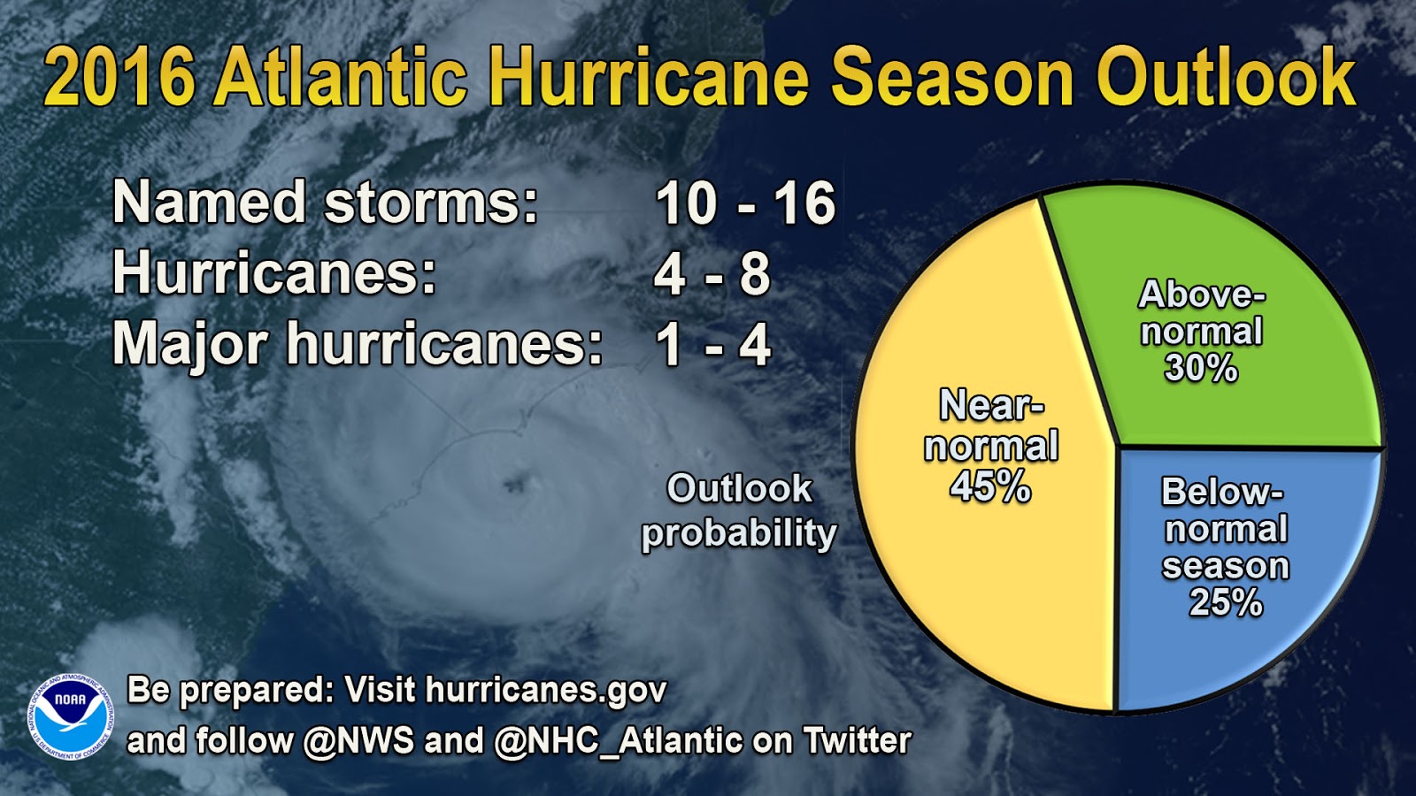
NOAA’s 2016 Atlantic Hurricane Season Outlook calls for a 45% chance of a near-normal season, a 30% chance of an above-normal season, and a 25% chance of a below-normal season.  For the six-month hurricane season, which begins June 1, NOAA predicts a 70 percent likelihood of 10 to 16 named storms (winds of 39 mph or higher), of which 4 to 8 could become hurricanes (winds of 74 mph or higher), including 1 to 4 major hurricanes (Category 3, 4 or 5; winds of 111 mph or higher). 
The outlook also calls for an Accumulated Cyclone Energy (ACE) range of 65%-140% of the median, which includes Alex in January
East Pacific

Forecast Parameter and 1950-2000
Climatology (in parentheses)
NOAA 2016
Prediction
Named Storms (NS) (9.6) 13-20
Hurricanes (H) (5.9)7 - 12
Major Hurricanes (MH) (2.3) 3-6
Accumulated Cyclone Energy (ACE) (96.1) 70-140


NOAA’s 2015 Eastern Pacific Hurricane Season Outlook is calling for a 70 percent chance of 15 to 22 named storms, which includes 7 to 12 hurricanes, of which 5 to 8 are expected to become major hurricanes (Category 3, 4 or 5 on the Saffir-Simpson Hurricane Wind Scale).  The outlook calls for a 70% chance of an above-normal season, a 25% chance of a near-normal season, and only a 5% chance of a below normal season.

Measuring total seasonal activity: The Accumulated Cyclone Energy (ACE) index

An important measure of the total overall seasonal activity is the NOAA Accumulated Cyclone Energy (ACE) index, which accounts for the intensity and duration of named storms and hurricanes during the season.  According to NOAA’s hurricane season classifications, an ACE value above 117% of the 1950-2000 median reflects an above-normal season. An ACE value above 175% of the median reflects an exceptionally active (or hyperactive) season.
Hurricane Season Dates 

Hurricane season in the Atlantic begins June 1st and ends November 30th. The Eastern Pacific hurricane season begins May 15th and also ends November 30th.
Download the Tropical Cyclone Preparedness Guide (PDF) 


Read Entire Series (click here)
Hurricane Preparedness Week came early this year. As usual we published a series of articles during that week.  Click on the image or link to the right to view the entire series.  

We have been covering hurricane preparedness for years, so if you still need more information, you can check out some of our other articles which can be found via links in our Hurricane Zone page.


Friday, October 23, 2015

Patricia Strongest Hurricane Recorded Impacts Cruises & Ports

Other images: 5-Day track off – 3-Day track off 


Hurricane Patricia
UPDATE: OCT 24

Hurricane Patricia made landfall at the speed of 165 MPH and then quickly began to weaken.  Early reports indicated that it would not be as catastrophic as predicted, fortunately.   We have gotten word that AM Resorts and the airport in Puerto Vallarta has reopened for example, so that is very good news.   

Emergency Message for U.S. Citizens: Hurricane Patricia Dated: October 24, 2015

~~~~~~~~

The largest hurricane to ever assault the Western Hemisphere headed toward Mexico’s southwest Pacific coast on Friday with 200 MPH winds. Patricia was expected to make landfall by early evening, according to Mexico’s national weather service, with the eye passing along the small beach towns of Playa Perula and Playa Chamela, both in the state of Jalisco. The government of Mexico declared a state of emergency in dozens of municipalities in the states of Colima, Nayarit and Jalisco.

Hurricane Patricia is expected to remain a Category 5 hurricane until landfall in southwestern Mexico in a few hours. After landfall, a combination of the mountainous terrain of Mexico and increasing shear should cause the cyclone to rapidly weaken, with the system likely to dissipate completely after 36 hours, if not sooner.

NHC issuing advisories for the Eastern Pacific on Hurricane PATRICIA
CPHC issuing advisories for the Central Pacific on OLAF
 

Full coverage of this, and all tropical storms, can be found on our Hurricane Zone page.   There are RSS feeds from the National Hurricane Center posted there giving you up to the minute information.   For storms that impact cruises, we will bring you information on those details as well.  Please bookmark that page for further reference during the Hurricane Season which runs now through November 30th.


HURRICANE PATRICIA
400 PM CDT FRI OCT 23 2015

...POTENTIALLY CATASTROPHIC HURRICANE PATRICIA SHOULD MAKE
LANDFALL IN MEXICO IN THE NEXT SEVERAL HOURS...
WIND:
190 MPH...305 KM/H with higher gusts
WATCHES/ WARNINGS:
A Hurricane Warning is in effect for...
* San Blas to Punta San Telmo

A Hurricane Watch is in effect for...
* East of Punta San Telmo to Lazaro Cardenas

A Tropical Storm Warning is in effect for...
* East of Punta San Telmo to Lazaro Cardenas
* North of San Blas to El Roblito
 
SHIP IMPACT:
Princess Cruises cancelled  Ruby Princess'scheduled call 
at Cabo San Lucas Friday, October 23, due to swells. The
 ship will return to Los Angeles Sunday, October 25, as scheduled.
 
A Hurricane Warning means that hurricane conditions are expected
somewhere within the warning area.  A warning is typically issued
36 hours before the anticipated first occurrence of
tropical-storm-force winds, conditions that make outside
preparations difficult or dangerous.  Preparations to protect life
and property should be rushed to completion.
 
A Hurricane Watch means that hurricane conditions are possible
within the watch area.  A watch is typically issued 48 hours
before the anticipated first occurrence of tropical-storm-force
winds, conditions that make outside preparations difficult or
dangerous.
     
A Tropical Storm Warning means that tropical storm conditions are
expected somewhere within the warning area within 36 hours.

A Tropical Storm Watch means that tropical storm conditions are
possible within the watch area, generally within 48 hours.


MORE INFORMATION ABOUT HURRICANES (CLICK HERE)

HAZARDS AFFECTING LAND

WIND:  Hurricane conditions should spread across the hurricane
warning area during the next few hours, with the worst conditions
occurring near where the eye of Patricia makes landfall.  Tropical
storm conditions are spreading across portions of the warning area.
Preparations to protect life and property should be rushed to
completion.  Hurricane conditions are possible in the hurricane
watch area this afternoon and this evening.

RAINFALL:  Patricia is expected to produce total rainfall
accumulations of 8 to 12 inches, with isolated maximum amounts of 20
inches, over the Mexican states of Nayarit, Jalisco, Colima,
Michoacan, and Guerrero through Saturday.  These rains could produce
life-threatening flash floods and mud slides.

STORM SURGE:  An extremely dangerous storm surge is expected to
produce significant coastal flooding near and to the right of where
the center makes landfall.  Near the coast, the surge will be
accompanied by large and destructive waves.

SURF:  Swells generated by Patricia are already affecting portions
of the southern coast of Mexico, and will spread northwestward
during the next day or so.  These swells are likely to cause
life-threatening surf and rip current conditions.  Please consult
products from your local weather office.


HISTORICAL NOTES

1000 AM CDT TUE OCT 20 2015

...TROPICAL DEPRESSION FORMS SOUTH OF THE GULF OF TEHUANTEPEC...
...EXPECTED TO STRENGTHEN...
 
1000 PM CDT TUE OCT 20 2015

...DEPRESSION STRENGTHENS INTO THE SIXTEENTH TROPICAL STORM OF
THE SEASON SOUTH OF MEXICO... 
 
400 PM CDT WED OCT 21 2015

...NOAA PLANE FINDS PATRICIA STRONGER AND FARTHER WEST...
...HURRICANE WARNING ISSUED FOR THE COAST OF MEXICO...
 
400 AM CDT THU OCT 22 2015

...PATRICIA CONTINUES TO STRENGTHEN...
...LIKELY TO BECOME A MAJOR HURRICANE LATER TODAY...
 
100 PM CDT THU OCT 22 2015

...NOAA HURRICANE HUNTERS FIND PATRICA IS AN EXTREMELY DANGEROUS
CATEGORY FOUR HURRICANE...
...PREPARATIONS SHOULD BE RUSHED TO COMPLETION IN THE HURRICANE
WARNING AREA TODAY...
 
1230 AM CDT FRI OCT 23 2015

...CATEGORY 5 HURRICANE PATRICIA STRENGTHENS EVEN MORE...
...POTENTIALLY CATASTROPHIC LANDFALL IN SOUTHWESTERN MEXICO LATER
TODAY...
 
1000 AM CDT FRI OCT 23 2015

...POTENTIALLY CATASTROPHIC HURRICANE PATRICIA MOVING NORTHWARD
TOWARD LANDFALL IN SOUTHWESTERN MEXICO...


Saturday, June 13, 2015

CARLOS Third Hurricane 2015 East Pacifc

Hurricane Carlos
Other images: 5-Day track off – 3-Day track off – 3-Day track on – Interactive

Hurricane  CARLOS

Tropical Depression Three-E formed Wednesday, well south of southwest Mexico and was upgraded to a Tropical Storm on Thursday.  Today (Saturday) it has become the third Hurricane of  the East Pacific 2015 Hurricane Season. Hurricane Carlos is forecast to strengthen a bit more, but will likely remain a Category 1 hurricane.

NHC issuing advisories on Hurricane CARLOS


Full coverage of this, and all tropical storms, can be found on our Hurricane Zone page.   There are RSS feeds from the National Hurricane Center posted there giving you up to the minute information.   For storms that impact cruises, we will bring you information on those details as well.  Please bookmark that page for further reference during the Hurricane Season which runs now through November 30th.


HURRICANE CARLOS
...HURRICANE HUNTER AIRCRAFT FINDS CARLOS HAS REGAINED HURRICANE
STATUS JUST OFFSHORE OF THE SOUTH-CENTRAL COAST OF MEXICO...
WIND:
75 mph (120 km/h) with higher gusts
WATCHES/ WARNINGS:
A Hurricane Watch is in effect for...
* West of Punta San Telmo to Playa Perula

A Tropical Storm Warning is in effect for...
* Punta San Telmo to Lazaro Cardenas

Interests elsewhere along the southwest coast of Mexico should
monitor the progress of Carlos.

SHIP IMPACT:
NO IMPACT REPORTED AT THIS TIME
 

A Hurricane Warning means that hurricane conditions are expected
somewhere within the warning area.  A warning is typically issued
36 hours before the anticipated first occurrence of
tropical-storm-force winds, conditions that make outside
preparations difficult or dangerous.  Preparations to protect life
and property should be rushed to completion.
 
A Hurricane Watch means that hurricane conditions are possible
within the watch area.  A watch is typically issued 48 hours
before the anticipated first occurrence of tropical-storm-force
winds, conditions that make outside preparations difficult or
dangerous.
     
A Tropical Storm Warning means that tropical storm conditions are
expected somewhere within the warning area within 36 hours.

A Tropical Storm Watch means that tropical storm conditions are
possible within the watch area, generally within 48 hours.

Storm Archive       Graphics Archive


MORE INFORMATION ABOUT HURRICANES (CLICK HERE)

HAZARDS AFFECTING LAND

WIND:  Tropical Storm conditions are expected within the warning
area today.  Hurricane conditions are possible within the hurricane
watch area by Tuesday morning.

RAINFALL:  Carlos is expected to produce rains in the Mexican states
of Guerrero, Michoacan, Colima, Jalisco and Nayarit, with rainfall
accumulations of 6 to 10 inches possible through Wednesday, and
maximum totals of 15 inches possible.  These rains may produce life-
threatening flash floods and mudslides, especially in areas of
higher terrain.

SURF:  Swells associated with Carlos will affect the coasts of
southern and southwestern Mexico during the next few days.  These
swells could cause life-threatening surf and rip currents.  Please
consult products from your local weather office.

HISTORICAL NOTES
 

400 PM CDT WED JUN 10 2015

...NEW TROPICAL DEPRESSION FORMS TO THE SOUTH OF MEXICO...

1000 AM CDT THU JUN 11 2015

...TROPICAL STORM CARLOS FORMS SOUTH OF MEXICO...

1000 AM CDT SAT JUN 13 2015

...HURRICANE WATCH AND TROPICAL STORM WARNING ISSUED FOR
PARTS OF SOUTHWESTERN MEXICO...

1000 AM CDT SUN JUN 14 2015

...CARLOS WEAKENS TO A TROPICAL STORM JUST SOUTH OF MEXICO...
...EXPECTED TO RESTRENGTHEN INTO A HURRICANE BY MONDAY...


100 PM CDT MON JUN 15 2015

...HURRICANE HUNTER AIRCRAFT FINDS CARLOS HAS REGAINED HURRICANE
STATUS JUST OFFSHORE OF THE SOUTH-CENTRAL COAST OF MEXICO...