Wednesday, September 29, 2010

Tropical Storm Nicole Produces Heavy Rains

TAFB Experimental Graphicast 9/29/10
NICOLE - SHORTEST TROPICAL STORM
 THIS SEASON

Last NHC advisory issued on NICOLE

Nicole is the shortest tropical storm of this season - lasting only six hours after being named.  It wasn't your typical storm with well-formed circular center; instead it was elongated.

Tropical Depression Sixteen formed over the Northwestern Caribbean Sea on Tuesday, September 28th around 11 AM EDT prompting tropical storm warnings for Florida, Cayman Islands, Cuba, and the Bahamas.  The storm has already dissipated and the NHC has issued its last advisory.  Heavy rains and wind are still expected.

UPDATE:  500 PM EDT WED SEP 29 2010
 ...NICOLE DISSIPATES OVER THE STRAITS OF FLORIDA...LARGE AREA OF
HEAVY RAINS PERSISTS... 
 

 THE GOVERNMENTS OF CUBA...GRAND CAYMAN...AND THE BAHAMAS HAVE DISCONTINUED ALL TROPICAL STORM WARNINGS.

MAXIMUM SUSTAINED WINDS ARE NEAR 40 MPH...65 KM/HR...WITH HIGHER
GUSTS.  WINDS ASSOCIATED WITH THE REMNANTS OF NICOLE SHOULD
GRADUALLY SUBSIDE...BUT A STRONG NON-TROPICAL LOW PRESSURE SYSTEM
WITH GALE FORCE WINDS IS EXPECTED TO DEVELOP NEAR THE SOUTHEAST
U.S. COAST TONIGHT.
 
TROPICAL STORM FORCE WINDS EXTEND OUTWARD UP TO 345 MILES...555 KM
TO THE SOUTHEAST OF THE CENTER.
 
ESTIMATED MINIMUM CENTRAL PRESSURE IS 996 MB...29.41 INCHES. 
 
 
HAZARDS AFFECTING LAND
 
RAINFALL...NICOLE IS EXPECTED TO PRODUCE TOTAL RAIN ACCUMULATIONS OF
5 TO 10 INCHES OVER THE CAYMAN ISLANDS...JAMAICA...AND CUBA.
ISOLATED MAXIMUM AMOUNTS OF 20 INCHES ARE POSSIBLE OVER THE HIGHER
ELEVATIONS OF CUBA AND JAMAICA.  THESE RAINS COULD CAUSE
LIFE-THREATENING FLASH FLOODS AND MUD SLIDES.  STORM TOTAL RAIN
ACCUMULATIONS OF 5 TO 10 INCHES ARE POSSIBLE OVER PORTIONS OF
SOUTHERN FLORIDA...THE FLORIDA KEYS...AND THE CENTRAL AND 
NORTHWEST BAHAMAS.
 
WIND...WINDS TO TROPICAL STORM FORCE ARE POSSIBLE OVER EASTERN
CUBA...THE CENTRAL AND NORTHWEST BAHAMAS...AND ADJACENT WATERS
TONIGHT. 
  
THIS IS THE LAST PUBLIC ADVISORY ISSUED BY THE NATIONAL HURRICANE
CENTER ON THIS SYSTEM.  ALTHOUGH NICOLE HAS DISSIPATED...THE
HYDROMETEOROLOGICAL PREDICTION CENTER IN WASHINGTON DC IS ISSUING
STORM SUMMARIES ON THE DEVELOPING NON-TROPICAL LOW UNDER AWIPS
HEADER NFDSCCNS5 AND WMO HEADER ACUS45 KWBC.  ADDITIONAL
INFORMATION CAN ALSO BE FOUND IN HIGH SEAS FORECASTS ISSUED BY THE
NATIONAL WEATHER SERVICE... UNDER AWIPS HEADER NFDHSFAT1 AND WMO
HEADER FZNT01 KWBC.

Oceania Cruises Double Bonus Alaska 2011

 See Alaska by Small Ship

 Oceania Cruises inaugural season in Alaska is currently open for bookings.   To kick off the traditional start of the selling season, they have announced a Double Bonus Savings Offer.


“We are offering our best fares ever on our inaugural Alaska sailings as we kick-off the traditional Alaska selling season,” stated Bob Binder, president of Oceania Cruises. “We have a long-standing tradition of offering the best fares and promotions up-front to reward our loyal guests and encourage them to book their preferred voyage and accommodations as early as possible.”

Travelers will discover Alaska aboard Oceania Cruises’ 684-guest Regatta – an intimate ship known for its gourmet cuisine, luxurious public rooms and accommodations, and attentive service. As a special highlight, Pacific Northwest specialties will be featured during lunch in the casual Terrace CafĂ© and in the ship’s elegant Grand Dining Room. Regional specialties will also be showcased in all four of the ship’s open-seating restaurants; all of which are available with no surcharge. 

 
ALASKA DOUBLE BONUS SAVINGS OFFER

Oceania Cruises has announced Double Bonus Savings on 10 exciting, new voyages for summer 2011. The limited-time promotion offers per stateroom savings of $1,000 off cruise fares plus a $1,000 shipboard credit on top of two-for-one prices and free airfare. In addition, third and fourth guests in a stateroom may travel for only $999 per person, cruise-only.

Depending on the cruise, scenic highlights encompass Hubbard Glacier, the Gulf of Alaska, Tracy Arm and College Fjord. With two-for-one cruise fares and Double Bonus Savings, a 10-day Alaska cruise starts at just $2,999 per person, based on double occupancy. This special offer expires Dec. 31, 2010.

A DISTINCTLY DIFFERENT ALASKAN EXPERIENCE
  • Each of our cruises presents a complete Alaska experience
  • One or Two Full Days of Glacier Cruising
  • Unique, off the beaten path ports combined with Alaska's star destinations
  • Intimate, mid-sized ships that are the perfect size for exploring Alaska
  • The finest cuisine at sea, including unique Pacific Northwest specialties
Known for its award-winning itineraries to the world’s most alluring ports, Oceania Cruises inaugural Alaska cruises explore the Inside Passage in depth. Itinerary highlights include at least one full day exploring the Inside Passage and one or two complete days of glacier viewing on every cruise, as well as a mix of marquee as well as off-the-beaten-path ports. In addition to Sitka, Skagway, Juneau and Ketchikan, itineraries feature quaint, less-visited outposts, such as Kodiak, Homer and Hoonah.

Choose From Four Intriguing Itineraries
  • Majestic Alaska – 14 days roundtrip from San Francisco, a maiden port for Oceania Cruises, visiting Victoria and Vancouver, British Columbia; Sitka, Hoonah, Skagway, Juneau and Ketchikan, Alaska; and Astoria, Ore. Departures: May 12, Aug. 26.
  • Alaskan Grandeur – 12 days between San Francisco and Vancouver. Ports include Astoria and Victoria, as well as Wrangell, Juneau, Hoonah, Sitka and Ketchikan. Departures: May 26, Aug. 14.
  • Frontiers and Glaciers – 10 days roundtrip from Vancouver, calling at Sitka, Hoonah, Kodiak, Wrangell and Ketchikan. Departures: June 7, Aug. 4.
  • Glacial Wilderness – 12 days between Vancouver and Anchorage, with visits to Ketchikan, Wrangell, Juneau, Hoonah, Skagway, Sitka, Seward and Homer. Departures: June 17 and 29, July 11 and 23.

Royal Caribbean WOW Sale Now in Progress

How WoulGed You Like 
Some Free Money?

For two days only, Royal Caribbean is giving out FREE money with every 2011 sailing booked during this WOW sale.


Getting free money couldn't be much easier.  If you have been considering a Royal Caribbean cruise after January 1, 2011, you can reserve your cruise during this sale and receive up to $200 per cabin in an onboard credit (click the link above for details and terms).   

Another benefit from this WOW sale is REDUCED DEPOSITS.   Lock in today's prices on the best available cabins and only put a deposit of 50% of the required amount.   This means that even if you are short on cash at the present time, you can still plan your cruise for next year and have plenty of time to make payments before the final payment is due.

If that isn't enough incentive,  this offer includes the newest and largest ships afloat ...  Oasis of the Seas and the brand new Allure of the Seas.   Search for your Royal Caribbean cruise here

EXCLUSIVE  ADDED BONUS: When Booking an Outside and above Stateroom Between 12/1 and 3/31/11 Receive a Complimentary Dinner for Two in a Specialty Restaurant! (see above link for details)

Tuesday, September 28, 2010

NCL Entertainment News

Britney Spears, Michael Jackson and Rod Stewart
Appearing on Norwegian Epic

There have been reports this week of famous entertainment sightings on Norwegian Cruise Line's newest ship, Norwegian Epic.  Passengers started seeing Britney Spears, Rod Stewart, and Michael Jackson roaming the halls and in the Epic Theater.

Michael Jackson?   That's not possible.   OK, you got me - they aren't the actual performers but look alikes that are part of the Legends in Concert show that has been thrilling audiences for years in Las Vegas and other venues.  With the introduction of the show on Norwegian Epic, passengers have been able to see the "legends" without even paying any theater charges.

"The Legends in Concert shows in both the Manhattan Room and in the Epic Theater are extremely well received by our guests,” said Kevin Sheehan, Norwegian Cruise Line's chief executive officer. "With the arrival of these three new legendary entertainers, we are offering Norwegian Epic guests fresh and exciting performances from some very talented and well-known performers."

Legends in Concert is a live musical celebration featuring the world's greatest celebrity tribute artists. Legends in Concert on Norwegian Epic features three celebrity tribute performers taking the stage in the Epic Theater for six 45-minute shows over three days during a seven-day cruise. In addition, a Legends “Unplugged” show is performed on three additional nights in the Manhattan Room, the ship's New York-inspired supper club, providing an unprecedented dining and entertainment experience. The celebrity performers change every four months, keeping the show fresh and exciting. The initial performers were Madonna, Tina Turner and Elvis.


Read more in the Legends in Concert Press Release

 In other Entertainment news ....


Cirque Dreams & Dinner, the unusual new circus show on the Norwegian Epic, is a huge success.   So much so, that Norwegian Cruise Line announced price increases this week.

Prices for the best seats are increasing from $20 to $30 per person. Less expensive balcony seating prices are changing from $15 to $20 per person.

Executive Vice President Andy Stuart announced that the price increases were due to the strong demand for the show.   He also announced menu changes in response to feedback from passengers.   The new menu will include a salad with foie gras and fig chutney and a main course of grilled jumbo shrimp and beef tenderloin. A vegetarian option also will be available.

Norwegian Cruise Line is well known for their entertainment.   Norwegian Epic takes center stage with the unique shows introduced in this inaugural year.   See our other blog posts on Norwegian Epic.


Sunday, September 26, 2010

Reading Between Lines of Carnival Corporation 3rd Quarter Earnings

Carnival Corporation & PLC is a global cruise company and one of the largest vacation companies in the world. Their portfolio of leading cruise brands includes Carnival Cruise Lines, Holland America Line, Princess Cruises and The Yachts of Seabourn in North America; P&O Cruises, Cunard Line and Ocean Village in the United Kingdom; AIDA in Germany; Costa Cruises in Southern Europe; Iberocruceros in Spain; and P&O Cruises in Australia.


Carnival LogoHolland America LogoCunard Logo
AIDA Logo


P&O Australia Logo
P&O LogoOcean Village Logo
Seabourn LogoCosta LogoIbero LogoPrincess Logo

Carnival Corporation & PLC (NYSE/LSE: CCL; NYSE: CUK) reported net income of $1.3 billion, or $1.62 diluted EPS, on revenues of $4.4 billion for its third quarter ended August 31, 2010. Net income for the third quarter of 2009 was $1.1 billion, or $1.33 diluted EPS, on revenues of $4.1 billion.

Carnival Corporation & plc Chairman and CEO Micky Arison noted that earnings per share for the third quarter 2010 increased 22 percent over 2009 and were just 3 percent shy of third quarter record profits. The third quarter 2010 operating results were significantly better than anticipated in the company’s June guidance due to the combination of higher than expected revenue yields and lower than expected unit costs.

Commenting on the third quarter, Arison said, “Despite ongoing economic concerns, cruise ticket prices remained strong close to sailing rewarding consumers that booked early. We enjoyed robust demand across all products during our seasonally strong summer period. Our North American brands experienced a significant rebound in peak season revenue yields, increasing more than 10 percent over weak 2009 comparisons.

Revenue yields for our European brands, which absorbed an 8 percent capacity increase, were up 1 percent (constant dollars) cycling relatively strong performance in the prior year. At the same time, our ongoing cost control efforts continued to bear fruit as we drove down operating, selling and administrative costs globally.”

Book Early for Best Prices

There were some key points in the press release from Carnival.   Note that the cruise price close to the actual sailing date stayed strong which means that the early bird gets the worm and those thinking they'd get some sort of last minute deal were very disappointed.   This is no surprise to us.    We have been advising our clients to book early and not to expect last minute discounts. 

People are Vacationing Again

The North American brands continue to perform well as customers return to the seas in hopes of some tranquil waters away from their daily grinds.  Cruising continues to offer great value for your dollar.

Arison noted, “The booking environment has remained solid and we expect revenue yields to continue to improve in 2011 and beyond as the economy regains its footing. Consumers continue to embrace vacations as a much needed escape from the rigors of daily life, while cruising remains an increasingly attractive option for those seeking greater value for their vacation dollar.”

Carnival Corporation Adds New Ships

Continuing with its strategic growth initiatives, the company took delivery of Holland America Line’s 2,106-passenger Nieuw Amsterdam, and signed a new ship order with Germany’s Meyer Werft for the construction of a 2,192-passenger cruise ship for AIDA Cruises to be delivered spring 2013. This marks the seventh new ship ordered for the flourishing German cruise market in the past six years. 

During the fourth quarter Cunard Line’s 2,092-passenger Queen Elizabeth will be christened by Her Majesty Queen Elizabeth II in a much anticipated ceremony in Southampton, England. This will be the sixth ship to be delivered this year furthering the company’s strategy to expand its global presence.

What Does Added Capacity Mean

Carnival Corporation is not the only cruise line that has added new ships to their inventory in recent years.  The extra capacity should mean competitive pricing for Winter months as most ships reposition to the Caribbean for those cold months.   We suggest booking when you see what sounds like a good deal, because as the ships fill up, pricing will continue to rise to help maintain record profits.

CLIA's WLCN is just days away -- watch for special offers from Carnival and the other cruise lines.  It is wise to work with a cruise specialist to be sure you are getting the right cruise for you at a value.

National Cruise Vacation Month October 2010


October is National Cruise Vacation Month

WORLD'S LARGEST CRUISE NIGHT OCTOBER 13, 2010


Cruise Lines International Association (CLIA) is North America's largest cruise industry organization. CLIA represents the interests of 25 member lines and participates in the regulatory and policy development process while supporting measures that foster a safe, secure and healthy cruise ship environment. CLIA is also engaged in travel agent training, research and marketing communications to promote the value and desirability of cruise vacations and counts as members 16,000 travel agencies.

CLIA’s sixth annual World's Largest Cruise Night (WLCN), a one-day travel agency initiative, is set for October 13th. WLCN is the largest promotion of the year for the cruise industry.

Last year, World’s Largest Cruise Night (WLCN) generated an expected $45 million in cruise sales and nearly $6 million in new commissions for travel agents. Judging by the preparations and announced plans underway, both agents and CLIA member cruise lines are gearing up for an even bigger WLCN 2010.

All Month Long Virtual Event

Once again we will be participating with the “Virtual WLCN” option which extends throughout the month of October and, this year, will feature video of as many as seven cruises lines on our individualized agency WLCN microsite.


Watch for more information about WLCN on our Facebook Page

Saturday, September 25, 2010

Lisa Becomes 7th Hurricane in Atlantic

5-Day Forecast Cone for Hurricane Lisa (Credit: NOAA NHC)
Lisa is 7th Hurricane in Atlantic
Expected to Weaken Rapidly 

Not the storm you are looking for?  Click Image or Here
UPDATE: 500 PM AST SUN SEP 26 2010...
LISA BECOMES A REMNANT LOW... 
  
There are no tropical cyclones at this time.

Lisa has strengthened into a Category ONE Hurricane but there are no watches or warnings active for this storm at this time.  Assuming that the tropical cyclone continues on its predicted path, it should run into more stable air and colder ocean temperatures which favor the deterioration of the storm, possibly quite rapidly.

TS LISA  (Click: NHC updates)
We don't anticipate long coverage of this tropical cyclone.

Discussion & Outlook

WATCHES AND WARNINGS 
 
THERE ARE NO COASTAL WATCHES OR WARNINGS IN EFFECT.

THIS IS THE LAST PUBLIC ADVISORY ISSUED BY THE NATIONAL HURRICANE
CENTER ON LISA...UNLESS REGENERATION OCCURS.  ADDITIONAL INFORMATION
ON THIS SYSTEM CAN BE FOUND IN HIGH SEAS FORECASTS ISSUED BY
METEO-FRANCE UNDER WMO HEADER FQNT50 LFPW. 
 
 
Hurricane LISA Advisory Archive
 

SUMMARY OF 500 PM AST...2100 UTC...INFORMATION (26 Sep)
 
LOCATION...26.1N 29.4W
ABOUT 780 MI...1255 KM NNW OF THE CAPE VERDE ISLANDS
ABOUT 835 MI...1340 KM S OF THE AZORES
MAXIMUM SUSTAINED WINDS...30 MPH...45 KM/HR
PRESENT MOVEMENT...NNW OR 335 DEGREES AT 7 MPH...11 KM/HR
MINIMUM CENTRAL PRESSURE...1008 MB...29.77 INCHES


MAXIMUM SUSTAINED WINDS ARE NEAR 30 MPH...45 KM/HR...WITH HIGHER
GUSTS.  SOME WEAKENING IS EXPECTED DURING THE NEXT COUPLE OF DAYS.

ESTIMATED MINIMUM CENTRAL PRESSURE IS 1008 MB...29.77 INCHES.
 
  
HAZARDS AFFECTING LAND

NONE


Cruise Line Advisories
 

NO CRUISE LINE ADVISORIES FOR THIS STORM
 
Real-Time  Cruise Ship Tracking
  
 
Elsewhere in the Atlantic Basin:

Tropical Storm Matthew Prompts Hurricane Warnings


There are changes due to Matthew, however:

Cruise Itineary Changes Due to Matthew


Cruise Itineary Changes Due to Matthew

NHC Experimental Graphic TS Matthew  (click for latest)

Tropical Storm Matthew is producing heavy rainfall in Central America.  Carnival Cruise Line has altered several itineraries as a result of this storm.   We will continue to bring you updates from Carnival and other cruise lines as they become available.    Since these advisories can occur at any time, we have also included links so that you can see if the information has been updated.

For details about the storm itself, see related blog post:

Tropical Storm Matthew Prompts Hurricane Warnings


Carnival Cruise Line :  (click for latest update)


TROPICAL WEATHER UPDATE 
SEPTEMBER 24, 2010 – 6:00 PM
We are closely monitoring Tropical Storm Matthew which has developed in the Gulf of Mexico.  Based on the current information, we will be making changes to the following itineraries to ensure the safety and comfort of our guests.


Carnival Cruise Line Itinerary Changes
Carnival Destiny:

Day    Port                         Arrive        Depart 
Sat     Miami                                       4:00PM
Sun    Fun Day at Sea
Mon   Grand Cayman     7:00AM    4:00PM
Tue    Ocho Rios             7:30AM    3:30PM
Wed   Fun Day at Sea
Thu    Miami                     8:00AM
Carnival Elation:

Day    Port                         Arrive        Depart
Sat     Mobile                                      4:00PM
Sun    Fun Day at Sea
Mon    Freeport               11:00AM   6:00PM
Tue    Key West               9:00 AM    5:00PM
Wed   Fun Day at Sea
Thu    Mobile                   8:00 AM
Carnival Freedom:

Day   Port                            Arrive      Depart 
Sat    Ft. Lauderdale                         4:00PM
Sun   Fun Day at Sea
Mon   San Juan                 5:00PM   Midnight
Tue   St. Thomas              7:00AM    6:00PM
Wed  Antigua                     7:00AM    6:00PM
Thu   Tortola                       7:00AM   3:30PM
Fri     Fun Day at Sea
Sat    Nassau                     Noon      7:00PM
Sun Ft. Lauderdale           8:00AM
Carnival Inspiration:

Day   Port of Call                Arrive       Depart       
Sat   Tampa                                         4:00PM
Sun   Key West                   Noon    10:00PM
Mon   Fun Day at Sea
Tue   Grand Cayman         8:00AM   5:00PM
Wed   Fun Day at Sea
Thu   Tampa                       8:00AM
Carnival Liberty:

Day   Port                             Arrive       Depart
Sat    Miami                                          4:00PM
Sun   Fun Day at Sea
Mon  Ocho Rios                 9:30AM    5:30PM
Tue   Grand Cayman         9:00AM   6:00PM
Wed  Fun Day at Sea
Thu   Cozumel                     8:00AM   5:00PM
Fri      Fun Day at Sea
Sat     Miami                         8:00AM
Carnival Triumph:

Day   Port of Call                 Arrive       Depart       
Sat    New Orleans                                4:00PM
Sun   Fun Day at Sea
Mon   Key West                   10:00AM    6:00PM
Tue    Fun Day at Sea
Wed  Isla Roatan                  8:00AM    6:00PM
Thu   Cozumel                       9:00AM    5:00PM
Fri      Fun Day at Sea
Sat    New Orleans               8:00AM


In addition, all of Carnival’s other ships are operating the scheduled itineraries.


We will post updates on Carnival.com as new information becomes available.  Most importantly, we look forward to welcoming our guests onboard this weekend.


Links to other  Cruise Lines

MSC CRUISES: 


Norwegian Cruise Line:

Royal Caribbean International:  

Celebrity Cruises: 


Thursday, September 23, 2010

Tropical Storm Matthew Prompts Hurricane Warnings

5-Day Forecast Cone for TS Matthew (Credit: NOAA NHC)
Click for Current 5-Day Graphic
Matthew is 13th Named Storm in Atlantic
Heavy Rains & Possible Mudslides


Not the storm you are looking for?  Click Image or Here
UPDATE: 1000 AM CDT SUN SEP 26 2010...
MATTHEW WEAKENS TO A REMNANT LOW BUT CONTINUES TO PRODUCE HEAVY
RAINS OVER PORTIONS OF EASTERN MEXICO AND CENTRAL AMERICA...
Last NHC advisory issued on LISA, MATTHEW 

There are no tropical cyclones at this time.
 
The Atlantic Basin continues to have above normal activity.  Tropical Depression 15 formed in the South-Central Caribbean Sea Thursday, September 23rd prompting watches and warnings for parts of Central America.  The storm has intensified and is predicted to increase in strength in the next 48 hours prompting the governments of Nicaragua and Honduras to post hurricane warnings.  By mid-day Friday, the hurricane warnings were changed to tropical storm warnings.

Matthew went ashore Friday on Nicaragua's Caribbean coast and raced into Honduras heading westward with winds of 45 mph (75 kph) toward Guatemala and Belize.   Thousands of people were evacuated in Honduras and Nicaragua by their respective governments out of fear of flooding and mudslides.  At least five deaths were reported in Port-au-Prince, Haiti, and at least seven deaths in Caracas, Venezuela from the tropical storm.   Haiti is still trying to recover from the devastating earthquake earlier this year.   This tropical storm put those people through yet another peril.

 A DECREASE IN FORWARD SPEED IS EXPECTED TONIGHT AND
SUNDAY...AND MATTHEW IS EXPECTED TO BECOME NEARLY STATIONARY BY
LATE SUNDAY.
As a service to our readers, we have RSS feeds from the NHC which can provide up to date information about these tropical storms.   We will also monitor the cruise lines for any itinerary changes as a result of the storms.  See below for Travel Advisories for this storm.

Current Watches & Warnings
 
THERE ARE NO COASTAL WATCHES OR WARNINGS IN EFFECT.
 
A HURRICANE WARNING MEANS THAT HURRICANE CONDITIONS ARE EXPECTED
SOMEWHERE WITHIN THE WARNING AREA...IN THIS CASE WITHIN 24 TO 36
HOURS.  PREPARATIONS TO PROTECT LIFE AND PROPERTY SHOULD BE RUSHED
TO COMPLETION.

A HURRICANE WATCH MEANS THAT HURRICANE CONDITIONS ARE POSSIBLE
WITHIN THE WATCH AREA.  A WATCH IS TYPICALLY ISSUED 48 HOURS
BEFORE THE ANTICIPATED FIRST OCCURRENCE OF TROPICAL-STORM-FORCE
WINDS...CONDITIONS THAT MAKE OUTSIDE PREPARATIONS DIFFICULT OR
DANGEROUS.
  
A TROPICAL STORM WARNING MEANS THAT TROPICAL STORM CONDITIONS ARE
EXPECTED SOMEWHERE WITHIN THE WARNING AREA WITHIN 36 HOURS.

A TROPICAL STORM WATCH MEANS THAT TROPICAL STORM CONDITIONS ARE
POSSIBLE WITHIN THE WATCH AREA...GENERALLY WITHIN 48 HOURS.

FOR STORM INFORMATION SPECIFIC TO YOUR AREA IN THE UNITED
STATES...INCLUDING POSSIBLE INLAND WATCHES AND WARNINGS...PLEASE
MONITOR PRODUCTS ISSUED BY YOUR LOCAL NATIONAL WEATHER SERVICE
FORECAST OFFICE. FOR STORM INFORMATION SPECIFIC TO YOUR AREA OUTSIDE
THE UNITED STATES...PLEASE MONITOR PRODUCTS ISSUED BY YOUR NATIONAL
METEOROLOGICAL SERVICE.
 
Discussion & Outlook
 
THIS IS THE LAST PUBLIC ADVISORY ISSUED BY THE NATIONAL HURRICANE
CENTER ON MATTHEW.  FOR ADDITIONAL INFORMATION...SEE STATEMENTS FROM
YOUR NATIONAL METEOROLOGICAL SERVICE. 
  
Tropical Storm MATTHEW Advisory Archive
 

SUMMARY OF 1000 AM CDT...1500 UTC...INFORMATION (26 Sep)
LOCATION...17.4N 92.9W
ABOUT 40 MI...65 KM S OF VILLAHERMOSA MEXICO
MAXIMUM SUSTAINED WINDS...25 MPH...35 KM/HR
PRESENT MOVEMENT...W OR 270 DEGREES AT 9 MPH...15 KM/HR
MINIMUM CENTRAL PRESSURE...1003 MB...29.62 INCHES

MAXIMUM SUSTAINED WINDS HAVE DECREASED TO NEAR 25 MPH...35
KM/HR...WITH HIGHER GUSTS.  CONTINUED WEAKENING IS LIKELY AND THE
SYSTEM SHOULD DISSIPATE OVER SOUTHEASTERN MEXICO BY MONDAY NIGHT.

ESTIMATED MINIMUM CENTRAL PRESSURE IS 1003 MB...29.62 INCHES.
  
HAZARDS AFFECTING LAND


RAINFALL...THE REMNANT LOW OF MATTHEW IS EXPECTED TO PRODUCE TOTAL
RAIN ACCUMULATIONS OF 10 TO 20 INCHES FROM FAR SOUTHERN MEXICO INTO
NORTHERN PORTIONS OF CENTRAL AMERICA...WITH ISOLATED MAXIMUM
AMOUNTS OF 30 INCHES POSSIBLE.  THESE RAINS COULD PRODUCE LIFE
THREATENING FLASH FLOODS AND MUD SLIDES.  THE THREAT FOR HEAVY RAIN
WILL CONTINUE OVER PORTIONS OF CENTRAL AMERICA EVEN AFTER THE
REMNANT OF MATTHEW DISSIPATES. 
 
 Cruise Line Advisories


Carnival Cruise Line has modified several cruise schedules. See the following link.

Cruise Itineary Changes Due to Matthew

We will keep the above blog post as current as possible.  Note that since updates can be made at any time,
you can also check the individual cruise line websites for any additional updates.

Carnival Cruise Line :    

Monday, September 20, 2010

Cruise West Ceases Operations

The final chapter in the 64 year history of Cruise West was written this weekend as Chairman, Dick West, announced that the company was shutting down. He said in the statement that he is "heartbroken" by the end of his family's legacy.  The small ship, Seattle, Washington-based cruise line was founded by the late Chuck West -- a pioneer of tourism in the state known as "Mr. Alaska".

Visiting the Cruise West website, you'll find the following statement:

"For the last year, Cruise West has aggressively pursued a number of options with interested parties to maintain operations, including investment, selling assets, and selling the company.  In part because of the most recent dip in the markets and the continued lack of economic confidence, these options have not come to fruition."

The statement indicated that it has canceled all future sailings, with the exception of a Danube river voyage scheduled to begin on Wednesday.


In July, Dick West had secured a $1.5M personal bridge loan to allow operations to continue.  As reported in our blog post,  Cruise West Continues Restructuring, the company has recently sold the Spirit of Oceanus in a last effort to continue operations.    Perhaps this was too little too late.

West thanked the line's "loyal employees, many of whom have been here for decades."  "I am devastated that, though they have given abundantly of their time and energy, we will be unable to continue delivering memorable experiences," he said.

As reported previously, layoffs had already begun at the company as part of the restructuring.  Only a small handful of employees will remain to complete the shutdown.

Their Galapagos partner, Canodros, is working to provide alternative options for guests booked on the cruises that were to depart through 2011.   For other guests, the instructions are the same as we reported when the news first broke (see the actual statement for details if you are impacted).

The actual date of the cessation of operations is September 18, 2010.  This is a sad day for the cruise industry, and for small ship lovers in particular.

Saturday, September 18, 2010

Typhoon Fanapi in Northwest Pacific

NASA's Aqua satellite passed over Typhoon Fanapi on September 17 at 04:45 UTC (12:45 a.m. EDT) and captured this infrared image of its cold cloudtop temperatures. The coldest cloud tops were as cold as -60F, and the imagery showed a tight center circulation. Credit: NASA JPL, Ed Olsen 

Typhoon Fanapi

The Atlantic doesn't have an exclusive on tropical activity at this time.   NASA's Aqua satellite revealed strong convection and a tight circulation center within Typhoon Fanapi in the Northwestern Pacific Ocean as it heads for a landfall in Taiwan this weekend.  

NASA:    Tropical Storm Fanapi (Northwest Pacific)

Fanapi has intensified into a super typhoon, Red alert issued

The Central Meteorological Office of China Meteorological Administration (CMA) continues to issue the Red alert for typhoon at 6:00 p.m. on September 18:

The 11th severe typhoon Fanapi intensified into a super typhoon at 4:00 p.m. today. At 5:00 p.m. today, it was centered about 310 km east of Hualian, Taiwan province (23.9N, 124.7E) with maximum wind force up to scale 16 (52m/s).     Read More ...

 Latest weather bulletin issued by the Hong Kong Observatory: click here

Graphic Courtesy: Hong Kong Observatory


Forecast 
Intensities

19 Sep Typhoon 120 km/h
20 Sep Tropical Storm 75 km/h
21 Sep Low Pressure Area  40 km/h

Bulletin updated at

23:00 HKT 18 September 2010

  (Click Here for Charts & Forecast)

 
Live Cruise Ship and Ocean Liner Tracking: Interactive tracking map   See where ships are relative to tropical storms.

Thursday, September 16, 2010

Three Hurricanes in Atlantic Basin

Port of Bermuda Closed:  September 17-21 

 Cruise Line Advisories (Click Here)


Not the storm you are looking for?  Click Image or Here

Atlantic Graphical Tropical Weather Outlook

We are monitoring three active tropical storms at the moment:

Hurricane Igor, Hurricane Julia & Hurricane Karl

Click the following links for latest updates on the respective hurricanes 

Tropical Storm Julia Forms in Atlantic

Igor Expected to Become a Hurricane 

Tropical Storm Karl Heading Toward Yucatan

In Early August, we reported that NOAA had continued their prediction of an Active / Above Normal Hurricane Season for the Atlantic Basin.    With three active hurricanes in the region at the present time, it appears their prediction is definitely accurate.

NOAA Still Predicting Active Atlantic Hurricane Season (click for story)

Impact On Cruise Ships

Real-Time Cruise Ship Tracking (click)

All cruise lines are monitoring these storms and adjusting schedules as needed.  Despite the strength of Igor and Julia, there have been minimal changes to date however, with sites set on Bermuda for this weekend, this is most likely about to change.

  Cruise Line Advisories

Port of Bermuda Closed:  September 17-21 

 Cruise Line Advisories (Click Here)

Bermuda Marine Forecast


Tuesday, September 14, 2010

Tropical Storm Karl Heading Toward Yucatan

5-Day Forecast Cone for Tropical Storm Karl (Credit: NOAA NHC)
Karl is 11th Named Storm in Atlantic
Weakens to a Tropical Storm

Not the storm you are looking for?  Click Image or Here

UPDATE: 700 PM CDT FRI SEP 17 2010
...KARL WEAKENING RAPIDLY OVER THE HIGH MOUNTAINS OF MEXICO...
We began monitoring this storm Tuesday morning since there was a 40% chance that it would become a tropical cyclone.  Regardless of whether it became a cyclone or not, heavy rainfall was predicted for the area near the storm's center.  Mexico, which doesn't need more rain, is taking the brunt of this tropical storm.

Karl made landfall Friday morning, September 17th, about 10 miles north of the port city of Veracruz, flooding roads, knocking down trees, and killing at least two people in a mudslide.
 
ON THE FORECAST TRACK...THE CENTER OF KARL SHOULD MOVE 
FARTHER INLAND OVER SOUTH CENTRAL MEXICO
TONIGHT AND SATURDAY.
As a service to our readers, we have RSS feeds from the NHC which can provide up to date information about these tropical storms.   We will also monitor the cruise lines for any itinerary changes as a result of the storms.

Current Watches & Warnings
 
THERE ARE NO COASTAL WATCHES OR WARNINGS IN EFFECT.  
 
Historical Watches & Warnings:
 
A HURRICANE WARNING IS IN EFFECT FOR...
* THE COAST OF MEXICO FROM PALMA SOLA TO CABO ROJO
A HURRICANE WATCH IS IN EFFECT FOR...
* THE COAST OF MEXICO NORTH OF CABO ROJO TO LA CRUZ

A TROPICAL STORM WARNING IS IN EFFECT FOR...
* THE COAST OF MEXICO NORTH OF CABO ROJO TO LA CRUZ
* THE COAST OF MEXICO SOUTH OF PALMA SOLA TO VERACRUZ
 
  
A TROPICAL STORM WARNING MEANS THAT TROPICAL STORM CONDITIONS ARE
EXPECTED SOMEWHERE WITHIN THE WARNING AREA WITHIN 36 HOURS.

A TROPICAL STORM WATCH MEANS THAT TROPICAL STORM CONDITIONS ARE
POSSIBLE WITHIN THE WATCH AREA...GENERALLY WITHIN 48 HOURS.

FOR STORM INFORMATION SPECIFIC TO YOUR AREA IN THE UNITED
STATES...INCLUDING POSSIBLE INLAND WATCHES AND WARNINGS...PLEASE
MONITOR PRODUCTS ISSUED BY YOUR LOCAL NATIONAL WEATHER SERVICE
FORECAST OFFICE. FOR STORM INFORMATION SPECIFIC TO YOUR AREA OUTSIDE
THE UNITED STATES...PLEASE MONITOR PRODUCTS ISSUED BY YOUR NATIONAL
METEOROLOGICAL SERVICE.
 
Discussion & Outlook
 
SUMMARY OF 700 PM CDT...0000 UTC...INFORMATION (17 Sep)

LOCATION...18.8N 97.1W
ABOUT 75 MI..115 KM E OF PUEBLA MEXICO
MAXIMUM SUSTAINED WINDS...70 MPH...115 KM/HR
PRESENT MOVEMENT...WSW OR 250 DEGREES AT 9 MPH...15 KM/HR
MINIMUM CENTRAL PRESSURE...995 MB...29.38 INCHES

SATELLITE IMAGES AND SURFACE OBSERVATIONS FROM MEXICO INDICATE THAT
KARL IS WEAKENING RAPIDLY OVER THE HIGH TERRAIN. MAXIMUM SUSTAINED
WINDS HAVE DECREASED TO NEAR 70 MPH...115 KM/HR...WITH HIGHER
GUSTS...AND THESE WINDS ARE CONFINED TO A VERY SMALL AREA NEAR THE
CENTER.  ADDITIONAL WEAKENING IS FORECAST...AND KARL IS EXPECTED TO
WEAKEN TO A TROPICAL DEPRESSION LATER TONIGHT OR SATURDAY...AND
DISSIPATE OVER THE MOUNTAINS OF MEXICO ON SUNDAY.

TROPICAL STORM FORCE WINDS EXTEND OUTWARD UP TO 50 MILES...80 KM.

ESTIMATED MINIMUM CENTRAL PRESSURE IS 995 MB...29.38 INCHES.
 
HAZARDS AFFECTING LAND


WIND...TROPICAL STORM FORCE WINDS ARE OCCURRING IN A SMALL AREA NEAR
THE CENTER. THESE WINDS WILL CONTINUE TO SPREAD INLAND ALONG THE
TRACK OF THE CENTER TONIGHT BUT SHOULD DECREASE RAPIDLY AS KARL
WEAKENS.  WIND SPEEDS ATOP AND ON THE WINDWARD SIDES OF HILLS AND
MOUNTAINS ARE OFTEN UP TO 30 PERCENT STRONGER THAN INDICATED IN
THIS ADVISORY...AND IN SOME ELEVATED LOCATIONS CAN BE EVEN GREATER.

RAINFALL...KARL IS EXPECTED TO PRODUCE RAINFALL ACCUMULATIONS OF 5
TO 10 INCHES ACROSS PORTIONS OF SOUTH CENTRAL MEXICO...WITH ISOLATED
AMOUNTS OF 15 INCHES POSSIBLE IN THE MOUNTAINS.  THESE RAINS COULD
CAUSE LIFE-THREATENING FLASH FLOODS AND MUD SLIDES.
 Cruise Line Advisories

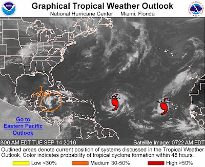
Current Atlantic Tropical Weather Outlook

Atlantic Graphical Tropical Weather Outlook

We are monitoring two active tropical storms at the moment:

Hurricane Igor & Hurricane Julia 

Click the following links for latest updates on these hurricanes 


Not the storm you are looking for?  Click Image or Here

Tropical Storm Julia Forms in Atlantic

Igor Expected to Become a Hurricane 

UPDATE:   This storm did strengthen into named Tropical Storm Karl and later Hurricane Karl

Tropical Storm Karl Heading Toward Yucatan

Meanwhile ... there appears to be another potential storm forming in the Northwest Caribbean Sea.  This is shown in the graphic from the NHC above as #1.   There is a medium chance that this depression will form into a tropical cyclone in the near future.


While there are no land advisories for the two hurricanes at the present time, this yet unnamed storm has the potential of producing heavy rains in the Caribbean.   No cruise ship advisories have been released at this time, but this latest storm has the potential of altering schedules should it intensify.


800 AM EDT TUE SEP 14 2010

FOR THE NORTH ATLANTIC...CARIBBEAN SEA AND THE GULF OF MEXICO...


THERE IS A MEDIUM CHANCE...40 PERCENT...
OF THIS SYSTEM BECOMING A TROPICAL
CYCLONE DURING THE NEXT 48 HOURS. 
 
REGARDLESS OF DEVELOPMENT... 
 
LOCALLY HEAVY RAINFALL IS POSSIBLE OVER PORTIONS OF JAMAICA...
CUBA...THE CAYMAN ISLANDS...AND THE YUCATAN PENINSULA DURING THE
NEXT DAY OR TWO.  THESE RAINS COULD CAUSE LIFE-THREATENING FLASH
FLOODS AND MUD SLIDES...ESPECIALLY IN AREAS OF MOUNTAINOUS TERRAIN. 


We will continue our coverage of tropical weather throughout the hurricane season.  

Queen Victoria Journeys to Paradise

Queen Victoria Royal Spa - Courtesy Cunard Line

Cunard’s Queen Victoria Bids “Aloha” to Hawaiian Voyages in 2011 

American Entertainment News Pioneer Rona Barrett Joins 17 February Voyage
to Raise Awareness for the Needs of Seniors

Riding the Surf on the Big Island, Hawaii


What is your Idea of Paradise?

In late January 2011, as part of Queen Victoria’s debut Americas Season, Cunard Line will offer guests the opportunity to experience The New Golden Age of Ocean Travel with luxury cruise vacations to the tranquil islands of Hawaii. 

Additionally, guests sailing on the 17 February voyage will enjoy a very special Cunard Insights programme presented by Rona Barrett, recognized as the “first lady of entertainment news.”

The Hawaiian Adventure cruises depart round-trip from Los Angeles for two relaxing weeks sailing the Hawaiian Islands; starting 30 January and again on 17 February, guests aboard Queen Victoria will visit Hilo (Hawaii), Honolulu (Oahu), Nawiliwili (Kauai) and Lahaina (Maui), as well as a quick visit to Ensenada (Mexico).

“Enjoying the tropical paradise of the Hawaii Islands is one of the many ways guests can create memorable experiences aboard Queen Victoria,” said Peter Shanks, president of Cunard Line. “We look forward to welcoming Rona Barrett as part of our Cunard Insights enrichment programme and know our guests are eager to hear her up close and personal stories about some of Hollywood’s most intriguing celebrities.”

Barrett is one of the pioneers and innovators in entertainment news reporting and publishing in the United States. She developed the first in-depth personal TV specials about the celebrities of film, television, music, sports and politics, and published a series of magazines on the entertainment industry for consumers and for industry insiders, including Rona Barrett’s Hollywood. She was also one of the original reporters for “Good Morning America” on ABC. Barrett recently returned to the spotlight, now appearing in a one-woman show, “Rona Barrett: Nothing But the Truth,” which premiered at The Paley Center for Media in Beverly Hills in June. Elements of this stage show will be performed for guests on board Queen Victoria as part of her enrichment programme. Barrett created the show to tour and raise funds in support of The Rona Barrett Foundation on behalf of senior citizens in need.

Proceeds from Barrett’s show appearances will support her foundation’s project of building The Golden Inn and Cottages, a pilot facility that can be constructed in communities throughout the U.S. to provide affordable housing and care, among many other elderly needs.

Delving deeply into a variety of compelling and relevant topics, Cunard Insights introduces guests to stimulating experts and accomplished visionaries who reflect the Line's heritage of adventure and prestige. Through a series of lectures, Q&A's, social gatherings and workshops, guests connect with personalities who have achieved notable distinction in areas including history, world affairs, science, arts and literature. The award-winning Insights programme underscores Cunard’s longstanding view that on board entertainment should afford guests a provocative and rewarding cerebral experience.

Barrett joins Cunard's illustrious legacy of welcoming world-famous guests, experts and intriguing presenters including Winston Churchill, President Nelson Mandela, Jean Chatzky, Tina Brown & Sir Harold Evans, Lady Margaret Thatcher, Elizabeth Taylor, James Taylor, Carly Simon, Rod Stewart, Archbishop Desmond Tutu and Buzz Aldrin.

Queen Victoria will spend more time on the west coast in winter 2011 as she comes off Cunard’s historic Royal Rendezvous in New York – where all three Queens will be docked on 13 January. Continuing to sail her Americas voyages, she will make three visits to the Panama Canal – including two transits, multiple visits to the port of Los Angeles, and her first short Getaway voyage to Mexico.