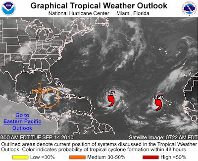
Atlantic Graphical Tropical Weather Outlook
We are monitoring two active tropical storms at the moment:
Hurricane Igor & Hurricane Julia
Click the following links for latest updates on these hurricanes
 |
| Not the storm you are looking for? Click Image or Here |
Tropical Storm Julia Forms in Atlantic
Igor Expected to Become a Hurricane
UPDATE: This storm did strengthen into named Tropical Storm Karl and later Hurricane KarlTropical Storm Karl Heading Toward Yucatan
Meanwhile ... there appears to be another potential storm forming in the Northwest Caribbean Sea. This is shown in the graphic from the NHC above as #1. There is a medium chance that this depression will form into a tropical cyclone in the near future.While there are no land advisories for the two hurricanes at the present time, this yet unnamed storm has the potential of producing heavy rains in the Caribbean. No cruise ship advisories have been released at this time, but this latest storm has the potential of altering schedules should it intensify.
800 AM EDT TUE SEP 14 2010

FOR THE NORTH ATLANTIC...CARIBBEAN SEA AND THE GULF OF MEXICO...
THERE IS A MEDIUM CHANCE...40 PERCENT...
OF THIS SYSTEM BECOMING A TROPICAL
CYCLONE DURING THE NEXT 48 HOURS.
REGARDLESS OF DEVELOPMENT...
LOCALLY HEAVY RAINFALL IS POSSIBLE OVER PORTIONS OF JAMAICA...
CUBA...THE CAYMAN ISLANDS...AND THE YUCATAN PENINSULA DURING THE
NEXT DAY OR TWO.  THESE RAINS COULD CAUSE LIFE-THREATENING FLASH
FLOODS AND MUD SLIDES...ESPECIALLY IN AREAS OF MOUNTAINOUS TERRAIN.
We will continue our coverage of tropical weather throughout the hurricane season.

No comments:
Post a Comment