Sunday, August 21, 2011

Pink Buses Back on Streets

Bermuda Bus Strike
Sent to Arbitration

A familiar site disappeared from the streets of Kings Wharf, Hamilton, and other parts of Bermuda on Wednesday.  Missing were the pink buses that normally shuttle locals and tourists around the island country.

Bus drivers called a strike Wednesday when a female driver was terminated for failing to take a mandatory drug screening following an accident.  She refused to take the test five times since the June accident.  Bermuda government policy requires drug testing following an accident and is a condition of continued employment.
Click here to learn more about Cruising to Bermuda
According to Bernews.com citizens were against the strike and were urging the driver to take the drug test. The buses are an integral part of the transportation system which also includes taxis and a ferry system. Officials were concerned about the safety of island inhabitants and tourists as they became stranded by the strike.

This is a busy time in the island country as cruise ships bring many passengers to the island country. The ships dock primarily at Kings Wharf or Hamilton, which then becomes the base of operations for touring.   The pink sand beaches and other nearby attractions are the perfect summer get-away destination.

Late Friday, the drivers agreed to bring their grievances before an arbitration board and also agreed to resume bus service on Saturday.  We are certain that citizens and tourists were happy to see the familiar pink buses back on the roads again.


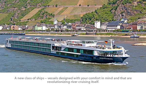
Avalon Panorama Mid-Cruise Repairs

Newest Avalon 
River Cruise Ship
Panorama
Unexpected Dry Dock

A brand new kind of ship, the Avalon Panorama set sail in 2011, taking inspired design to a whole new level. A unique 'Suite Ship', the Avalon Panorama was the first of its kind in the industry - with two full decks of suites featuring a Wall-to-Wall Panoramic Window that transforms the living space into a unique Open-Air Balcony.

    Built: 2011        Length: 443 ft.        Crew Members: 47        Staterooms: 17        Suites: 66

Propeller Repairs Needed

Avalon Panorama was unable to cruise at maximum speed due to a propeller problem that developed last Wednesday evening.  The cruise continued as planned, albeit at a slower speed, until Friday when passenger accommodations were made in Vienna hotels.   The cruise itinerary  then continued via bus while the ship underwent the propeller repairs in a dry dock facility in Linz.

The passengers and ship were scheduled to be reunited this morning in Krems where the cruise would continue as planned.   The next scheduled departure for Avalon Panorama is August 24th for a 14-Night Magnificent Europe, Budapest to Amsterdam cruise.


Had this same situation occurred on a large cruise ship, it may have meant the termination of the cruise.  The logistics to accommodate 166 passengers is much easier than for more than 1,000 passengers on the larger vessels.  We applaud Avalon Waterways for making every effort to continue the cruise.


If you aren't familiar with river cruising, we invite you to view our special page about the differences.   Warning - once you try river cruising, you might have a hard time returning to larger ships.


Saturday, August 20, 2011

Cruise Lines Return to Japan

 Costa Cruises to Homeport in Shanghai
Adds Sailings to Japan & South Korea

In March, 2011, Japan had a devastating earthquake and Severe Tsunami Impacting Japan & Hawaii. The world watched the unfolding nightmare as the country's nuclear plants were on the verge of meltdown. After the Tohoku Earthquake the cruise lines cancelled calls to ports in Japan.

Six Months Later...

The following announcement brings hope that life can be returning to normal in Japan. From August to October Costa Classica will home port in Shanghai, operating 12 cruises to Japan and South Korea. The selection of itineraries includes four-night cruises to Fukuoka, Japan, and Cheju, South Korea; a six-night cruise to Pusan, South Korea, and Fukuoka and Kagoshima, Japan; and a five-night cruise to Fukuoka and Nagasaki, Japan, and Cheju.

Costa Expansion in 2012

Next year Costa will substantially expand operations in Asia with the inaugural deployment of the 75,200-ton, 2,394-guest Costa Victoria, which will replace the 53,000-ton, 1,680-guest Costa Classica. The larger ship will offer 246 veranda cabins and increase Costa’s capacity in the region by 40 percent.

In 2012 Costa Victoria will call at new Japan destinations, including tropical Hososhima/Miyazaki; Wakayama, which boasts the country’s largest hot spring resort; Osaka, Japan’s second-largest city; the popular sightseeing cities in the Kanto Area; Yokohama and Tokyo, the nation’s capital.

Royal Caribbean International Also Returns

Starting in August and continuing to October, Legend of the Seas will be operating 11 sailings including a number of charters to various Japanese ports-of-call such as Okinawa, Fukuoka, Kagoshima, Beppu, Nagasaki and Hokkaido, out from Hong Kong, Tianjin and Shanghai.  These sailings are mostly based on the ship’s itineraries originally planned for this year, which do not call at the areas affected by the tsunami and nuclear crisis.


Kelvin Tan, Regional Director, Asia Pacific of Royal Caribbean Cruises Ltd. said, “Judging from the current situation in Japan, we are well-assured of the safety of traveling to Japan. Japan has always been an attractive tourist destination and its show of great resilience in the face of the recent crisis has given travelers the confidence to visit the country again.”

Other Cruise Lines

Holland America has not revised its schedule.  The line had canceled cruises through 2011 and modified others in 2012.

As we hear of any additional changes for the region, we will let you know.   For now it is good to see that the rebuilding continues as tourism returns to the country of Japan.


Related Blog Posts: 

Cruise Lines Return to Japan  (six months later, some cruise lines have returned)
 

Friday, August 19, 2011

Tropical Storm Forming Near Honduras

Tropical Depression 8 (TS Harvey)
Forms near Honduras
Tropical Storm Watches Posted 
1000 AM CDT SUN AUG 22 2011

...HARVEY DISSIPATES OVER THE SIERRA MADRE OF MEXICO...

We are monitoring a new storm which has formed off the Northeastern coast of Honduras in the Western Caribbean Sea. Tropical Depression Eight is forecast to become Tropical Storm Harvey on Saturday and weaken by Monday after making landfall.
 
Not the storm you are looking for?  Click Image or Here
Real-Time Cruise Ship Tracking
 There are no Cruise Ship Changes at this Time
SUMMARY OF 1000 AM CDT...1500 UTC...INFORMATION
-----------------------------------------------
LOCATION...18.1N 97.3W
ABOUT 105 MI...170 KM SW OF VERACRUZ MEXICO
MAXIMUM SUSTAINED WINDS...30 MPH...45 KM/H
PRESENT MOVEMENT...W OR 260 DEGREES AT 13 MPH...20 KM/H
MINIMUM CENTRAL PRESSURE...1008 MB...29.77 INCHES
 
THERE ARE NO COASTAL WATCHES OR WARNINGS IN EFFECT.
A TROPICAL STORM WARNING MEANS THAT TROPICAL STORM CONDITIONS ARE
EXPECTED SOMEWHERE WITHIN THE WARNING AREA WITHIN 36 HOURS. 
 
A TROPICAL STORM WATCH MEANS THAT TROPICAL STORM CONDITIONS ARE
POSSIBLE WITHIN THE WATCH AREA...IN THIS CASE AT ANY TIME WITHIN THE
NEXT 48 HOURS. 
MAXIMUM SUSTAINED WINDS HAVE DECREASED TO NEAR 25 MPH...45
KM/H...WITH HIGHER GUSTS.  WINDS WILL GRADUALLY DIMINISH AS THE
SYSTEM WEAKENS FURTHER TODAY.

HAZARDS AFFECTING LAND
RAINFALL...THE REMNANTS OF HARVEY ARE EXPECTED TO PRODUCE ADDITIONAL
RAINFALL ACCUMULATIONS OF 2 TO 4 INCHES OVER PORTIONS OF THE
MEXICAN STATES OF VERACRUZ...OAXACA...HIDALGO...PUEBLA...AND
TIAXCALA...WITH ISOLATED MAXIMUM STORM TOTAL AMOUNTS OF 6 INCHES. 
THESE RAINS COULD PRODUCE LIFE-THREATENING FLASH FLOODS AND MUD
SLIDES...ESPECIALLY IN AREAS OF STEEP TERRAIN.
 

Historical Data:         Storm Archive            Graphics Archive                          


1100 PM EDT THU AUG 18 2011
...TROPICAL DEPRESSION FORMS IN THE WESTERN CARIBBEAN SEA...
 
200 PM EDT FRI AUG 19 2011
...TROPICAL DEPRESSION EIGHT BECOMES TROPICAL STORM
HARVEY...TROPICAL STORM WARNING ISSUED FOR BELIZE...
 
1000 AM CDT SUN AUG 22 2011
...HARVEY DISSIPATES OVER THE SIERRA MADRE OF MEXICO...
THIS IS THE LAST PUBLIC ADVISORY ISSUED BY THE NATIONAL HURRICANE
CENTER ON HARVEY

Tropical Storm Resources (click links below)
TROPICAL STORM HARVEYNational Hurricane Center
Atlantic Tropical Weather OutlookNational Weather Service
Atlantic Tropical Weather DiscussionHurricane Preparedness
Graphical Tropical Weather Outlook (ATL) Real-Time Hurricane Information
Active Storms  NOAA Satellites & Information
NASA: Latest Storm ImagesWMO Severe Weather Information Centre
Real-time Monitoring (Atlantic)The Saffir-Simpson Hurricane Wind Scale
Real-time Weather SitesReal-Time Cruise Ship Tracking
 

Thursday, August 18, 2011

Temple of Poseidon Overlooks Aegean Sea

Temple of Poseidon
High atop a cliff ...

Temple of Poseidon

Departing from Central Athens, we journeyed by motorcoach Along The Attica Coast to Cape Sounion at the southernmost tip of the Attica peninsula. Sit back and relax as we take you on a virtual tour.

According to legend, Cape Sounion is the spot where Aegeus, king of Athens, leapt to his death off the cliff, thus giving his name to the Aegean Sea.

The temple of Poseidon, god of the sea, was constructed circa 440 BC.  It stands over the ruins of another temple dating from the Archaic Period. Perched above the sea at a height of almost 60 m, the temple has served as a landmark for sailors from ancient times through the present.  If you are awake as the ship approaches Athens, this is the first sight you'll see.

Temple of Poseidon's Doric columns
Local marble was used for the Temple of Poseidon's Doric columns.  During your visit you will be able to see 15 of the original 34 which survive today.

Doric columns stood directly on the flat pavement (the stylobate) of a temple without a base; their vertical shafts were fluted with 20 parallel concave grooves; and they were topped by a smooth capital that flared from the column to meet a square abacus at the intersection with the horizontal beam (entablature) that they carried.

The columns of the Temple of Poseidon were cut with only 16 flutings instead of the usual 20, which reduced the surface area exposed to the wind and sea water.

farewell Athens
The setting is known to have inspired poet Lord Byron and if you look carefully at the columns, you will find his name chiseled into the marble, dating back to his first visit to Greece.  We weren't inspired to write any poems, but we were inspired to take photos, which can be seen in our album, Temple of Poseidon.

Returning to Star Princess, following our exploration of Cape Sounion, we ended our visit to Athens. Our next port of call was Katakolon (Olympia), Greece. Visit our blog post, Diary of Cruise with Chris to Greek Isles, for the entire virtual tour. There you will find links to our other blog posts as well as links to the photos.


Med & Greek Isles Cruise Diary

Additional photos can be found on our Facebook Albums.


Click on the image to the left for more Blog posts about this trip.


@ChrisPappinMCC


Connect With Us On


Sign-up for Exclusive Email Offers


Where have you explored? 

Gather your travel and food pics and join us every Wednesday night for the latest installment of #FoodTravelChat

Wednesday, August 17, 2011

Along The Attica Coast

Scenic Athens Scenic Athens 

The Acropolis, Plaka & Temple of Poseidon shore excursion provides a glimpse at the many facets of Athens, Greece. 

The Acropolis and Temple of Poseidon are the bookends with ancient columns standing tall having withstood the test of time.  Plaka and Central Athens show the modern cosmopolitan Greece.  While the Attica Coast exposes the great beauty of the sea and the surrounding countryside.

Leaving Central Athens, we embarked on the scenic one-hour drive down Attica's rugged western coast, taking in views of rocky coves and the deep-blue Saronic Gulf as we made our way to Cape Sounion.  Our driver skillfully navigated the winding coastal road where every turn revealed another view of the coast with its main shades of blue waters and rocky cliffs.  

Since we had a schedule to maintain, we made no stops along the way, but our driver did slow down from time to time to allow us to take photos from the motorcoach.   It became a challenge to try to capture the coast line in all its glory as we headed to our final attraction for the day.

A picture is worth a thousand words, as the saying goes, so view our Scenic Attica Coast photo album on our Facebook Fan Page.   We invite you to sign up so that you'll receive updates when new material is posted.


Med & Greek Isles Cruise Diary

Additional photos can be found on our Facebook Albums.


Click on the image to the left for more Blog posts about this trip.


@ChrisPappinMCC


Connect With Us On


Sign-up for Exclusive Email Offers


Where have you explored? 

Gather your travel and food pics and join us every Wednesday night for the latest installment of #FoodTravelChat

Tuesday, August 16, 2011

Seventh Tropical Storm Forms in East Pacific

Tropical Depression Seven-E
Becomes TS Greg 
Now a Category One Hurricane
OFF THE COAST OF SOUTHERN MEXICO
 
200 PM PDT THU AUG 18 2011

...CENTER OF GREG PASSING BETWEEN SOCORRO ISLAND AND CLARION
ISLAND...
NHC ACTIVE STORMS (CLICK HERE)

We are monitoring a new storm which has formed off the coast of Southern Mexico. Tropical Depression Seven-E is forecast to become Tropical Storm Greg Tuesday night and a hurricane by Thursday.    
 
East Pacific Graphical Tropical Weather Outlook

Not the storm you are looking for?  Click Image or Here
 
SUMMARY OF 200 PM PDT...2100 UTC...INFORMATION
----------------------------------------------
LOCATION...18.8N 112.6W
ABOUT 335 MI...535 KM SSW OF THE SOUTHERN TIP OF BAJA CALIFORNIA
MAXIMUM SUSTAINED WINDS...85 MPH...140 KM/H
PRESENT MOVEMENT...WNW OR 285 DEGREES AT 14 MPH...22 KM/H
MINIMUM CENTRAL PRESSURE...980 MB...28.94 INCHES
THERE ARE NO COASTAL WATCHES OR WARNINGS IN EFFECT.
MAXIMUM SUSTAINED WINDS ARE NEAR 85 MPH...140 KM/H...WITH HIGHER
GUSTS.  GREG IS A CATEGORY ONE HURRICANE ON THE SAFFIR-SIMPSON
HURRICANE WIND SCALE.  THE CENTER OF GREG IS MOVING OVER COOLER
WATERS AND WEAKENING IS FORECAST DURING THE NEXT COUPLE OF DAYS.
 
HAZARDS AFFECTING LAND
----------------------
None
 
Historical Data:             Archive        Graphics Archive         

200 PM PDT TUE AUG 16 2011
...NEW TROPICAL DEPRESSION FORMS OFF THE COAST OF SOUTHERN MEXICO...

200 AM PDT WED AUG 17 2011
...DEPRESSION BECOMES TROPICAL STORM GREG...
 
800 PM PDT WED AUG 17 2011
...GREG BECOMES A HURRICANE AS IT MOVES FARTHER AWAY FROM
SOUTHWEST MEXICO...

Tropical Storm Resources (click links below)
Hurricane Greg
East Pacific Tropical Weather Outlook National Weather Service
East Pacific Tropical Weather Discussion Hurricane Preparedness
Graphical Tropical Weather Outlook (EPAC) Real-Time Hurricane Information
Active Storms  NOAA Satellites & Information
NASA: Latest Storm Images WMO Severe Weather Information Centre
Real-time Monitoring (E. Pacific) The Saffir-Simpson Hurricane Wind Scale
Real-time Weather Sites Real-Time Cruise Ship Tracking