Showing posts with label major hurricane. Show all posts

Tuesday, September 5, 2017

Hurricane Irma Cruise Ship Impact

Hurricane Irma Courtesy NOAA NHC 
MORE INFORMATION ABOUT HURRICANES (CLICK HERE)

HURRICANE IRMA
Impacting Cruises


Royal Caribbean Itinerary Updates 
September 13, 2017 at 6 PM EDT (next update 9/14 at 6 PM EDT)

NEW: Enchantment of the Seas: September 11 Bahamas cruise

We are canceling the Enchantment of the Seas cruise due to the continued closure of the port, and the uncertainty as to when normal operations will resume. We are very sorry for this impact to your vacation.

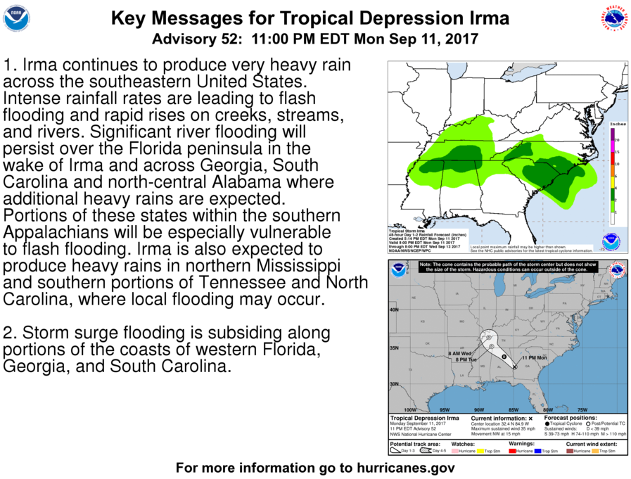
Irma is now a tropical storm with sustained winds of 70 mph. It is currently located just west of Gainesville on the Gulf Coast, moving north/northwest at 18 mph. The storm should exit the Florida area late Monday, pre-dawn Tuesday.

We are mobilizing ships and supplies to help people in need. In coordination with the US and local governments we are dispatching ships to St. Thomas and St. Maarten and stand ready to assist Key West, and other locations. Adventure of the Seas made a humanitarian stop in St. Maarten on Sunday and Majesty of the Seas will make humanitarian calls in St. Thomas and St. Maarten to provide supplies and also assist in transporting evacuees in St. Maarten to safety. Additionally, we have Empress of the Seas ready to assist Key West once the impact of the storm is known.
Read more ... Royal Caribbean IRMA Humanitarian Deployments

Florida airports are slowly getting up and running. For the most up-to-date information please visit the FAA website at www.fly.faa.gov.

For more frequent updates, please follow our meteorologist on Twitter @JamesVanFleet or visit the Royal Caribbean Facebook page.

SHIP
SAIL DATE
STATUS
DESTINATION
Allure of the Seas September 3 Modified Western Caribbean
Adventure of the Seas September 9 Modified Southern Caribbean
St. Maarten
Humanitarian Stop
Grandeur of the Seas September 7 As Scheduled New England/Canada
Liberty of the Seas September 10 As Scheduled Western Caribbean
Serenade of the Seas September 10 As Scheduled New England/Canada
Vision of the Seas September 7 As Scheduled New England/Canada
Enchantment of the Seas September 8 Cancelled Bahamas
Majesty of the Seas September 8 Cancelled Bahamas
Allure of the Seas September 10
September 13
Rescheduled Western Caribbean
4nt Bahamas
Anthem of the Seas September 9 Confirmed Bermuda
Empress of the Seas September 9 Cancelled Cuba
Harmony of the Seas September 9
September 12
Rescheduled Eastern Caribbean
4 nt Cozumel
Oasis of the Seas September 10
September 13
Rescheduled Eastern Caribbean
4 nt Cozumel
Enchantment of the Seas September 11
September 12
Cancelled Bahamas
Humanitarian Stop 
Majesty of the Seas September 11 Cancelled Bahamas (charter)
St. Thomas & St. Maarten
Humanitarian Stops
Empress of the Seas September 13 Cancelled Cuba
St. Thomas & St. Maarten
Humanitarian Stops
Majesty of the Seas September 15 Cancelled Bahamas 
Ready to assist Key West
Humanitarian Stops

Norwegian Cruise Line Weather Alert 

September 12th 1:00 PM ET (5:00 PM UTC)

Further to our update from Friday afternoon, Norwegian Escape and Norwegian Sky have both safely departed from PortMiami. Norwegian Escape is sailing at full capacity with approximately 4,000 displaced guests from both ships that were unable to secure flights back home. The ship is remaining alongside in Cozumel, Mexico Sunday until 5 pm and then will go to sea. Once the storm has safely passed and PortMiami reopens, the ship will proceed towards Miami. Due to the devastating impact in the Caribbean from Hurricane Irma, all of Norwegian Escape’s upcoming Eastern Caribbean sailings until November will be altered to a Western Caribbean itinerary.

Norwegian Sky is now on a rescue mission (see the following article).  Norwegian Sky on IRMA Rescue Mission

As per the State Department, affected US Citizens on St. Thomas should email name, gender, & last known location to IrmaEmergencyUSC@state.gov.

As the safety and security of our team members is our top priority, Norwegian Cruise Line's Miami headquarters will remain closed through Tuesday, September 12 and are scheduled to re-open on Wednesday, September 13. To ensure that we continue to operate with all the necessary shoreside support, key staff members have been relocated out of Miami and the storm zone.

SHIP
SAIL DATE
STATUS
DESTINATION
Norwegian Escape September 2 Shortened Western Caribbean
Norwegian Escape September 7 Modified Away from Storm
Departing Cozumel
For Miami 9/11 (5 PM)
Norwegian Escape September 9 Cancelled Eastern Caribbean
Norwegian Sky September 4 Shortened Cuba
Norwegian Sky September 8 Cancelled Bahamas
Away from Storm
Norwegian SkySeptember 11CancelledBahamas
Rescue - USVI
Norwegian SkySeptember 15As ScheduledWestern Caribbean
Norwegian EscapeSeptember 16As ScheduledWestern Caribbean

Disney Cruise Line Weather Alert 

Tropical Weather Update September 14, 2017 – 9:00 a.m. 


Disney Fantasy - September 23 and October 7 Sailings 

The September 23 and October 7 Disney Fantasy Eastern Caribbean sailings are being modified to include ports of call in the Western Caribbean. These two revised sailings will now visit Cozumel, Mexico; George Town, Grand Cayman; and Falmouth, Jamaica.

Please know that further changes may be needed as the Caribbean islands continue to recover from the impacts of Hurricane Irma and that we will notify Guests should additional changes be necessary. Western Caribbean sailings will continue as scheduled.

Should you have any questions related to a future reservation, please call us at 1-855-347-2784 or 407-566-7054.

SHIP
SAIL DATE
STATUS
DESTINATION
Disney Fantasy September 2 Shortened Western Caribbean
Disney Fantasy September 9 Cancelled Eastern Caribbean
Disney Dream September 4 Modified Bahamas
Disney Dream September 8 Cancelled Bahamas
Disney Dream September 11 Cancelled Bahamas
Disney Dream September 15 As Scheduled Bahamas
Disney Fantasy September 16 As Scheduled Western Caribbean
Disney Fantasy September 23 Modified Eastern Caribbean
Western Caribbean
Disney Fantasy October 7 Modified Eastern Caribbean
Western Caribbean


Carnival Cruise Line Travel Alerts
Weather update 9/13/2017 – 8:30 PM (EDT)


As a result of damage caused by Hurricane Irma, we have modified the following (September 16-18) itineraries in order to provide our guests with the best possible shore experience.


SHIP
SAIL DATE
STATUS
DESTINATION
Carnival Glory September 2 Modified Eastern Caribbean
Carnival Magic September 3 Modified Eastern Caribbean
Carnival Splendor September 3 Modified Eastern Caribbean
Carnival Pride September 3 Modified Eastern Caribbean
Carnival Liberty September 7 Cancelled Bahamas
Carnival Paradise September 7 As Scheduled Cuba & Cozumel
Carnival Sensation September 7 As Scheduled Western Caribbean
Carnival Victory September 8 Cancelled Bahamas
Carnival Conquest September 9
September 12
Rescheduled 3 NT Cozumel
Carnival Glory September 9
September 12
Rescheduled 3 NT Cozumel
Carnival Magic September 9
September 13
Rescheduled Western Caribbean
2 NT Bahamas
Carnival Splendor September 9 Cancelled Eastern Caribbean
Carnival Vista September 9
September 12
Rescheduled Eastern Caribbean
4 NT Western
Carnival Freedom September 9 Modified Eastern Caribbean
Western Caribbean
Carnival Ecstasy September 9 Cancelled Bahamas
Carnival Liberty September 10 Cancelled Bahamas
Carnival Fascination September 10 Monitoring Southern Caribbean
Carnival Pride September 10 Modified Eastern Caribbean
Canada
Carnival Dream September 10 Modified Eastern Caribbean
Western Caribbean
Carnival Sensation September 11
September 13
Rescheduled Western Caribbean
2 NT Bahamas
Carnival Victory September 11
September 12
Rescheduled Bahamas
Carnival Paradise September 11 As Scheduled Western Caribbean
Carnival Glory September 16 Modified Miami 7 day
Half Moon Cay, San Juan, Grand Turk
Carnival Paradise September 16 Modified Tampa 5 day
Grand Cayman, Cosumel
Carnival Magic September 16 Modified Port Canaveral 8 day
Grand Turk, San Juan, St. Kitts, Antigua
Carnival Breeze September 17 Modified Galveston 7 day
Freeport and Nassau
Carnival Fascination September 17 Modified San Juan 7 day
Dominica, Barbados, St. Lucia, Antigua, St. Kitts
Carnival Victory September 18 Modified Miami 4 day
Cozumel


MSC Cruises Itinerary Updates

Weather advisories & Itinerary updates (updated September 13, 10:30am)

MSC Divina – update regarding the current cruise as well as future itineraries 

On the current cruise 

MSC Divina has now returned to the Port of Miami. She is already at berth and has received authorization from local authorities to carry out disembarkation procedures from 12 to 5pm EST today.

On future itineraries 

On Saturday, September 16, MSC Divina will operate a West Caribbean cruise out of Miami, calling at Montego Bay (Jamaica), Georgetown (Cayman Islands), Costa Maya (Mexico) and Nassau (Bahamas).

From Saturday, September 23, MSC Divina will resume her scheduled service, alternating East and West Caribbean cruises on a weekly basis. For East Caribbean cruises, Antigua will replace the scheduled call at Philipsburg (St. Maarten), until the island recovers from Hurricane Irma’s passage.

MSC Opera – update on future itineraries 

Following the passage of Hurricane Irma through the Caribbean and in connection with the reopening of both the port and airport in Havana, MSC Opera will now resume operating regular cruise service out of Havana, Cuba from 16 September onwards – with unchanged itineraries.

SHIP
SAIL DATE
STATUS
DESTINATION
MSC Divina September 2 Shortened Eastern Caribbean
MSC Divina September 9 Cancelled Eastern Caribbean
MSC Divina September 16 Modified Eastern Caribbean
Western Caribbean
MSC Divina September 23 Modified Eastern Caribbean
Western Caribbean
MSC Opera September 16
(onwards)
As Scheduled Havana, Cuba


Celebrity Cruises Travel Alert 

SHIP
SAIL DATE 
STATUS
DESTINATION
Celebrity EquinoxSeptember 4ModifiedSouthern Caribbean


Hurricane Preparedness Mini-Series:


Saturday, September 2, 2017

Watching Hurricane Irma

Hurricane Irma Courtesy NOAA NHC


Due to the volatility of the Cruise Ship Impact, we have switched to a tabular format which can be found by clicking on the image above.  We will continue to monitor the storm as long as it poses a threat to cruises / land.
MORE INFORMATION ABOUT HURRICANES (CLICK HERE)


Hurricane Preparedness Mini-Series:


We are in the peak of the 2017 Atlantic Hurricane Season and there is plenty of activity to keep an eye on. With Hurricane Harvey still causing heavy rainfall inland, new storms are developing off of Cabo Verde in the Atlantic. One storm has already become a Category 4 Hurricane and the other is forming right behind. There has already been impacts to scheduled cruises, and more disruption is anticipated.  The exact path of the hurricane isn't known due to changing conditions in the Atlantic.

4 Things To Help Plan Vacation in Hurricane Season
HURRICANE IRMA
Impacting Cruises

This storm is expected to change in strength and direction over the next few days.  Anyone living in the vicinity of the storms current path or traveling on a cruise in the Atlantic should keep an eye on the potential impact to your plans.

Now is the time to prepare - click on our preparedness links for assistance in planning.  Click the image below for the latest updates from NOAA NHC.


Hurricane Irma has already forced cancellations of upcoming cruises.  Monitor the cruise line's websites and social media for up to the minute updates.  We will attempt to update this page frequently as well.


HURRICANE IRMA 
800 PM AST Tue Sep 05 2017
...POTENTIALLY CATASTROPHIC CATEGORY 5 HURRICANE IRMA NEARING THE
NORTHERN LEEWARD ISLANDS...
...WEATHER CONDITIONS WILL DETERIORATE OVER THE NORTHERN LEEWARD
ISLANDS SOON...
WIND:
MAXIMUM SUSTAINED WINDS...185 MPH...295 KM/H
Currently Extremely Dangerous Category 5  
WATCHES/ WARNINGS:
SUMMARY OF WATCHES AND WARNINGS IN EFFECT:

A Hurricane Warning is in effect for...
* Antigua, Barbuda, Anguilla, Montserrat, St. Kitts, and Nevis
* Saba, St. Eustatius, and Sint Maarten
* Saint Martin and Saint Barthelemy
* British Virgin Islands
* U.S. Virgin Islands
* Puerto Rico, Vieques, and Culebra
* Dominican Republic from Cabo Engano to the northern border with
Haiti

A Hurricane Watch is in effect for...
* Guadeloupe
* Haiti from the northern border with the Dominican Republic to Le
Mole St. Nicholas
* Turks and Caicos Islands
* Southeastern Bahamas
* Cuba from Matanzas province eastward to Guantanamo province

A Tropical Storm Warning is in effect for...
* Guadeloupe
* Dominica
* Dominican Republic from south of Cabo Engano westward to the
southern border with Haiti

A Tropical Storm Watch is in effect for...
* Haiti from south of Le Mole St. Nicholas to Port-Au-Prince
SHIP IMPACT:
These cruise line links will be active when tracking storms:

Carnival Cruise Line 
Disney Cruise Line
Royal Caribbean
Norwegian Cruise Line
MSC Cruises

Several Itineraries have been modified / cancelled
   
Storm Archive       Graphics Archive


A Hurricane Warning means that hurricane conditions are expected
somewhere within the warning area.  A warning is typically issued
36 hours before the anticipated first occurrence of tropical-storm-
force winds, conditions that make outside preparations difficult or
dangerous.  Preparations to protect life and property should be
rushed to completion.

A Hurricane Watch means that hurricane conditions are possible
within the watch area.  A watch is typically issued 48 hours before
the anticipated first occurrence of tropical-storm-force winds,
conditions that make outside preparations difficult or dangerous.

A Tropical Storm Warning means that tropical storm conditions are
expected somewhere within the warning area within 36 hours.

A Tropical Storm Watch means that tropical storm conditions are
possible within the watch area, generally within 48 hours.

Interests elsewhere in the Dominican Republic, along with Haiti,
the Turks and Caicos Islands, Cuba, and the southeastern and central
Bahamas should monitor the progress of Irma.

Royal Caribbean Itinerary Updates  (click for latest update)

September 5, 2017 at 6:00 PM EDT (next update tomorrow at noon EDT)

We are closely monitoring Hurricane Irma’s path and its potential impact to our current and upcoming sailings. Royal Caribbean’s Chief Meteorologist, James Van Fleet, is closely tracking the storm’s progress, and the current forecast is as follows:

Hurricane Irma is a category 5 hurricane with sustained winds around the center at 185 mph and is currently located about 210 miles east of Antigua. The storm continues its westerly track at 15 mph. While it is difficult to predict the path of the storm at this time, it is likely that Irma will impact Florida at some point this weekend.

In an effort to give you advance notice of any changes while also taking into account the most accurate forecast information, we will be providing updates on any impacted sailings no later than 2 days in advance of departure.

The following sailings are departing as scheduled:

Adventure of the Seas: September 9 Southern Caribbean cruise
Grandeur of the Seas: September 7 New England/Canada cruise
Liberty of the Seas: September 10 Western Caribbean cruise
Serenade of the Seas: September 10 New England/Canada cruise
Vision of the Seas: September 7 New England/Canada cruise

The following sailings are canceled:

Enchantment of the Seas: September 8 Bahamas cruise
Majesty of the Seas: September 8 Bahamas cruise

We are very sorry for the impact this storm has had on your vacation and please know that we made the decision with the safety and comfort of our guests and crew in mind. The cruise fare and fees will be 100% refunded to the original form of payment, and we are also offering a 25% future cruise credit, based on the cruise fare, if a new cruise is booked in the next 30 days. If you have any questions, please don't hesitate to call 1-800-256-6649.

The following sailings are currently being evaluated and we will provide our next update at noon EDT tomorrow:

Allure of the Seas: September 10 Western Caribbean cruise
Anthem of the Seas: September 9 Bermuda cruise
Empress of the Seas: September 9 Cuba cruise
Harmony of the Seas: September 9 Eastern Caribbean cruise
Oasis of the Seas: September 10 Eastern Caribbean cruise

For all guests currently sailing with us, the Captain and team onboard will be providing you specific updates at 1 pm and 615 pm daily, and of course will update you immediately if anything changes.

Should we need to make additional itinerary changes or cancel an additional sailing to avoid the storm, we will reach out to guests directly, as well as update our website and social media feeds immediately. Please know that the safety and comfort of our guests are our top priority and we will continue to provide regular updates throughout the week.

For more frequent updates, please follow our meteorologist on Twitter @JamesVanFleet or visit the Royal Caribbean Facebook page.

Allure of the Seas (September 3 sailing) is currently sailing a modified Western Caribbean itinerary.


Norwegian Cruise Line Weather Alert (click for latest)

September 5th at 2:00 PM ET (6:00 PM UTC) 

 At Norwegian Cruise Line, the safety and security of our guests and crew is of the utmost importance. The company is closely monitoring Hurricane Irma, now a major category 5 hurricane, located just east of the Leeward Islands. The storm’s forecasted path includes a potential impact to South Florida this weekend.

 Due to the current forecasted path of the storm, we will be making adjustments to the following cruises to ensure the safety of everyone on board:

Norwegian Escape, Seven-Day Western Caribbean cruise departing September 2 from Miami:

We will be amending the ship’s itinerary to a five-day cruise. Instead of calling in Costa Maya on Wednesday and Cozumel on Thursday, the ship will sail for Miami this evening, arriving in the afternoon on Thursday, September 7. Those guests who are residents of South Florida, who drove to PortMiami or who have travel plans already confirmed that will return them safely home by Friday afternoon may disembark the ship on Thursday if they wish to do so. For those guests who did not drive to PortMiami and are unable to secure a flight back home, we strongly encourage them to stay onboard the ship.

Norwegian Escape will set sail from Miami on Thursday evening on a course away from the storm. While we are unable to confirm at this time when and where the ship will return to port, we welcome all guests to remain onboard to stay safe and secure.

All guests will received a refund for the missed days of their cruise, along with a 25% future cruise credit of the cruise fare paid towards a future sailing on Norwegian. Guests who need to make changes to any flights will be reimbursed for any change fees up to $300 per person.

Norwegian Sky, Four-Day Cuba Cruise departing September 4 from Miami:

We will be amending the ship’s itinerary to a three-day cruise. Instead of calling in Great Stirrup Cay on Thursday, the ship will sail for Miami following her departure from Havana tomorrow, arriving in the morning on Thursday, September 7.

All guests will receive a refund for the missed day of their cruise, along with a 25% future cruise credit of the cruise fare paid towards a future sailing on Norwegian. Guests who need to make changes to any flights will be reimbursed for any change fees up to $300 per person

Norwegian Sky, September 8 from Miami:

The ship’s three-day Bahamas cruise has been cancelled. We will be providing a full refund to all guests, plus a 50% future cruise credit.

Norwegian Escape, September 9 from Miami: The ship’s seven-day Eastern Caribbean Cruise has been cancelled.

We will be providing a full refund to all guests, plus a 50% future cruise credit. All other cruises are currently sailing as scheduled.

We continue to monitor the storm’s projected path and will provide any updates as quickly as they are available. We truly appreciate our guests understanding during these unforeseen itinerary changes and apologize for any inconvenience these unexpected, but necessary, changes may cause our guests. Any further updates will be communicated here and to guests and posted on our social media channels.


Disney Cruise Line Weather Alert (click for latest)

Tropical Weather Update September 5, 2017 – 7:30 p.m.

Based on the projected path of Hurricane Irma, including its expected impact on the Caribbean and Bahamas, Disney Cruise Line is making the following adjustments to itineraries:

Disney Fantasy The September 2 cruise of the Disney Fantasy is currently sailing a modified Western Caribbean itinerary and is expected to return to Port Canaveral two days earlier than planned on Thursday, September 7.

Guests on this sailing will be refunded two nights of their voyage fare and provided a 25 percent discount on a future cruise, which may be booked by calling 1-855-347-2784 or 407-566-7054 from September 18, 2017, through October 18, 2017.

The September 9 sailing of the Disney Fantasy is cancelled. 

Refunds will automatically be processed back to the original form of payment used for the cruise booking. Guests are invited to book a future cruise at a 25 percent discount by calling us at 1-855-347-2784 or 407-566-7054 from September 18, 2017, through October 18, 2017.

While we always strive to deliver magical cruise vacations, nothing is more important to us than providing a safe experience for our guests and crew. We will continue to closely monitor Hurricane Irma and provide updates as necessary.

Disney Dream The September 4 cruise of the Disney Dream is sailing a modified Bahamian cruise itinerary and will return to Port Canaveral one day earlier than planned on Thursday, September 7.

Guests on this sailing will be refunded one night of their voyage fare and provided a 25 percent discount on a future cruise, which may be booked by calling 1-855-347-2784 or 407-566-7054 from September 18, 2017, through October 18, 2017.

The September 8 and September 11 sailings of the Disney Dream are cancelled.

Refunds will automatically be processed back to the original form of payment used for the cruise booking. Guests are invited to book a future cruise at a 25 percent discount by calling us at 1-855-347-2784 or 407-566-7054 from September 18, 2017, through October 18, 2017.

While we always strive to deliver magical cruise vacations, nothing is more important to us than providing a safe experience for our guests and crew. We will continue to closely monitor Hurricane Irma and provide updates as necessary.

Friday, August 26, 2011

Bracing for Major Hurricane Irene

High above the Earth from aboard the International Space Station,
astronaut Ron Garan snapped this image of Hurricane Irene
as it passed over the Caribbean on Aug. 22, 2011.                  Credit: NASA
Major Hurricane Irene
Continues to Impact
Cruise Schedules


East Coast Bracing 
for Landfall

For the second weekend in a row, Irene, now a Major Hurricane, is dominating the weather and causing local governments and the entire travel industry to scramble to revise schedules to keep property and people safe from harm.
200 PM EDT SUN AUG 28 2011

...CENTER OF IRENE MOVING OVER SOUTHERN NEW ENGLAND...
Warnings Issued for Hurricane Irene -- See this post for current warnings, location, hazards, and other updates

      CURRENT WARNINGS       TRAVEL ADVISORIES        StormScape LIVE    
 
Despite Hurricane Irene's weakening to a Category One status, it is still packing quite a punch and has local governments scrambling to keep property and residents safe.   The NHC is warning that all of the tropical cyclone Hazards:  Wind, heavy Rainfall, Storm Surge, Surf, and Tornadoes are forecast.

Hurricane of the Century


The GOES-13 satellite saw Hurricane Irene
on August 27, 2011 at 10:10 a.m. EDT
after it made landfall at 8 a.m. in Cape Lookout, NC.
Irene's outer bands had already extended into New England.
(Credit: NASA/NOAA GOES Project)

Click image for more dramatic images of Hurricane Irene
Many are referring to Hurricane Irene as the storm of the century.   Mandatory evacuations have begun for parts of the eastern seaboard of the United States.  The picture above, courtesy of NASA, shows why there is this great concern.   The hurricane is massive!  As we write this article, Irene is a Category Three Hurricane with winds in excess of 115 MPH.   Hurricane force winds extend outward up to 80 miles from the center and tropical storm force winds extend outward up to 290 miles.

Ten States Declare Emergencies - Mandatory Evacuations Across the Region
Transportation Systems Shut Down

Irene will move northwest and approach the North Carolina Coast this weekend before continuing its journey north, skimming the Mid-Atlantic coast with possible landfall in New England.

Fifty-five million people are potentially in Hurricane Irene's path, from the Carolinas to Cape Cod on the U.S. East Coast, and tens of thousands are evacuating as cities including New York brace for the powerful storm to hit.

NYC Unprecedented Evacuation / Transit Shutdown

As powerful Hurricane Irene makes it way up the East Coast of the United States, New York City ordered nearly 300,000 people to evacuate flood-prone areas and subways.  The New York's Metropolitan Transportation Authority (MTA) has begun a full system shutdown.  Philadelphia and New Jersey will also shut down on Saturday.

It was the first time the nation's largest city was evacuated. Never before has the entire mass transit system been shuttered because of a storm.  New York city has not seen a storm of this magnitude in decades.

Mayor Michael Bloomberg said he was confident people would get out of the storm's way.
"Waiting until the last minute is not a smart thing to do," Bloomberg said. "This is life-threatening."

President Obama spoke with reporters from the farm where he is vacationing on an island off the Boston coast.  He will be leaving the area on Saturday well ahead of the storm.

"All indications point to this being a historic hurricane," 
"I cannot stress this highly enough. If you are in the projected path of this hurricane, you have to take precautions now. Don't wait. Don't delay," Obama said.


Cruise Ship Travel Alerts

This past week, many cruises had their itineraries altered to outrun the storm.   In most cases, port orders were changed or in some cases, Bahamas ports were swapped for Western Caribbean ports.

As the weekend approaches and the hurricane bears down on many of the homeports along the east coast, ships are racing to arrive ahead of the storm.  Several itineraries have been modified to cut the current cruise short, arriving in the homeport as much as a day early.  Some ships will delay arrivals until Monday. Departures for weekend cruises vary by port with some scheduled on time while others departing a day or more late. 

Ports impacted:  Baltimore, Bayonne New Jersey, Boston, New York, 

Travel Advisory Links:


Airline Travel Advisories

Major airlines -- including US Airways, American, United Airlines, Continental Airlines, Delta, JetBlue, Southwest Airlines and AirTran -- have dropped ticket change fees for passengers scheduled to fly to or from many cities along the East Coast this weekend. 

Airlines canceled more than 9,000 flights for the weekend and another 250 on Monday, according to the online flight tracking service Flightaware.com.

Check directly with your airline carrier for latest cancellation information


Additional Travel Woes
Transit systems in New York City, Philadelphia and New Jersey   shut down on Saturday.

Greyhound has canceled or delayed a number of routes because of the storm.

Hurricane Preparedness

Each year NHC, FEMA, and other government agencies host several events to raise awareness about the dangers of tropical storms and hurricanes.  See our Hurricane Zone for links to articles we published in conjunction with this year's Hurricane Preparedness Week as well as those from past years.  For those planning to sail this weekend, be sure to read Hurricane Preparedness for Cruisers

We will continue to monitor this major hurricane and post updates.  Hurricane Zone will point to the latest information.   We have provided several links which provide up to the minute news, forecasts, advisories.

Disaster Prevention should include:


"How To" guides for protecting your property from flooding & high winds. (FEMA)

Wednesday, August 24, 2011

Warnings Issued for Hurricane Irene


Ninth Named Storm in Atlantic Basin

First Advisory Includes Tropical Storm Warnings


Irene Becomes 1st Hurricane
of 2011 Atlantic Season
Became a Major Hurricane 
Made Landfall on U.S. 
1100 PM EDT SUN AUG 28 2011
...IRENE BECOMES POST-TROPICAL NEAR THE U.S./CANADIAN BORDER... 

...MAJOR RIVER FLOODING OCCURRING IN PARTS OF THE NORTHEAST...

Tracking Storm since Saturday, August 20th 


The GOES-13 satellite saw
Hurricane Irene entering the Bahamas 

on August 24, 2011 at 1302 UTC (9:02 a.m. EDT).
Credit: NASA/NOAA GOES Project
Our coverage of Hurricane Irene began when it became a tropical storm Saturday, August 20th.  It formed East of the Lesser Antilles and took a path South of Puerto Rico continuing in a northwestward direction.  As predicted Irene strengthened into a hurricane before interacting with Hispaniola.  Due to the potential to interact with land, it was difficult to predict further strength and movements beyond the first few days.


Several hurricane and tropical storm watches and warnings were posted as the storm moved through the islands on its way towards the Bahamas. The Hurricane is expected to make landfall on the East Coast of the United States this weekend. It could become a Category Four hurricane before hitting land.  This was a very dangerous  Hurricane and evacuations were ordered all along the eastern seaboard of the United States.   Consult our Hurricane Preparedness links on Hurricane Zone if you are in the path of the hurricane.  Several cruise itineraries have been modified to stay clear of the storm.

August 28th 11 PM EDT - Irene loses tropical characteristics, but not until she was done ravaging the East Coast of the United States as well as several Caribbean ports of call.   Bahamas had extensive damage with many of the private islands, that cruise lines call on, needing to be repaired.   

Saturday and Sunday were very long days for residents in NC all the way up the East Coast.  The winds weren't the main problem, but rather the storm surge and inland flooding caused the most destruction.  The danger isn't over from the raging waters.   At first light on Monday, some areas will get their first look at just how bad things are (and it's not over).


GALE-FORCE WINDS ARE EXPECTED TO AFFECT COASTAL AREAS FROM EASTERN
LONG ISLAND TO MAINE THROUGH EARLY MONDAY.
THE CENTER OF IRENE WILL MOVE OVER EASTERN CANADA TONIGHT
AND ON MONDAY.
 
Not the storm you are looking for?  Click Image or Here
Real-Time Cruise Ship Tracking


Cruise Itinerary Changes

Several ships are in the vicinity of Irene and their itineraries were modified:


Latest Travel Advisories: (Updated 8 PM EDT Saturday, August 27).  
Links provided for changes between our updates.


CARNIVAL PRIDE – 8/28/11: Port Canaveral (Tuesday, instead of Wednesday) and Freeport (Wednesday), after which the line will determine the remainder of the itinerary based on Irene's projected path.  USCG has directed the Pride's captain to arrive early and proceed to a secure location to ride out the hurricane.  Embarkation for the 8/28 cruise is scheduled for Monday, August 29th from 10am to 2 PM at the Baltimore cruise terminal.  


The ship is now scheduled to call on..


Day     Port of Call                                                Arrive           Depart
Mon    Baltimore, MD                                        10:00 AM     2:00 PM
Tue     Fun Day @ Sea
Wed   Port Canaveral (Orlando), FL                   10:00 AM     7:00 PM
Thu    Nassau, The Bahamas 1                             1:00 AM   10:00 PM
Fri      Freeport, The Bahamas                             7:00 AM     2:00 PM
Sat     Fun Day @ Sea
Sun    Baltimore, MD                                          9:00 AM

Should any guests be delayed due to flight cancellations, if you purchased your air with Carnival, please contact us so we can make alternate arrangements for you. 

Guests who purchased independent air, are kindly requested to make independent arrangements to catch up with the ship at the first port of call.


Regrettably, the island of CocoCay, Bahamas, was impacted by the storm, and we feel our guest's experience ashore would be disrupted. Because of this, we have cancelled Majesty of the Seas'call to CocoCay for today, August 27, Monarch of the Seas' call to CocoCay on Sunday, August 28, and Freedom of the Seas' call to CocoCay on Monday, August 29.

Monarch of the Seas will now stay overnight in Nassau, Bahamas, departing at 11:00 a.m. today, August 28.

Freedom of the Seas
will call on Nassau, Bahamas, on Monday, August 29 from 8:00 a.m. to 4:00 p.m.

Majesty of the Seas will also stay overnight in Nassau, Bahamas, arriving at 12:00 p.m. today and departing at 5:00 pm. on Sunday, August 28.


Veendam - current sailing: Bermuda (depart 5 PM Thursday instead of Friday), Arrive New York Saturday (one day early).  Passengers can disembark on Saturday or overnight until Sunday.

Veendam 8/28 Sailing: The ship will remain in New York overnight on Sunday, August 28, and will now depart Monday, August 29, at 2:00 pm. Guests will be able to embark as scheduled on Sunday provided there is access to the cruise terminal. Due to the government declared evacuation of some areas of the city and impending transit challenges, access to the cruise terminal may be limited or closed on Sunday.
Embarkation on Monday, August 29 will begin at 8:00 am and continue until 1:00 pm, at which time all passengers should be on board the ship.

The revised itinerary is below:  ms Veendam August 28, 7-day Bermuda Cruise


DATE LOCATION ARRIVE DEPART
Sunday, Aug 28 New York
overnight
Monday, Aug 29 New York
2 pm
Tuesday, Aug 30 At Sea

Wednesday, Aug 31 Hamilton, Bermuda 9 am overnight
Thursday, Sept 1 Hamilton, Bermuda
overnight
Friday, Sept 2 Hamilton, Bermuda
2 pm
Saturday, Sept 3 At Sea

Sunday, Sept 4 New York 7am

For guests considering embarkation on Sunday, Holland America Line encourages guests to check local New York City transit and government websites (www.NYC.gov or www.mta.info). If you are in the local area, you can also call our special information line at 732-698-1222 for the latest information on access to the pier.


ms Maasdam August 27, 7-day Canada/New England Cruise (Boston to Montreal, Quebec)
Guests embarked in Boston on Saturday, August 27, as planned and the ship sailed at 5:00pm prior to the storms arrival. Due to very high winds and rough seas expected near the first two port calls of Bar Harbor, Maine, and Halifax, Nova Scotia, these calls have been cancelled and the itinerary modified, adding the ports of Gaspe and Saguenay, Quebec later in the week.


DATE LOCATION ARRIVE DEPART
Saturday, Aug 27 Boston
5:00 pm
Sunday, Aug 28 At Sea

Monday, Aug 29 Sydney, Nova Scotia 8:00 am 5:00 pm
Tuesday, Aug 30 Charlottetown, PEI 8:00 am 5:00 pm
Wednesday, Aug 31 Gaspe, Quebec 7:00 am 1:00 pm
Thursday, Sept 1 Saguenay, Quebec 12:00 noon 8:00 pm
Friday, Sept 2 Quebec 7:00 am 5:00 pm
Saturday, Sept 3 Montreal 7:00 am

Updates will also be posted at 10:00 am and 10:00 pm PDT


Summit: will remain in Bermuda until 5:00 p.m. today, Friday, August 26. We now anticipate that the ship will arrive in Bayonne, New Jersey, on Monday, August 29. 

Next sailing will now depart on Monday, August 29. Guests scheduled to sail on the Sunday, August 28, sailing of Celebrity Summit should now arrive at Cape Liberty on Monday between 12:00 p.m. and 4:00 p.m. 


Norwegian Jewel will return to New York early on Saturday, August 27 and guests currently on board will disembark beginning at 6 am. Embarkation for the August 27 cruise will commence earlier beginning at 10 am. The ship will depart three hours earlier than scheduled at 1 pm. All guests are advised to arrive at the pier between 10 am and noon. Once the ship is underway, there may be a change to the scheduled Bahamas & Florida itinerary.
Norwegian Gem will remain at sea, keeping a safe distance from the storm, on Sunday, August 28 instead of returning to New York as scheduled. The ship will arrive in New York at 8 am on Monday, August 29. All guests for the August 28 cruise are asked to arrive at the pier on Monday, August 29 beginning at noon. The ship is scheduled to depart New York at 4 pm on Monday en route to Bermuda.
Both Norwegian Dawn sailing from Boston and Norwegian Sky sailing from Miami today will depart as scheduled.


Caribbean Princess will arrive in New York on Saturday, August 27, one hour early at 6 a.m. In addition, check-in for the next cruise will begin at 10 a.m. instead of 1 p.m. in anticipation of an early departure.  Itinerary has been altered slightly; Monday, a sea day will replace a call at Halifax but the ship will visit there Tuesday. The planned Tuesday call at St. John is canceled. 


Disney Cruise Line


Disney Dream did not stop at the line's private island of Castaway Cay on Saturday, August 27, due to the storm's impact. Instead, the ship spent an additional day in Nassau.                                                    
See Historical Data below for changes earlier in the week

MONITOR LINKS FOR LAST MINUTE CHANGES FOR WEEKEND CRUISES
 
IRENE IS BEING CLOSELY MONITORED BY ALL CRUISE LINES AND ADDITIONAL CHANGES MAY BE NECESSARY.  GUESTS WILL BE NOTIFIED ON BOARD .
CLOSELY MONITOR DEPARTURE TIMES AS THEY ARE CHANGING


While we will do our best to keep this post updated, this unprecedented storm  is prompting last minute changes.  Be sure to keep in close contact with your travel agent / cruise line.

SUMMARY OF 1100 PM EDT...0300 UTC...INFORMATION
-----------------------------------------------
LOCATION...45.3N 71.3W
ABOUT 50 MI...80 KM N OF BERLIN NEW HAMPSHIRE
ABOUT 105 MI...165 KM S OF QUEBEC CITY QUEBEC
MAXIMUM SUSTAINED WINDS...50 MPH...85 KM/H
PRESENT MOVEMENT...NNE OR 25 DEGREES AT 26 MPH...43 KM/H
MINIMUM CENTRAL PRESSURE...980 MB...28.94 INCHES


CHANGES IN WATCHES AND WARNINGS WITH THIS ADVISORY...
 
THE TROPICAL STORM WARNING FOR THE EAST COAST OF THE UNITED STATES
HAS BEEN DISCONTINUED.
 
SUMMARY OF WATCHES AND WARNINGS IN EFFECT...
 
A TROPICAL STORM WARNING IS IN EFFECT FOR...
* SOUTH COAST OF NEW BRUNSWICK FROM THE UNITED STATES/CANADA BORDER
NORTHEASTWARD TO FORT LAWRENCE INCLUDING GRAND MANAN
* SOUTH COAST OF NOVA SCOTIA FROM FORT LAWRENCE TO PORTERS LAKE
 
THE TROPICAL STORM WARNINGS IN EFFECT FOR CANADA WILL LIKELY BE
DISCONTINUED EARLY MONDAY.


A HURRICANE WARNING MEANS THAT HURRICANE CONDITIONS ARE EXPECTED
SOMEWHERE WITHIN THE WARNING AREA.  A WARNING IS TYPICALLY ISSUED
36 HOURS BEFORE THE ANTICIPATED FIRST OCCURRENCE OF
TROPICAL-STORM-FORCE WINDS...CONDITIONS THAT MAKE OUTSIDE
PREPARATIONS DIFFICULT OR DANGEROUS. PREPARATIONS TO PROTECT LIFE
AND PROPERTY SHOULD BE RUSHED TO COMPLETION. 


A HURRICANE WATCH MEANS THAT HURRICANE CONDITIONS ARE POSSIBLE
WITHIN THE WATCH AREA.  A WATCH IS TYPICALLY ISSUED 48 HOURS
BEFORE THE ANTICIPATED FIRST OCCURRENCE OF TROPICAL-STORM-FORCE
WINDS...CONDITIONS THAT MAKE OUTSIDE PREPARATIONS DIFFICULT OR
DANGEROUS. 


A TROPICAL STORM WARNING MEANS THAT TROPICAL STORM CONDITIONS ARE
EXPECTED SOMEWHERE WITHIN THE WARNING AREA WITHIN 36 HOURS. 

 
A TROPICAL STORM WATCH MEANS THAT TROPICAL STORM CONDITIONS ARE
POSSIBLE WITHIN THE WATCH AREA...GENERALLY WITHIN 48 HOURS.  

MAXIMUM SUSTAINED WINDS ARE NEAR 50 MPH...85 KM/H...WITH HIGHER
GUSTS...MAINLY OVER OR NEAR THE WATER WELL TO THE SOUTH AND EAST OF
THE CENTER.  LITTLE CHANGE IN STRENGTH IS FORECAST DURING THE NEXT
48 HOURS.
HAZARDS AFFECTING LAND
STORM SURGE...ELEVATED WATER LEVELS WILL PERSIST IN AREAS OF ONSHORE
WINDS ALONG THE COAST FROM CONNECTICUT THROUGH MAINE.  THE HIGHEST
STORM SURGE...ELEVATED WATER LEVELS ALONG THE COAST OF NEW ENGLAND
WILL SUBSIDE OVERNIGHT AND ON MONDAY.  USERS ARE URGED TO CONSULT
PRODUCTS ISSUED BY THEIR LOCAL NATIONAL WEATHER SERVICE OFFICES FOR
LOCATION-SPECIFIC STORM TIDE AND SURGE INFORMATION.
 
RAINFALL...HEAVY RAINS ARE DIMINISHING OVER NORTHERN NEW ENGLAND.
ANY ADDITIONAL ACCUMULATIONS SHOULD AMOUNT TO LESS THAN ONE INCH.
 
WIND...WINDS OF TROPICAL STORM FORCE...ESPECIALLY IN GUSTS...COULD
STILL OCCUR ACROSS PORTIONS OF EASTERN NEW ENGLAND...NEW
BRUNSWICK...AND NOVA SCOTIA OVERNIGHT.  SIGNIFICANTLY HIGHER WIND
SPEEDS ARE LIKELY OVER AREAS OF ELEVATED TERRAIN IN NORTHERN NEW
ENGLAND AND EASTERN CANADA.
  
Tropical Storm Resources (click links below)
HURRICANE IRENENational Hurricane Center
Atlantic Tropical Weather OutlookNational Weather Service
Atlantic Tropical Weather DiscussionHurricane Preparedness
Graphical Tropical Weather Outlook (ATL) Real-Time Hurricane Information
Active Storms  NOAA Satellites & Information
NASA: Latest Storm ImagesWMO Severe Weather Information Centre
Real-time Monitoring (Atlantic)The Saffir-Simpson Hurricane Wind Scale
Real-time Weather SitesReal-Time Cruise Ship Tracking


Historical Data:         Storm Archive            Graphics Archive                           


THIS IS THE LAST PUBLIC ADVISORY ISSUED BY THE NATIONAL HURRICANE
CENTER ON THIS SYSTEM.  FUTURE INFORMATION ON THIS SYSTEM...
INCLUDING TOTAL RAINFALL ACCUMULATIONS FROM IRENE...CAN BE FOUND IN
PUBLIC ADVISORIES ISSUED BY THE HYDROMETEOROLOGICAL PREDICTION
CENTER...UNDER AWIPS HEADER TCPAT4 AND WMO HEADER WTNT34 KWNH...
BEGINNING AT 5 AM EDT.
 
 
1100 PM EDT SUN AUG 28 2011
...IRENE BECOMES POST-TROPICAL NEAR THE U.S./CANADIAN BORDER...
  
900 AM EDT SUN AUG 28 2011
...CENTER OF IRENE MOVES OVER NEW YORK CITY...
  
700 PM EDT SAT AUG 27 2011
...IRENE RE-EMERGES OVER THE ATLANTIC OCEAN...WATER LEVELS RISING 
IN THE VIRGINIA TIDEWATER REGION...
 
800 AM EDT SAT AUG 27 2011
...CENTER OF IRENE MAKES LANDFALL NEAR CAPE LOOKOUT NORTH
CAROLINA... 
 
800 AM EDT WED AUG 24 2011
...IRENE BECOMES A CATEGORY THREE HURRICANE....EYE HEADED FOR THE
CROOKED AND ACKLINS ISLANDS...
 
500 AM AST MON AUG 22 2011
...IRENE STRENGTHENS OVER PUERTO RICO...BECOMING THE FIRST HURRICANE
OF THE 2011 ATLANTIC SEASON...

700 PM AST SAT AUG 20 2011
...TROPICAL STORM FORMS EAST OF THE LEEWARD ISLANDS...
TROPICAL STORM WARNINGS ISSUED...
******************************************************************************
Earlier this week:
******************************************************************************
Carnival Glory 8/27 - Reversing order of ports: Halifax (Monday 8:00 AM - 4 PM), Saint John (Tuesday 9:00 AM - 6:00 PM)


In anticipation of Hurricane Irene’s arrival Sunday night, New York City is taking pre-cautionary measures that may affect your ability to arrive at the terminal on a timely basis.  We encourage all guests sailing on the Carnival Glory to make plans to arrive at Pier 88 between the hours of 9:00 AM and 1:00 PM.  Please bear with us as the debarkation process from the previous sailing will be ongoing, but we will do all possible to make you comfortable.  Sailing time remains at 3:00 PM, however we may sail earlier. 

Passengers were notified via email for both of these cruises.
  
CARNIVAL SENSATION - 8/25/11
 Day          Port of Call                    Arrive             Depart    
Thu          Port Canaveral, FL                            4:00 PM
Fri            Key West                     12:00PM      overnight
Sat           Key West                     overnight      12:00PM                         
Sun          Port Canaveral, FL                            7:00 AM


CARNIVAL FASCINATION - 8/25/11
Day          Port of Call                           Arrive           Depart    
Thu          Jacksonville, FL                                    10:30 PM
Fri            Fun Day @ Sea                    
Sat           Key West                             7:00 AM        4:00 PM                         
Sun          Freeport, The Bahamas  7:00 AM        2:00 PM
Mon          Jacksonville, FL


CARNIVAL IMAGINATION - 8/26/11 
Day          Port of Call                   Arrive           Depart    
Fri            Miami, FL                                         4:00 PM
Sat           Fun Day @ Sea        
Sun          Nassau                        7:00 AM      6:00 PM                         
Mon          Miami, FL                                         8:00 AM


Carnival Cruise Line has modified additional cruises - mainly swapping Western Caribbean ports for the original Bahamas stops.  

Carnival Triumph:  Key West (Tuesday, as planned), instead of Bahamas ports: Cozumel  (Wednesday), Progreso (Thursday).

Carnival Destiny: Key West (Tuesday), Cozumel (Wednesday), Costa Maya (Thursday) instead of
Grand Turk, Half Moon Cay and Nassau 

Carnival Conquest: Costa Maya (Wednesday), Cozumel (Thursday), Progreso (Friday) in Western Caribbean instead of Florida and Bahamas 

Carnival Victory:  Canceled St. Thomas (Monday), enroute to Barbados (Wednesday), remainder of cruise under evaluation

Carnival Liberty: Grand Turk instead of Sea Day (Monday), rest of schedule TBD
 
Carnival Miracle: Grand Turk (Monday) and Half Moon Cay (Tuesday) instead of San Juan and St. Thomas


Norwegian Cruise Line has made modifications:

Norwegian Gem: Kings Wharf, Bermuda (Wednesday - Thursday), Departs for New York (6 PM Thursday - one day early), Returns to New York (Sunday)
Norwegian Jewel:  Great Stirrup Cay (Tuesday), At Sea instead of Nassau (Wednesday), Heading north to return to New York (Saturday) 


Norwegian Sky: Nassau, Bahamas (Tuesday), At Sea instead of  Great Stirrup Cay, Bahamas (Wednesday),  Depending on the path of the storm, the ship may also have to cancel its call to Freeport, Bahamas on Thursday, August 25.


Guests on board the vessels will be kept up to date by the ship’s Captain. It is also important to note that NCL will continue to closely monitor the storm and if the path changes, may need to modify these itineraries.
  
Royal Caribbean modified port orders as follows:


Explorer of the Seas will depart Cape Liberty, Bayonne, New Jersey, today, Saturday, August 27 at 4:00 p.m. – one hour earlier than originally scheduled. We ask that all guests arrive at the pier no later than 3:00 p.m. today.
Monarch of the Seas: Nassau, Bahamas instead of CocoCay (Tuesday), At Sea (Wednesday, Thursday), Return to Port Canaveral (Friday) 

Majesty of the Seas: Key West instead of  CocoCay ( 4 PM Wednesday - 6 PM Thursday), Return to Miami (Friday) 

Allure of the Seas: Nassau, Bahamas(Saturday), St. Thomas (Wednesday) and St. Maarten (Thursday)   

Oasis of the Seas: Cozumel (Monday), Falmouth, Jamaica (Wednesday), Labadee(Thursday) 

Freedom of the Seas: Cozumel (Tuesday), Grand Cayman (Wednesday), Falmouth, Jamaica (Thursday), Labadee (Friday)
  
Serenade of the Seas: Aruba (Tuesday), Curacao (Wednesday), St. Kitts (Friday),St. Thomas (Saturday)

Remaining days will be Sea Days with the ships returning to their normal embarkation port as scheduled