Friday, May 12, 2017

Is Double-Wide Too Big

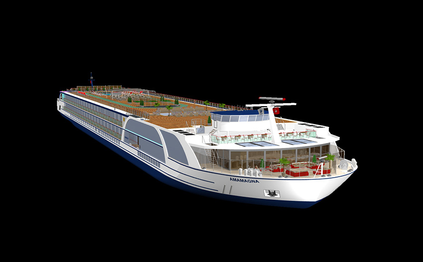
Artist Rendering AmaMagna courtesy AmaWaterways
Double-Wide
River Cruise Ship

No, we haven't changed from writing about cruise ships to writing about motor homes. 

We've been cruising for over 30 years and the one thing that we've gotten used to is an industry built on innovation. We never thought we'd be writing an article about a double-wide river cruise ship. To date, all river cruise ships were the same width - some were longer.

Just one day after christening their latest river cruise ship, AmaWaterways announced plans for AmaMagna, which will be their biggest ship launched in 2019.  In a company press release,  the line indicated that ship would be twice the width of traditional European river ships, representing a "new concept designed to elevate the modern luxury market".

Despite its expanded width, plans call for AmaMagna to only accommodate an additional 34 guests, bringing the capacity to 194.  Highlights of the new river ship include multiple dining options, including a glass-enclosed restaurant, an open-water sports platform, complete with zodiac boats, canoes and recreational equipment, and the majority of cabins with more than 300 square feet.

Additional amenities include a large heated sundeck swimming pool with whirlpool and sky bar, a spacious spa area with new treatments, a fitness room large enough for small group classes and generous common areas designed to accommodate a variety of onboard events.
As the luxury river cruise market continues to grow, we want to carry on as the leader in industry innovation. While this new double-width concept has been on the table for some time, we believe, given the unique demand that exists, that now is the perfect moment to introduce this style of ship,” said Rudi Schreiner, president and co-owner of AmaWaterways. 
AmaMagna will provide guests with generous personal space, the freedom of multiple dining choices and exceptional stateroom comfort. Combining this with our award-winning cuisine, noteworthy shore excursions and remarkable onboard service, we feel this ship is a game-changer.
If you've never sailed on a river cruise ship in Europe, you might not be aware that ships need to traverse a series of locks during a typical journey. Most river cruise ships are designed in such a way not to waste any space and just fit into the locks, until now.  AmaMagna's width will limit where the ship can be deployed.  Initial deployment is planned for the Danube river.

As with any innovation, some people will love the idea while others will hate it - perhaps there is also room somewhere in between.  We applaud AmaWaterways for taking the chance to introduce something new to the industry.  We wish them success with this new adventure.   We'd love to hear your feedback.


Additional Reading:

Complete Press release (AmaWaterways)
List of Locks Along the Rivers
AmaMagna First Look - ship model & Deck Plans (CLIA)
Vahali Shipyards (ship builder for AmaMagna)


@ChrisPappinMCC

Follow Us On


Sign-up for Exclusive Email Offers


Saturday, May 6, 2017

2017 Hurricane Preparedness Mini-Series Summary


Once again we have created a mini-series of blog posts on probably one of the most important topics we write about each year - Hurricane Preparedness. We have posted the entire series in advance of the actual kick-off of the week-long educational event sponsored by NOAA.

Each day during Hurricane Preparedness Week, we'll feature a theme on social media.  Follow us on Facebook and Twitter for the daily posts.   Click on links and images for various resources to help you learn about hurricanes and how to be better prepared.  

Even if you don't live in an area of the country which is subject to hurricanes, you may either travel there on vacation or experience weather related to the tropical storms (such as tornadoes that are spawned as a result of the cyclone).


America's PrepareAthon!


Read Entire Series (Click Here)


Hurricane Preparedness Week 2017

Hurricane Preparedness Week: 

May 7-13, 2017

#ItOnlyTakesOne
#HurricaneStrong

 Click Here for Mini-Series Summary

"It only takes one storm to change your life and community. Tropical cyclones are among nature’s most powerful and destructive phenomena. If you live in an area prone to tropical cyclones, you need to be prepared. Even areas well away from the coastline can be threatened by dangerous flooding, destructive winds and tornadoes from these storms."  ~NOAA


The goal of NOAA's Hurricane Preparedness Web site is to inform the public about the hurricane hazards and provide knowledge which can be used to take ACTION. This information can be used to save lives at work, home, while on the road, or on the water.

 [Click Image for Day's Hurricane Preparedness Blog Page]

Hurricane Hazard Risks


Click for Owlie & Other Kids Resources
A hurricane is a type of tropical cyclone or severe tropical storm that forms in the southern Atlantic Ocean, Caribbean Sea, Gulf of Mexico, and in the eastern Pacific Ocean. A typical cyclone is accompanied by thunderstorms, and in the Northern Hemisphere, a counterclockwise circulation of winds near the earth’s surface.

Every year, hurricanes put communities at risk of catastrophic damage from storm surges, flooding, high winds, and tornadoes.  During National Hurricane Preparedness Week, we rededicate ourselves to preventing loss of life and damage to property by raising awareness about hurricane hazards and taking action to protect our families, our homes, and our neighborhoods.


Click Here to Learn More
Hurricane Preparedness Week 2017
May 7th through May 13th 

For additional information about hurricanes, including useful links, 
see the static  "Hurricane Zone" tab above.

6 Chances to See Hurricane Hunter Aircraft


East Coast Tour – May 7-12  (click image to enlarge)

Hurricane Preparedness
East Coast Awareness Tour
Week of May 7th

Public invited to tour Air Force Reserve “Hurricane Hunter” aircraft


The NOAA Hurricane Hunters have an exciting and important activity next week -- a hurricane awareness tour! In an effort to build a Weather-Ready Nation, NOAA’s hurricane experts will tour six eastern cities in the U.S. and Canada to raise awareness about the importance of preparing for the upcoming hurricane season.

“Now is the time to prepare for the upcoming hurricane season – have your supplies ready and know where you will go when safe shelter is needed,” said Rick Knabb, Ph.D., director, NOAA’s National Hurricane Center, who will lead the tour. “With advanced planning, communities can better take a hit from nature and recover more quickly. Don’t wait for a storm to threaten – by then it may be too late.” 

Tour Schedule:
Public tour schedule (all times 2:30 pm to 5:00 pm except Gander)


  • Sun., May 7: Gander International Airport, Gander, Newfoundland, Canada, 10:30 am to 3:00 pm 
  • Mon., May 8: Long Island MacArthur Airport, N.Y.
  • Tue., May 9: Reagan National Airport, Washington, D.C. (ends at 4:30 pm) 
  • Wed., May 10: Raleigh-Durham Intl. Airport, Raleigh, N.C. 
  • Thu., May 11: Orlando Executive Airport, Orlando, Fla. 
  • Fri., May 12: Opa Locka Executive Airport, Opa Locka, Fla. 

NOAA has been conducting hurricane awareness tours like this for over 35 years, alternating between Gulf and Atlantic coasts.  Hurricane season begins June 1st and continues through November 30th. The tour will include a U.S. Air Force Reserve WC-130J hurricane hunter aircraft, which flies directly through the eye of a storm, the NOAA G-IV aircraft, which flies ahead of a storm, and at two stops, the NOAA WP-3D Orion research aircraft.   Read more...

The aircraft is piloted by officers of the NOAA Corps — one of the seven uniformed services of the United States — and based at the NOAA Aircraft Operations Center, located at MacDill Air Force Base in Tampa, Florida.  NOAA’s mission is to understand and predict changes in the Earth's environment, from the depths of the ocean to the surface of the sun, and to conserve and manage our coastal and marine resources. Visit them on Facebook.


Read Entire Series (Click Here)


More links and information about tropical storms and other weather conditions can be found in the Weather & Hurricane Zone tabs above.


Hurricane Preparedness Week:   
May 7-13, 2017

2017 Hurricane Preparedness - Check on Neighbor


Check on Your Neighbors (Click Here)


Hurricane
Information

TV, web, social media - only use trusted sources for the latest hurricane information! NOAA's National Hurricane Center is your official source for Atlantic hurricane forecasts and the issuance of hurricane watches and warnings. In addition, your local NOAA National Weather Service forecast office provides information regarding the expected impacts from the storm for your area.

Plan with neighbors to help each other and share resources. Almost half of Americans expect to rely a great deal on their neighbors after a disaster. Start the conversation now with these

Neighbor Helping Neighbor strategies

http://www.hurricanes.gov/
http://hurricanes.gov/prepare

https://www.nhc.noaa.gov/?cpac


We continue our coverage of the 2017 Hurricane Preparedness Week by looking at the tropical weather forecasting process. 

What's New in Hurricane Forecasting (NOAA)


6 Hour
Forecast Cycle
When a storm threatens the following occurs
0:00
A new hurricane forecast cycle begins.
0:45
Receive the location of the center of the hurricane.
1:00
Initialize or start the hurricane models with the storm's location and intensity
1:20
Receive model guidance and prepare a new hurricane forecast.
2:00
Coordinate with National Weather Service and Dept. of Defense.
3:00
Issue the full hurricane advisory package.
ISSUANCE TIME:
5am EDT (4 CDT)
11am EDT (10 CDT)
5pm EDT (4 CDT)
11pm EDT (10 CDT)
3:15
Participate in the Federal Emergency Management Agency (FEMA) conference call with the affected states.
6:00
A new hurricane forecast cycle begins.
**
When a Watch or a Warning is issued, intermediate advisories are initiated.


Source:  NHC: Forecast Process (Learn More)

Part of the mission of the National Weather Service (NWS) Tropical Prediction Center (TPC) is to save lives and protect property by issuing watches, warnings, forecasts, and analyses of hazardous weather conditions in the tropics. This section provides information about the roles of those responsible for providing hurricane information to emergency managers and decision makers.

The TPC is comprised of the National Hurricane Center (NHC), the Tropical Analysis and Forecast Branch (TAFB), and the Technical Support Branch (TSB). During hurricane season, the latter two provide support to the NHC.

The local NWS Weather Forecast Offices (WFOs) in hurricane-prone areas are also important participants in the forecast process.

OBSERVATION
Observations including satellites, buoys, reconnaissance aircraft, and radar are the basis for all forecast and warning products issued by the NHC. Quality, quantity, and timeliness of remote sensing observations are critical for accurate and timely forecasts and warnings.

ANALYSIS
The various observations are checked for quality, analyzed, and put into a suite of computer models. 

MODEL GUIDANCE AND INTERPRETATION
The computer models take in the observations and perform millions of calculations to generate predictions of hurricane behavior and the general conditions of the atmosphere in which the hurricane is embedded. The model results are packaged as guidance for the appropriate national centers and local offices and for evaluation and use in the NWS's forecast and warning process.

COORDINATION WITHIN THE NWS
Forecasts and warnings are coordinated between the national centers and local forecast offices to provide consistency, which is critical during severe weather episodes.

Read Entire Series (Click Here)

More links and information about tropical storms and other weather conditions can be found in the Weather & Hurricane Zone tabs above.


Hurricane Preparedness Week:   
May 7-13, 2017

2017 Hurricane Preparedness - After the Storm


Recovering from Disaster
Final In the 2017 Series


Rebuilding After the Storm


We conclude our coverage of the 2017 Hurricane Preparedness Week by looking at recovering from the storm.  Three organizations come to mind when you think about the aftermath of a hurricane or other natural disaster:  FEMA, Red Cross, and the National Guard.  There are many other organizations and individuals that also play a key role in providing immediate and long-term assistance to those impacted by the hazards of hurricanes and other natural disasters.


Recovering from a disaster is usually a gradual process with the first concern being immediate search and recovery while keeping safety in mind.   After the area has been made safe, the recovery process can begin.  Here are some resources that are helpful after the storm:
Even with all the scientific advances in recent years, it is still impossible to predict how many storms will occur in a given year and what communities lie in their path.   Just like in sports, the best defense is a good offense.

NOW is the TIME to PREPARE

Not the storm you are looking for?  Click Image or Here

In this case, Hurricane Preparedness is that secret play that can make the difference in loss of property and lives.  It is for that reason that we have participated with NOAA, FEMA and other organizations in sharing these public service announcements.   We have been covering hurricane preparedness for years, so if you still need more information, you can check out some of our other articles which can be found via links in our Hurricane Zone page.

We are reminded about some disturbing news, published by the American Red Cross, about how Despite Sandy’s Damage, U.S. Coastal Residents Still Unprepared. 

An infographic on the survey findings can be viewed here.

American Red Cross Urges People to Get Ready for Hurricanes

Read Entire Series (Click Here)
More links and information about tropical storms and other weather conditions can be found in the Weather & Hurricane Zone tabs above.


Hurricane Preparedness Week:   
May 7-13, 2017

2017 Hurricane Preparedness - Being Prepared


Prepare Written Plan (Click Here)


Hurricane
Planning

The time to prepare for a hurricane is before the season begins, when you have the time and are not under pressure. If you wait until a hurricane is on your doorstep, the odds are that you will be under duress and will make the wrong decisions. Take the time now to write down your hurricane plan. Know where you will ride out the storm and get your supplies now. You don’t want to be standing in long lines when a Hurricane Watch is issued. Those supplies that you need will probably be sold out by the time you reach the front of the line. Being prepared, before a hurricane threatens, makes you resilient to the hurricane impacts of wind and water. It will mean the difference between your being a hurricane victim and a hurricane survivor.

http://www.ready.gov/make-a-plan http://hurricanes.gov/prepare

http://www.prh.noaa.gov/cphc/


Click on this interactive image to learn more about being prepared for Hurricanes and other Disasters

NOW is the TIME to PREPARE

There's still time before the official start of Hurricane Season 2017 in the Atlantic Basin.   We have already had our first Tropical Storm, Arlene, which formed on April 20th. Hopefully this series of articles and the resources that we've shared will assist you in keeping your family and property safe this season.   We may have an slightly below-average season forecast, but it only takes one storm....  

Our final article will take a look at what to do after the storm.  Thank you for taking this seriously.


Read Entire Series (Click Here)
More links and information about tropical storms and other weather conditions can be found in the Weather & Hurricane Zone tabs above.


Hurricane Preparedness Week:   
May 7-13, 2017