Showing posts with label active storms. Show all posts

Monday, January 31, 2011

Historic Snowstorm Predicted


The Northeastern part of the United States has already had some major snow accumulation this year, but those storms may pale next to the one that National Weather Service is predicting for the Midwest.    Light snow has already begun falling over the region, but that is only the first wave according to predictions.

NWS Forecast:   Potentially Historic Snowstorm Expected through Wednesday

The storm is being called "historic" and comparisons are being made to a major storm in late January, 1967.   Some areas of the region are expected to get almost two feet of snow from this system.

I'd rather be sailing ...
Municipalities, like Chicago, are preparing for the worst, rolling out emergency snow removal plans and encouraging residents to prepare now for the storm.   All but essential travel will be recommended if the storm reaches the expected levels.

Airlines and airports are also bracing for what will become a logistical nightmare as air traffic comes to a halt and snow removal crews battle to stay ahead of the storm.   The most dangerous aspect of the storm will be the high winds which will accompany the snow, making it virtually impossible to see.

Cruise passengers may be impacted by the storm as travel delays and cancellations have a ripple effect across the country.   For those traveling, be sure to call ahead to your carrier to see how the storm impacts you.

Major weather events like this are perfect commercials for travel insurance.  Be sure to read your policy and know what coverage and assistance you can expect from your carrier and insurance company.    It might be too late to get ahead of the storm, but that too should be considered.

Here are some resources that can come in handy as the storm intensifies.

NWS - Local Weather
National Weather Hazards

Friday, January 7, 2011

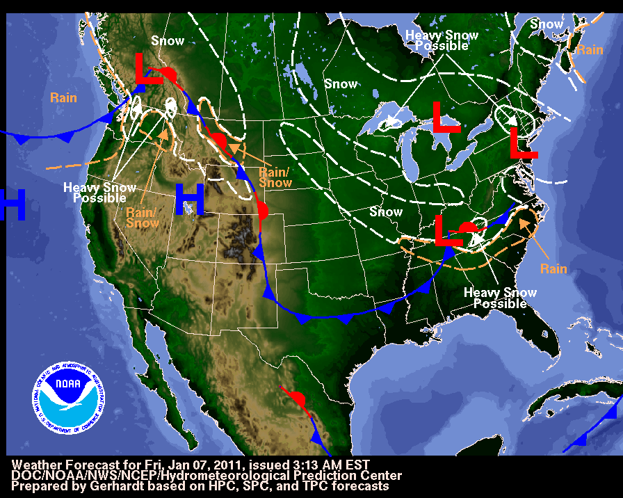
Northeast Braces for Another Snowy Weekend

National Weather Forecast Courtesy NOAA (click for more details)

Northeast Regional Snow Potential (NOAA)
NORTHEAST BRACES FOR
ANOTHER SNOWSTORM


NWS and other weather forecasters are predicting another major snow storm for the Northeastern part of the United States starting today.

 Major airlines have issued waivers for change fees in the affected areas.   Expect flight delays as the snow has already begun falling in parts of the region.

It appears that for the most part the snow will be light, but some areas are expected to get the brunt of the storm resulting in heavier accumulations.  There is an element of uncertainty due to the current conditions, so this is one storm that needs to be monitored closely for up-to-the-minute changes.

At press time we are not aware of any cruise line changes related to the storm but obviously anyone traveling in the region could be subject to delays.   We always recommend leaving early and always travel with trip insurance, especially during the winter months or hurricane season.


Tuesday, September 14, 2010

Current Atlantic Tropical Weather Outlook

Atlantic Graphical Tropical Weather Outlook

We are monitoring two active tropical storms at the moment:

Hurricane Igor & Hurricane Julia 

Click the following links for latest updates on these hurricanes 


Not the storm you are looking for?  Click Image or Here

Tropical Storm Julia Forms in Atlantic

Igor Expected to Become a Hurricane 

UPDATE:   This storm did strengthen into named Tropical Storm Karl and later Hurricane Karl

Tropical Storm Karl Heading Toward Yucatan

Meanwhile ... there appears to be another potential storm forming in the Northwest Caribbean Sea.  This is shown in the graphic from the NHC above as #1.   There is a medium chance that this depression will form into a tropical cyclone in the near future.


While there are no land advisories for the two hurricanes at the present time, this yet unnamed storm has the potential of producing heavy rains in the Caribbean.   No cruise ship advisories have been released at this time, but this latest storm has the potential of altering schedules should it intensify.


800 AM EDT TUE SEP 14 2010

FOR THE NORTH ATLANTIC...CARIBBEAN SEA AND THE GULF OF MEXICO...


THERE IS A MEDIUM CHANCE...40 PERCENT...
OF THIS SYSTEM BECOMING A TROPICAL
CYCLONE DURING THE NEXT 48 HOURS. 
 
REGARDLESS OF DEVELOPMENT... 
 
LOCALLY HEAVY RAINFALL IS POSSIBLE OVER PORTIONS OF JAMAICA...
CUBA...THE CAYMAN ISLANDS...AND THE YUCATAN PENINSULA DURING THE
NEXT DAY OR TWO.  THESE RAINS COULD CAUSE LIFE-THREATENING FLASH
FLOODS AND MUD SLIDES...ESPECIALLY IN AREAS OF MOUNTAINOUS TERRAIN. 


We will continue our coverage of tropical weather throughout the hurricane season.  

Saturday, August 7, 2010

Tropical Storm Estelle in East Pacific

The GOES-11 satellite captured a visible image of Tropical Depression 7E (appearing as the large swirl of clouds right/center) off the western Mexico coast on Friday, August 6 at 1500 UTC (11 a.m. EDT).
Credit: NASA/GOES Project


UPDATE:   800 AM PDT SUN AUG 08 2010

...ESTELLE WEAKENING...


Tropical Depression 7E has now become Tropical Storm Estelle off the West coast of Mexico. Other than an initial band of heavy rain, the storm poses no immediate threat to land.

We will continue to monitor this storm, in case it changes direction or intensity, but at the current forecast rate, it should become a remnant low by later in the week.

NHC issuing advisories on TS COLIN and TS ESTELLE 

800 AM PDT SAT AUG 07 2010

...ESTELLE CONTINUES MOVING WESTWARD...

Current Watches & Warnings
There are no current Coastal Watches or Warnings in Effect

Discussion & Outlook


SUMMARY OF 800 AM PDT...1500 UTC...INFORMATION (07 Aug)

LOCATION...17.1N 107.6W
ABOUT 255 MI...410 KM WSW OF MANZANILLO MEXICO
MAXIMUM SUSTAINED WINDS...50 MPH...85 KM/HR
PRESENT MOVEMENT...W OR 280 DEGREES AT 9 MPH...15 KM/HR
MINIMUM CENTRAL PRESSURE...1000 MB...29.53 INCHES


MAXIMUM SUSTAINED WINDS REMAIN NEAR 50 MPH...85 KM/HR...WITH HIGHER
GUSTS.  SOME STRENGTHENING IS FORECAST DURING THE NEXT 24
HOURS...ALTHOUGH THE STORM COULD START TO WEAKEN BY EARLY NEXT
WEEK.  

TROPICAL STORM FORCE WINDS EXTEND OUTWARD UP TO 50 MILES...85 KM
FROM THE CENTER.


HAZARDS AFFECTING LAND

NONE.

There are no cruise ships in the immediate vicinity of Estelle at this time.


Tropical Storm Resources (click links below)
Tropical Storm ESTELLE
East Pacific Tropical Weather Outlook National Weather Service
East Pacific Tropical Weather Discussion Hurricane Preparedness
Graphical Tropical Weather Outlook (EPAC) Real-Time Hurricane Information
Active Storms  NOAA Satellites & Information
NASA: Latest Storm Images WMO Severe Weather Information Centre
Real-time Monitoring (E. Pacific) The Saffir-Simpson Hurricane Wind Scale
Real-time Weather Sites Real-Time Cruise Ship Tracking


Tropical Storm Colin Heads Towards Bermuda

5-Day Forecast Cone for Tropical Storm Colin (Credit: NOAA NHC)
UPDATE:  1100 AM AST SUN AUG 08 2010
...COLIN MOVING NEAR BERMUDA...WEAKENS TO A TROPICAL DEPRESSION...
 1100 AM AST SAT AUG 07 2010
...COLIN HESITATES BUT EXPECTED TO RESUME A NORTHWARD MOTION LATER TODAY...
Tropical Storm Colin is now forecast to bring heavy rains and gusty winds to Bermuda before it heads into the north Atlantic this weekend.  The storm had become a remnant low on August 5th, but it has regained strength and now threatens Bermuda once again.   NASA's TRMM Satellite captured images of the storm at different stages of its development.  

NHC issuing advisories on TS COLIN and TS ESTELLE 

As a reminder,  Hurricane Season runs from June 1 - November 30.    Our blog has RSS feeds from the NHC which will bring you current advisories.   Our Weather tab (above) has additional links for monitoring tropical weather and other dangers which could impact your cruise vacation.

Current Watches & Warnings


A TROPICAL STORM WATCH IS IN EFFECT FOR...
Bermuda
A TROPICAL STORM WARNING MEANS THAT TROPICAL STORM CONDITIONS ARE
EXPECTED SOMEWHERE WITHIN THE WARNING AREA WITHIN 36 HOURS.
A TROPICAL STORM WATCH MEANS THAT TROPICAL STORM CONDITIONS ARE
POSSIBLE WITHIN THE WATCH AREA...GENERALLY WITHIN 48 HOURS.

BERMUDA WEATHER ADVISORY: 

TS Colin is a threat to Bermuda. Conditions will deteriorate today with wind and shower activity increasing. Tropical storm conditions are expected to develop later this this evening, and persist through early midday Sunday as Colin passes just west of the Island. Conditions gradually improve Sunday afternoon. Please check for updates regularly. 

Discussion  &  Outlook
 
SUMMARY OF 1100 AM AST...1500 UTC...INFORMATION (08Aug)

LOCATION...32.0N 65.6W
ABOUT 50 MI...80 KM WSW OF BERMUDA
MAXIMUM SUSTAINED WINDS...35 MPH...55 KM/HR
PRESENT MOVEMENT...N OR 360 DEGREES AT 12 MPH...19 KM/HR
MINIMUM CENTRAL PRESSURE...1013 MB...29.91 INCHES
  
MAXIMUM SUSTAINED WINDS ARE NEAR 35 MPH...55 KM/HR...WITH HIGHER
GUSTS.  LITTLE CHANGE IN STRENGTH IS FORECAST DURING THE NEXT 48
HOURS.  HOWEVER...COLIN COULD DEGENERATE TO A TROUGH OF LOW PRESSURE
DURING THE NEXT DAY OR SO.
 
Cruise Line Advisories
None at this time 
The following ships are in the area of the Tropical Storm: 
Norwegian Dawn, Holland America Veendam, Royal Caribbean Explorer of the Seas

We will monitor the storm and provide any Cruise Line Updates

HAZARDS AFFECTING LAND

WIND...TROPICAL-STORM-FORCE WINDS MAINLY IN GUSTS ARE POSSIBLE OVER
BERMUDA TODAY.

STORM SURGE...COLIN IS EXPECTED TO PRODUCE SOME COASTAL FLOODING
AND LARGE WAVES IN BERMUDA...PARTICULARLY ALONG SOUTH-FACING
BEACHES.

RAINFALL...COLIN IS EXPECTED TO PRODUCE TOTAL RAINFALL ACCUMULATIONS
OF 1 TO 3 INCHES IN BERMUDA.
 
Tropical Storm Resources (click links below)
Tropical Storm COLIN
Atlantic Tropical Weather Outlook National Weather Service
Atlantic Tropical Weather Discussion Hurricane Preparedness
Graphical Tropical Weather Outlook (ATL) Real-Time Hurricane Information
Active Storms  NOAA Satellites & Information
NASA: Latest Storm Images WMO Severe Weather Information Centre
Real-time Monitoring (Atlantic) The Saffir-Simpson Hurricane Wind Scale
Real-time Weather Sites Real-Time Cruise Ship Tracking