Magnitude 8.8 Earthquake
Offshore Maule, Chile
Saturday, February 27, 2010
03:34:14 AM at epicenter
A powerful Magnitude 8.8 Earthquake hit offshore Maule, Chile early Saturday morning damaging buildings, bridges, and vehicles while causing severe injury and death in its path. President-elect Sebastian Pinera said more than 120 people died, but that number was rising quickly.
A series of after shocks continues to strike the continent of South America. The quake shook buildings in
Argentina's capital of
Buenos Aires, and was felt as far away as
Sao Paulo in Brazil — 1,800 miles (2,900 kilometers) to the east.
Charities and governments of the world have mobilized to provide humanitarian aide to Chile. Our thoughts and prayers go out to the people impacted by this tragedy.
(see below for impact on cruise ships)

THIS BULLETIN APPLIES TO AREAS WITHIN AND BORDERING THE PACIFIC
OCEAN AND ADJACENT SEAS...
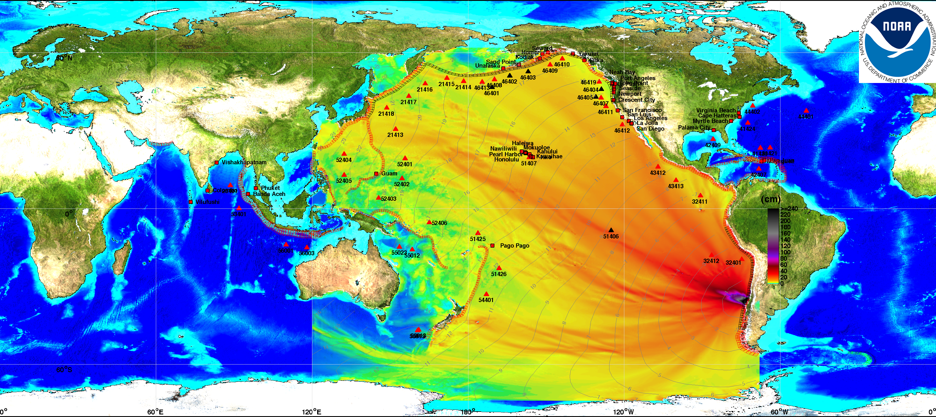
This energy map provided courtesy of
West Coast & Alaska Tsunami Warning Center

NOAA Interactive map (click here)
UPDATE: Sunday, February 28th
TSUNAMI WARNINGS LIFTEDAs the tsunami waves, generated by the Chile earthquake, reached the shores of Japan and Russia there was a sigh of relief across the globe. The waves were smaller than expected causing minimal flooding in most cases.
A WIDESPREAD TSUNAMI WARNINGIS IN EFFECT FOR ...
CHILE / PERU / ECUADOR / COLOMBIA / ANTARCTICA / PANAMA /
COSTA RICA / NICARAGUA / PITCAIRN / HONDURAS / EL SALVADOR /
GUATEMALA / FR. POLYNESIA / MEXICO / COOK ISLANDS / KIRIBATI /
KERMADEC IS / NIUE / NEW ZEALAND / TONGA / AMERICAN SAMOA /
SAMOA / JARVIS IS. / WALLIS-FUTUNA / TOKELAU / FIJI /
AUSTRALIA / HAWAII / PALMYRA IS. / TUVALU / VANUATU /
HOWLAND-BAKER / NEW CALEDONIA / JOHNSTON IS. /
SOLOMON IS. /NAURU / MARSHALL IS. / MIDWAY IS. / KOSRAE /
PAPUA NEW GUINEA /POHNPEI / WAKE IS. / CHUUK / RUSSIA /
MARCUS IS. / INDONESIA /N. MARIANAS / GUAM / YAP / BELAU /
JAPAN / PHILIPPINES /CHINESE TAIPEI
RSS feeds have been added (right column) bringing you latest updates from the
Pacific Tsunami Warning Center.
Hawaii Under Tsunami Warning
UPDATE: THE TSUNAMI WARNING IS CANCELLED FOR THE STATE OF HAWAII EFFECTIVE
AT 0138 PM HST. (more information)
A tsunami has been generated as a result of the quake in Chile. The tsunami could cause damage along coastlines of all islands in the state of Hawaii. Urgent action should be taken to protect lives and property.
THE ESTIMATED ARRIVAL TIME IN HAWAII
OF THE FIRST TSUNAMI WAVE IS
1105 AM HST SAT 27 FEB 2010
Tsunami warning sirens awakened residents and tourists in Hawaii, Polynesia, and Tonga this morning. We received a report from friends in Maui that the first waves aren't expected until around 11 AM HST (4 PM EST), so they have plenty of time to head for higher ground. Stores were crowded early this morning as residents gathered emergency supplies.
Hilo airport to close; other airports remain openHawaii could face its largest waves since 1964 according to Charles McCreery, director of the
Pacific Tsunami Warning Center. Officials evacuated people and boats near the water and closed shore-side
Hilo International Airport at 6 A.M. today in conjunction with preparations for the arrival of a possible tsunami. Anyone with flights booked to Hilo are advised to contact their airline.
Other state airports remain open at this time and flight operations have not been impacted.
French Polynesia on tsunami alert after Chile quakeThe first wave was expected to hit the French Polynesian Gambier islands at 1550 GMT, then Tahiti at 1750 GMT and Bora Bora at 1815 GMT, the French Polynesia High Commissioner said in a statement.
"Danger will persist for at least two hours after the first wave hits and magnitudes could be rising," the statement said.
Residents were asked to move away from the shores and seek high ground, it added.
North American Pacific Coast under Tsunami Warning
Estimated Times for Arrival for North American Pacific coast can be viewed by clicking
here.
Link to Printable Message
What is a Tsunami?A tsunami is a series of long ocean waves. Each individual wave crest can last 5 to 15 minutes or more and extensively flood coastal areas. The danger can continue for many hours after the initial wave as subsequent waves arrive. Tsunami wave heights cannot be predicted and the first wave may not be the largest. Tsunami waves efficiently wrap around islands. All shores are at risk no matter which direction they face. The trough of a tsunami wave may temporarily expose the seafloor but the area will quickly flood again. Extremely strong and unusual nearshore currents can accompany a tsunami. Debris picked up and carried by a tsunami amplifies its destructive power. Simultaneous high tides or high surf can significantly increase the tsunami hazard. (
More information here)
Issued by the Joint Australian Tsunami Warning Centre (JATWC) at 6:50 AM EDT on Sunday 28 February 2010. Maps showing the affected areas are on the
Bureau web site.
We will provide continuing coverage of the tsunami danger to land and cruise ships in its path. This tsunami has the potential of threatening every nation around the Pacific Ocean — roughly a quarter of the globe.
Japan Issues Major Tsunami WarningWhile Hawaii seems to have dodged the bullet, Japan is still predicting a major tsunami event. A major tsunami means waves will be in excess of 3 meters. (
current advisories)
Important Links:
There is a lot of detailed information on each of the Tsunami Warning Center websites so be sure to check out the various links for up to the minute information for your area of interest.
(
Chile event Feb 27, 2010 )Propagation animationDART® real-time tsunami monitoring systems, developed by PMEL, are positioned at strategic locations throughout the ocean and play a critical role in tsunami forecasting.
DART® (Deep-ocean Assessment and Reporting of Tsunamis)
IMPACT on CRUISE SHIPSLive Cruise Ship and Ocean Liner Tracking:
Interactive tracking map See where ships are relative to tropical storms.
Holland America Ships Safe (issues following statement)
The four Holland America Line ships that are operating in the Pacific Ocean at this time were not impacted. The ms Veendam was in protected waters in Chile when the earthquake occurred while the ms Zaandam and ms Maasdam are in open ocean and will remain there until the risk of the tsunami wave has passed. ms Rotterdam is safely docked in Puerto Caldera. We will continue to closely monitor the situation and make adjustments to itineraries if needed.
At Holland America Line, the safety and security of our guests and crew is our top priority.
Holland America Cruise Line Travel Advisory (Monitor this link for updates)
Princess Cruises Monitoring Chile Earthquake / Tsunami (issues following statement)
We are aware of various tsunami warnings as a result of the magnitude 8.8 earthquake in Chile this morning. Any potential impact to our fleet has been reviewed thoroughly. As a result, some changes to port calls today and tomorrow have been made to ensure the safety of our passengers and crew. Passengers are being kept updated onboard.
Earthquake in Chile and Tsunami Warnings (complete details of 2/27 advisory)
Update March 1st:Star Princess departure from Valparaiso, Chile delayed due to flight problems at Santiago Airport. Passengers from both cruises being allowed onboard. Read complete details:
Update on Star Princess Turnaround in Valparaiso, Chile -- March 2 Princess Cruises News (monitor this link for any additional advisories)
The Port of Auckland was closed today and five ships were ordered to move into deep water until the threat of a tsunami passed.
Dawn Princess arrived earlier and many passengers had already gone ashore when it was ordered out to sea. Don't worry, it will be back to collect the passengers in time to continue to their next port of call.
Info for Norwegian Sun & Pride of America GuestsPride of America Guests
Because of a tsunami warning, the Port of Honolulu has been closed. Pride of America which was scheduled to dock in Honolulu this morning will spend the day at sea until the port reopens. The safety of the ship's passengers and crew is of the utmost importance. While at sea, this situation does not in any way compromise the safety and security of our passengers and crew.
At this time, we anticipate that the port will re-open at 5 pm local time in Hawaii. Pride of America should be alongside shortly after that and we expect that the next cruise will depart later this evening. Guests traveling to Honolulu or already in Honolulu for the ship's next voyage should call Norwegian Cruise Line at 800-327-7030.
Norwegian Sun Guests
Norwegian Sun is in Montevideo, Uruguay today as scheduled. The ship will arrive in Buenos Aires, Brazil tomorrow as scheduled and embark guests on the February 28, 2010 cruise. We are closely monitoring the situation in Chile and will keep guests updated as to any changes to the current scheduled itinerary.
Norwegian Cruise Line Advisory (monitor this link for any changes)
Celebrity Cruises Monitoring Chile Earthquake / TsunamiCelebrity Infinity - 14-Night South America, Buenos Aires to Valparaiso is scheduled to depart February 28, 2010. As of this writing it Celebrity has not modified the itinerary. We will continue to monitor the situation and provide updates.
Here are some additional weather links which may be helpful.NWS - Local WeatherNWS - MexicoCabo San Lucas (weather.com)
Acalpulco (weather.com)
Servicio Meteorológico Nacional (Spanish)My thanks to the various Tsunami Warning Centers (above) which were my source for diagrams used in this post. This information has been provided in the interest of public education and awareness of the impending danger.
Please stay safe - stay away from the water when the tsunami approaches.


