Showing posts with label Acapulco. Show all posts

Saturday, June 13, 2015

CARLOS Third Hurricane 2015 East Pacifc

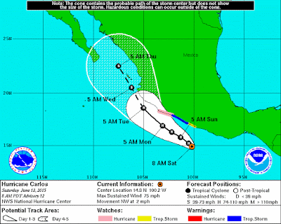
Hurricane Carlos
Other images: 5-Day track off3-Day track off3-Day track onInteractive

Hurricane  CARLOS

Tropical Depression Three-E formed Wednesday, well south of southwest Mexico and was upgraded to a Tropical Storm on Thursday.  Today (Saturday) it has become the third Hurricane of  the East Pacific 2015 Hurricane Season. Hurricane Carlos is forecast to strengthen a bit more, but will likely remain a Category 1 hurricane.

NHC issuing advisories on Hurricane CARLOS


Full coverage of this, and all tropical storms, can be found on our Hurricane Zone page.   There are RSS feeds from the National Hurricane Center posted there giving you up to the minute information.   For storms that impact cruises, we will bring you information on those details as well.  Please bookmark that page for further reference during the Hurricane Season which runs now through November 30th.


HURRICANE CARLOS
...HURRICANE HUNTER AIRCRAFT FINDS CARLOS HAS REGAINED HURRICANE
STATUS JUST OFFSHORE OF THE SOUTH-CENTRAL COAST OF MEXICO...
WIND:
75 mph (120 km/h) with higher gusts
WATCHES/ WARNINGS:
A Hurricane Watch is in effect for...
* West of Punta San Telmo to Playa Perula

A Tropical Storm Warning is in effect for...
* Punta San Telmo to Lazaro Cardenas

Interests elsewhere along the southwest coast of Mexico should
monitor the progress of Carlos.

SHIP IMPACT:
NO IMPACT REPORTED AT THIS TIME
 

A Hurricane Warning means that hurricane conditions are expected
somewhere within the warning area.  A warning is typically issued
36 hours before the anticipated first occurrence of
tropical-storm-force winds, conditions that make outside
preparations difficult or dangerous.  Preparations to protect life
and property should be rushed to completion.
 
A Hurricane Watch means that hurricane conditions are possible
within the watch area.  A watch is typically issued 48 hours
before the anticipated first occurrence of tropical-storm-force
winds, conditions that make outside preparations difficult or
dangerous.
     
A Tropical Storm Warning means that tropical storm conditions are
expected somewhere within the warning area within 36 hours.

A Tropical Storm Watch means that tropical storm conditions are
possible within the watch area, generally within 48 hours.

Storm Archive       Graphics Archive


MORE INFORMATION ABOUT HURRICANES (CLICK HERE)

HAZARDS AFFECTING LAND

WIND:  Tropical Storm conditions are expected within the warning
area today.  Hurricane conditions are possible within the hurricane
watch area by Tuesday morning.

RAINFALL:  Carlos is expected to produce rains in the Mexican states
of Guerrero, Michoacan, Colima, Jalisco and Nayarit, with rainfall
accumulations of 6 to 10 inches possible through Wednesday, and
maximum totals of 15 inches possible.  These rains may produce life-
threatening flash floods and mudslides, especially in areas of
higher terrain.

SURF:  Swells associated with Carlos will affect the coasts of
southern and southwestern Mexico during the next few days.  These
swells could cause life-threatening surf and rip currents.  Please
consult products from your local weather office.

HISTORICAL NOTES
 

400 PM CDT WED JUN 10 2015

...NEW TROPICAL DEPRESSION FORMS TO THE SOUTH OF MEXICO...

1000 AM CDT THU JUN 11 2015

...TROPICAL STORM CARLOS FORMS SOUTH OF MEXICO...

1000 AM CDT SAT JUN 13 2015

...HURRICANE WATCH AND TROPICAL STORM WARNING ISSUED FOR
PARTS OF SOUTHWESTERN MEXICO...

1000 AM CDT SUN JUN 14 2015

...CARLOS WEAKENS TO A TROPICAL STORM JUST SOUTH OF MEXICO...
...EXPECTED TO RESTRENGTHEN INTO A HURRICANE BY MONDAY...


100 PM CDT MON JUN 15 2015

...HURRICANE HUNTER AIRCRAFT FINDS CARLOS HAS REGAINED HURRICANE
STATUS JUST OFFSHORE OF THE SOUTH-CENTRAL COAST OF MEXICO...

Sunday, October 20, 2013

Raymond First Major Hurricane in East Pacific

Hurricane Raymond

  Hurricane Raymond
Category 3


  Hurricane Raymond
1100 AM PDT TUE OCT 22 2013

...AIR FORCE HURRICANE HUNTERS FIND RAYMOND WEAKER...
...HEAVY RAINFALL THREAT CONTINUES 
FOR PORTIONS OF SOUTH-CENTRAL MEXICO...
WIND:
DECREASED TO NEAR 90 MPH...150 KM/H...
WITH HIGHER GUSTS.
WATCHES/ WARNINGS:
A HURRICANE WARNING IS IN EFFECT FOR...
* TECPAN DE GALEANA TO LAZARO CARDENAS

A HURRICANE WATCH IS IN EFFECT FOR...
* ACAPULCO TO TECPAN DE GALEANA

A TROPICAL STORM WARNING IS IN EFFECT FOR...
* ACAPULCO TO TECPAN DE GALEANA
SHIP IMPACT:
Holland America Line Westerdam changes:
10/22 - 23 Puerto Vallarta, Mexico until 1:00 p.m. 
10/24  Huatulco, Mexico cancelled 
 
Storm Archive         Graphics Archive

 
Raymond, the 8th hurricane of the Pacific Hurricane Season and first major hurricane (category 3 or higher), has sustained winds of 125 miles per hour off the coast of Acapulco, Mexico, just south of Puerto Vallarta.


SUMMARY OF 500 AM PDT...1200 UTC...INFORMATION
----------------------------------------------
LOCATION...16.5N 102.0W
ABOUT 85 MI...140 KM SSW OF ZIHUATANEJO MEXICO
ABOUT 140 MI...230 KM W OF ACAPULCO MEXICO
MAXIMUM SUSTAINED WINDS...115 MPH...185 KM/H
PRESENT MOVEMENT...STATIONARY
MINIMUM CENTRAL PRESSURE...959 MB...28.32 INCHES
 
 
MAXIMUM SUSTAINED WINDS ARE NEAR 125 MPH...205 KM/H...WITH HIGHER
GUSTS. RAYMOND IS A CATEGORY THREE HURRICANE ON THE SAFFIR-SIMPSON
HURRICANE WIND SCALE. GRADUAL WEAKENING IS EXPECTED TO BEGIN ON
TUESDAY.
 
HURRICANE FORCE WINDS EXTEND OUTWARD UP TO 25 MILES...35 KM...FROM
THE CENTER...AND TROPICAL STORM FORCE WINDS EXTEND OUTWARD UP TO 80
MILES...130 KM. 
 
 
HAZARDS AFFECTING LAND
----------------------
RAINFALL...RAYMOND IS EXPECTED TO PRODUCE RAINFALL AMOUNTS OF 5 TO
10 INCHES WITH ISOLATED AMOUNTS OF UP TO 15 INCHES OVER THE MEXICAN
STATES OF GUERRERO AND MICHOACAN. THESE RAINS COULD PRODUCE LIFE-
THREATENING FLASH FLOODS AND MUD SLIDES.

WIND...TROPICAL STORM CONDITIONS ARE EXPECTED TO BEGIN IN PORTIONS
OF THE WARNING AREA TODAY. HURRICANE CONDITIONS MAY OCCUR IN
PORTIONS OF THE HURRICANE WARNING AREA LATER TODAY IF THE CENTER OF
RAYMOND MOVES CLOSER TO THE COAST THAN CURRENTLY FORECAST.

STORM SURGE...A STORM SURGE IS EXPECTED TO PRODUCE SIGNIFICANT
COASTAL FLOODING IN AREAS OF ONSHORE WINDS WITHIN THE WARNING
AREAS. NEAR THE COAST...THE SURGE WILL BE ACCOMPANIED BY LARGE AND
DESTRUCTIVE WAVES.

SURF...SWELLS GENERATED BY RAYMOND ARE AFFECTING PORTIONS OF THE
SOUTH-CENTRAL COAST OF MEXICO. THESE SWELLS ARE LIKELY TO CAUSE
LIFE-THREATENING SURF AND RIP CURRENT CONDITIONS. FOR MORE
INFORMATION...PLEASE CONSULT PRODUCTS FROM YOUR NATIONAL
METEOROLOGICAL SERVICE.
 
 Historical Data:

800 PM PDT SAT OCT 19 2013
 
...TROPICAL DEPRESSION FORMS SOUTH OF ACAPULCO...
...EXPECTED TO STRENGTHEN AND MOVE SLOWLY TOWARD THE COAST...
 
200 AM PDT SUN OCT 20 2013
 
...ANOTHER TROPICAL STORM SOUTH OF MEXICO...
 
200 PM PDT SUN OCT 20 2013
 
...RAYMOND EXPECTED TO BECOME A HURRICANE VERY SOON...
...HURRICANE WATCH AND TROPICAL STORM WARNING ISSUED FOR PART OF THE
MEXICAN COAST...
 
500 PM PDT SUN OCT 20 2013
 
...RAYMOND BECOMES A HURRICANE...
 
1100 PM PDT SUN OCT 20 2013
 
...RAYMOND HESITATES SOUTH OF THE COAST OF MEXICO...
...ALMOST A MAJOR HURRICANE...
 
500 AM PDT MON OCT 21 2013
 
...MAJOR HURRICANE RAYMOND DRIFTING NORTHWARD...


Wednesday, May 15, 2013

Alvin is First Tropical Storm for 2013 East Pacific

Tropical Storm Alvin:  Graphics Archive    Storm Archive
Tropical Depression ONE-E
Becomes Tropical Storm Alvin
Eastern Pacific Graphical Tropical Weather Outlook 
 
The East Pacific Hurricane season officially starts on May 15th and right on cue, the first Tropical Depression, One-E, formed 650 miles South Southwest of Acapulco, Mexico.  When it formed it had a wind speed of 35 MPH and would later grow to a maximum of 50 MPH.   There were never any warnings posted and it wasn't a threat to land.


200 AM PDT FRI MAY 17 2013
 
...ALVIN WEAKENS INTO A TROUGH...
...THIS IS THE LAST ADVISORY... 
 
MAXIMUM SUSTAINED WINDS ARE NEAR 35 MPH...55 KM/H...WITH HIGHER
GUSTS.  THE WINDS ASSOCIATED WITH THE SYSTEM SHOULD GRADUALLY
DIMINISH. 
 
SUMMARY OF 200 AM PDT...0900 UTC...INFORMATION
----------------------------------------------
LOCATION...10.3N 112.0W
ABOUT 790 MI...1275 KM SW OF MANZANILLO MEXICO
MAXIMUM SUSTAINED WINDS...35 MPH...55 KM/H
PRESENT MOVEMENT...WNW OR 285 DEGREES AT 13 MPH...20 KM/H
MINIMUM CENTRAL PRESSURE...1007 MB...29.74 INCHES
 
 
WATCHES AND WARNINGS
--------------------
THERE ARE NO COASTAL WATCHES OR WARNINGS IN EFFECT.


Historical Data:
 
800 AM PDT WED MAY 15 2013
 
...FIRST TROPICAL DEPRESSION OF THE EAST PACIFIC SEASON FORMS RIGHT
ON CUE...
 
200 PM PDT WED MAY 15 2013
 
...DEPRESSION BECOMES FIRST TROPICAL STORM OF THE EASTERN PACIFIC
SEASON...


Thursday, June 14, 2012

Carlotta Third Named Storm in East Pacific


Tropical Depression THREE-E 

Became Hurricane Carlotta

A tropical depression formed off the coast of Southern Mexico Wednesday night June 13th.  It was expected to strengthen into the third named storm and in fact became a Category 2 Hurricane.  The Hurricane made landfall near Puerto Escondido, Mexico with 90 MPH winds.


800 PM PDT SAT JUN 16 2012
 
...CARLOTTA NOW A REMNANT LOW OVER THE HIGH TERRAIN OF MEXICO...
...LIFE-THREATENING FLASH FLOODS AND MUDSLIDES POSSIBLE FOR SEVERAL
MORE DAYS...
 
THIS IS THE LAST PUBLIC ADVISORY ISSUED BY THE NATIONAL HURRICANE
CENTER ON THIS SYSTEM.  
 
SUMMARY OF 800 PM PDT...0300 UTC...INFORMATION
----------------------------------------------
LOCATION...18.1N 100.3W
ABOUT 90 MI...145 KM ENE OF ZIHUATANEJO MEXICO
MAXIMUM SUSTAINED WINDS...25 MPH...35 KM/H
PRESENT MOVEMENT...WNW OR 295 DEGREES AT 5 MPH...7 KM/H
MINIMUM CENTRAL PRESSURE...1006 MB...29.71 INCHES
CURRENT WATCHES & WARNINGS
THE GOVERNMENT OF MEXICO HAS DISCONTINUED ALL WATCHES & WARNINGS

MAXIMUM SUSTAINED WINDS ARE NEAR 25 MPH...35 KM/H...WITH HIGHER
GUSTS.  THE REMNANT LOW IS EXPECTED TO DISSIPATE ON SUNDAY.
HAZARDS AFFECTING LAND
----------------------
RAINFALL...CARLOTTA IS EXPECTED TO PRODUCE TOTAL RAINFALL
ACCUMULATIONS OF 4 TO 8 INCHES...100 TO 200 MM...THROUGH MONDAY
OVER PORTIONS OF SOUTHERN MEXICO.  ISOLATED STORM TOTAL AMOUNTS OF
15 INCHES...375 MM...ARE POSSIBLE.  THESE RAINS COULD CAUSE
LIFE-THREATENING FLASH FLOODS AND MUDSLIDES.


Historical Data:     Graphics   Archive  

1100 PM PDT FRI JUN 15 2012
 
...CARLOTTA SLOWLY WEAKENING AS IT MOVES ALONG THE SOUTHERN COAST 
OF MEXICO...HEAVY RAINFALL OCCURRING OVER THE COASTAL MOUNTAINS... 
 
800 PM PDT FRI JUN 15 2012
 
...CARLOTTA MAKING LANDFALL NEAR PUERTO ESCONDIDO MEXICO WITH
ESTIMATED 90-MPH WINDS...

500 PM PDT FRI JUN 15 2012
 
...EYE OF CARLOTTA JUST OFF THE COAST OF MEXICO VERY NEAR PUERTO
ANGEL...   

800 AM PDT FRI JUN 15 2012
 
...CARLOTTA BECOMES A HURRICANE...NEW WARNINGS AND WATCHES FOR THE
COAST OF MEXICO... 
 
THE GOVERNMENT OF MEXICO HAS ISSUED A HURRICANE WARNING FOR THE
PACIFIC COAST OF MEXICO FROM PUNTA MALDONADO TO ACAPULCO.
 
THE GOVERNMENT OF MEXICO HAS ISSUED A HURRICANE WATCH FOR THE
PACIFIC COAST OF MEXICO WEST OF ACAPULCO TO TECPAN DE GALEANA.
 
200 AM PDT THU JUN 14 2012
 
...DEPRESSION STRENGTHENS INTO TROPICAL STORM CARLOTTA SOUTH OF
MEXICO...EXPECTED TO BECOME A HURRICANE BY FRIDAY...


800 PM PDT WED JUN 13 2012
 
...TROPICAL DEPRESSION FORMS AND EXPECTED TO STRENGTHEN...HURRICANE
WATCH ISSUED FOR THE COAST OF SOUTHERN MEXICO...
BARRA DE TONALA TO PUNTA MALDONADO 


Friday, December 16, 2011

More Changes for Mexican Ports of Call

MS Oosterdam in Mexican Riviera
New Cancellations for
Mazatlan & Acapulco

Earlier this year we brought you articles about the violence in Mazatlan which prompted several cruise line changes in the Mexican Riviera region.

Holland America Line has just confirmed that the MS Oosterdam, which sails 7-day sailings to the Mexican Riviera from San Diego, will now feature two consecutive days in Puerto Vallarta instead of a visit to Puerto Vallarta and Mazatlan.

Several cruise lines, including Holland America, made modifications to schedules earlier in the year following a wave of violence, which included a shooting of a passenger in the leg and another widely publicized shooting in a hotel parking lot.  The changes were made in the abundance of  caution despite Mexican authority promises of increased security.   See our related blog posts: Carnival and NCL Skip Mazatlan Calls and   Cruise Lines Pull Out of Mazatlan   for more background.

Calls for all lines in Mazatlan have fallen from 200 in 2010 to 30 this year, with only about a third of 2011 calls in 2012.  Norwegian Cruise Line's Norwegian Star will return to the region in 2013 with, as of this writing, calls to the traditional ports of Cabo San Lucas, Mazatlan, and Puerto Vallarta during the seven-day voyages from Los Angeles.

Cliff Divers in Acapulco
Acapulco Itinerary Changes

If you were planning on seeing the popular cliff divers in Acapulco on one of Holland America's Statendam's 14-night Panama Canal Explorer cruises sailing from Fort Lauderdale to San Diego or Rotterdam's 30-night Inca Empire South America voyage departing February 3, you will be disappointed. Both ships will spend additional time in Santa Cruz Huatulco instead of a call in Acapulco.

A crime wave began in August, with a reported 148 deaths, prompting the government to  reinforce the local police force of  1500 with an additional 3000 troops from Army, Navy, and Federal Police.   The death toll has fallen since that action, but HAL and luxury line Seabourn have still cut calls in Acapulco. Oceania, Regent Seven Seas and Silversea have left their handful of 2012 calls on the schedule at this time, but all lines will continue to monitor the situation and make adjustments in the interest of safety if warranted.  For the lines that have pulled out, they will work with local authorities to determine when and if it is safe to resume calling in the port.


See our International Travel tab her or on our Facebook Fan page  for important information for anyone traveling abroad.  You need to be aware of entry / exit requirements, health concerns and precautions, and any travel advisories for any port of call that you visit.   There are general guidelines to make your vacation worry free to the extent that it can be.   Being prepared and aware of your surroundings is the best advice we can give you when traveling, even at home.

Specifically,

For those traveling to Mexico, please consult the U.S. State Department's Travel Warnings at:


Sunday, July 31, 2011

Tropical Storm Eugene off Mexican Coast

 
800 AM PDT SAT AUG 06 2011

...EUGENE NOW A POST-TROPICAL CYCLONE...THIS IS THE LAST ADVISORY...

Not the storm you are looking for?  Click Image or Here
 
A tropical depression formed well south of Acapulco, Mexico early Sunday morning. Tropical Depression Five-E became a named Tropical Storm by 8 AM PDT as it reached 45 MPH about 400 miles south of Acapulco.  Additional strengthening is expected over the next couple days.  The storm, which will likely become a hurricane appears that it will stay well offshore and as it gets into less favorable waters become sub-tropical towards the end of the week.

MAXIMUM SUSTAINED WINDS HAVE DECREASED TO NEAR 85 MPH...140
KM/H...WITH HIGHER GUSTS.  EUGENE IS A CATEGORY ONE HURRICANE ON
THE SAFFIR-SIMPSON HURRICANE WIND SCALE.  EUGENE IS EXPECTED TO
BECOME A TROPICAL STORM ON FRIDAY...AND WEAKEN TO A TROPICAL
DEPRESSION OVER THE WEEKEND. 
 
THERE ARE NO COASTAL WATCHES OR WARNINGS IN EFFECT. 
SUMMARY OF 800 PM PDT...0300 UTC...INFORMATION
----------------------------------------------
LOCATION...17.4N 121.2W
ABOUT 825 MI...1330 KM WSW OF THE SOUTHERN TIP OF BAJA CALIFORNIA
MAXIMUM SUSTAINED WINDS...85 MPH...140 KM/H
PRESENT MOVEMENT...WNW OR 285 DEGREES AT 13 MPH...20 KM/H
MINIMUM CENTRAL PRESSURE...981 MB...28.97 INCHES


EUGENE - Historical Data           Storm Archive        Graphics Archive

 
800 PM PDT TUE AUG 02 2011
...EUGENE REACHES MAJOR HURRICANE STATUS OVER THE OPEN PACIFIC... 
 
200 AM PDT SUN JUL 31 2011
...TROPICAL DEPRESSION FORMS WELL SOUTH OF ACAPULCO MEXICO... 
 
800 AM PDT SUN JUL 31 2011
...DEPRESSION REACHES TROPICAL STORM STRENGTH...  


There are no cruise ships in the immediate vicinity, but we will continue to monitor this storm.

Thursday, August 12, 2010

Azamara Club Cruises Holiday Sailing

Unforgettable Holiday Celebration

Festive Voyage through the Panama Canal 
with Free Air*

16-NIGHT PANAMA CANAL & CENTRAL AMERICA

2-FOR-1SAVINGS & GRATUITIES INCLUDED

Plus, when you book by Aug 31, 2010, you’ll also enjoy
• Club Veranda Stateroom for
the price of a Club Oceanview†
• $1,000 Onboard Credit
per couple with all Club Oceanview and above staterooms
• Free Air from select gateways

Azamara Journey® • Dec 23, 2010 Holiday Voyage
Dec 23 MIAMI, FLORIDA Jan 1 AT SEA
Learn about Huatulco’s indigenous culture
from an onboard expert.
Dec 26 CARTAGENA, COLOMBIA
Shop in the beautifully restored Old Town
for a holiday surprise.
Jan 2 HUATULCO, MEXICO
Snorkel in sparkling waters,
watch cooking demonstrations
and enjoy Mexico’s diverse culture.
Dec 27 AT SEA
Indulge in a soothing spa treatment
aboard the ship.
Jan 3 ACAPULCO, MEXICO
Visit the Sea Turtle Rescue Center or swim with dolphins on unforgettable Land Discoveries.
Dec 28 PANAMA CANAL (CRUISING)
Enjoy the spectacular vistas as you cruise the locks and waterways of the Panama Canal.
Jan 4 AT SEA
Delight in fine cuisine paired with boutique wines, complimentary with lunch and dinner.
Dec 29 AT SEA
Enjoy our pool butlers. Need we say more?
Jan 5 CABO SAN LUCAS, MEXICO
Rendezvous at the romantic hidden beach
of Playa del Amor.
Dec 30 PUNTARENAS, COSTA RICA
Marvel at the majesty of Costa Rica’s rain forests.
Jan 6-7 AT SEA
Sip champagne at an onboard art auction
worthy of your collection.
Dec 31 SAN JUAN DEL SUR, NICARAGUA
Ring in the new year with romance
on a horse-drawn carriage ride in Granada.
Jan 8 SAN DIEGO, CALIFORNIA

Saturday, June 19, 2010

Tropical Storm Celia Forms in East Pacific

5-Day Forecast Cone for Storm Center (Credit: NOAA NHC)
Click for Current 5-Day Graphic

LATEST UPDATES:  

Celia Become First Hurricane 2010 Season


UPDATE:  800 AM PDT SUN JUN 20 2010

...CELIA NO THREAT TO LAND... EXPECTED TO BECOME A HURRICANE ...

800 AM PDT SAT JUN 19 2010

...DEPRESSION STRENGTHENS INTO TROPICAL STORM CELIA WELL SOUTH OF
ACAPULCO MEXICO...

The East Pacific 2010 Hurricane Season is off to an active start with several storms forming in this first month.   As Tropical Depression (TD) 2-E diminished in the waters off the coast of western Mexico, TD3-E formed and has now become Tropical Storm Blas.    Also, TD4-E has  formed and has now become Tropical Storm Celia.   We'll cover both of these storms until they no longer are a threat.  NHC issuing advisories on TS BLAS and TS CELIA

For complete up to the minute information on this developing storm, click on the RSS feeds in the left navigation pane of this blog.   We will provide updates periodically as conditions warrant.

Current Watches & Warnings
There are no current Coastal Watches or Warnings in Effect

Discussion & Outlook

SUMMARY OF 800 AM PDT...1500 UTC...INFORMATION

LOCATION...11.9N 100.0W
ABOUT 345 MI...555 KM S OF ACAPULCO MEXICO
MAXIMUM SUSTAINED WINDS...65 MPH...100 KM/HR
PRESENT MOVEMENT...W OR 260 DEGREES AT 7 MPH...11 KM/HR
MINIMUM CENTRAL PRESSURE...994 MB...29.35 INCHES


MAXIMUM SUSTAINED WINDS REMAIN NEAR 65 MPH...100 KM/HR...WITH HIGHER
GUSTS.  SOME STRENGTHENING IS FORECAST DURING THE NEXT 48 HOURS...
AND CELIA IS EXPECTED TO BECOME A HURRICANE LATER TODAY OR TONIGHT. 

TROPICAL STORM FORCE WINDS EXTEND OUTWARD UP TO 50 MILES...85 KM
FROM THE CENTER.


HAZARDS AFFECTING LAND

NONE.


Tropical Storm Resources (click links below)
Tropical Storm CELIA
East Pacific Tropical Weather Outlook National Weather Service
East Pacific Tropical Weather Discussion Hurricane Preparedness
Graphical Tropical Weather Outlook (EPAC) Real-Time Hurricane Information
Active Storms  NOAA Satellites & Information
NASA: Latest Storm Images WMO Severe Weather Information Centre
Real-time Monitoring (E. Pacific) The Saffir-Simpson Hurricane Wind Scale
Real-time Weather Sites Real-Time Cruise Ship Tracking


Saturday, August 29, 2009

Monitoring Hurricane Jimena in East Pacific

Chart Courtesy of NOAA: 800 AM PDT (Jimena) MON AUG 31, 2009

Hurricane Jimena Forms in East Pacific

Hurricane season got off to a slow start, but since Mid-August, there has been plenty of activity in both the Atlantic and Pacific. In the Atlantic, Tropical Storm Danny has now broken up, but in the Pacific, we have a tropical storm that has the potential for being a major hurricane.

In Other News, Tropical Storm Kevin has now become a Tropical Depression and public advisories have been discontinued. <more details about Kevin>

As a service to my clients and my blog readers, we'll provided continual updates on tropical storms and any cruise line advisories that are posted. For convenience, RSS feeds are also added so that you can get up-to-date information between posts. <NHC Active Storms>

800 AM PDT SAT AUG 29 2009... JIMENA NOW A HURRICANE... COULD BECOME A MAJOR HURRICANE BY TOMORROW...


UPDATE: 800 AM PDT FRI SEP 04 2009... JIMENA WEAKENING OVER THE GULF OF CALIFORNIA... THE CENTER OF TROPICAL DEPRESSION JIMENA WAS LOCATED NEAR LATITUDE 27.7 NORTH... LONGITUDE 111.8 WEST OR ABOUT 40 MILES... NORTHEAST OF SANTA ROSALIA MEXICO...
MAXIMUM SUSTAINED WINDS ARE NEAR 30 MPH... 45 KM/HR... WITH HIGHERGUSTS. GRADUAL WEAKENING IS FORECAST... AND JIMENA IS EXPECTED TO BECOME A REMNANT LOW LATER TODAY...
JIMENA IS EXPECTED TO PRODUCE ADDITIONAL RAIN ACCUMULATIONS OF 1 TO 2 INCHES OVER PORTIONS OF WESTERN MEXICO AND THE CENTRAL PORTION OF THE BAJA PENINSULA DURING THE NEXT DAY OR SO. ISOLATED MAXIMUM STORM-TOTAL AMOUNTS OF UP TO 30 INCHES ARE POSSIBLE...
This post will track Jimena until it is no longer tracked by the NHC.

Local Weather Statements


<Cabo San Lucas (weather.com)>

Cruise Ship Tropical Storm Updates:


(Aug 30) Carnival Cruise Line Advisory:
We are closely monitoring the progress of Hurricane Jimena which is currently located about 250 miles southwest of Puerta Vallarta, Mexico.
Due to the location of the storm, we will make the following itinerary changes:


The Carnival Elation August 29 departure from San Diego will visit Catalina on Tuesday and Ensenada on Wednesday.

The Carnival Splendor August 30 departure from Long Beach will visit Catalina on Monday and Ensenada on Tuesday.
Additional information will be available later today. We will navigate our ships at a safe distance from the storm at all times.
Rest assured, we will navigate our ships at a safe distance from the storm at all times. Our number one priority is the safety and comfort of our guests and crew.

(Aug 30) Royal Caribbean International:
Mariner of the Seas which departed August 30th for Cabo San Lucas, Mazatlan, and Puerto Villarta is scheduled to be in the area of the hurricane later this week.
The ship will sail west to avoid the storm and Monday will be a sea day as planned. Royal Caribbean will decide Monday afternoon whether or not to alter the ship's itinerary based on the latest weather forecast.
Continue to monitor this post for updates on this cruise as well as the hurricane.

Live Cruise Ship and Ocean Liner Tracking:
<Interactive tracking map> See where ships are relative to tropical storms.


Cruise lines will do everything to keep passengers and crew safe. A cruise is rarely cancelled because of weather, even hurricanes. The cruise lines monitor progress of any storms both in their main offices and onboard the vessels. They work closely with the various weather services, such as NOAA and NHC, to make determinations about itinerary deviations.

Continue to watch this post, I will provide updates as conditions change. If you are on a cruise this week in the area, be sure to monitor the storm closely.

Saturday, May 10, 2008

Cruising Mexico

Mexico is not just sunny beaches and great water sports. Mexico's Spanish colonial roots fused with her turbulent Indian ancestry have engendered a rich cultural history. Fascinating archaeological ruins, extraordinary works of art, colonial architecture, native handicrafts and wonderful folklore will capture your imagination. Combine all this with fiery sunsets, lots of fun and romantic evenings, and you have the makings of a spectacular cruise vacation.

There are three types of cruise to Mexico, each offering a different cruise experience.

Mexico Baja : These are short 3 and 4 day cruises departing year-round from Los Angeles, California to Ensenada, Mexico and Catalina. Very popular with the West Coast crowd as fun, quick and relaxing getaway.

Mexico Round-Trip (Mexican Riviera) : These are typically 7-night cruises departing year-round from Los Angeles, and seasonally from San Diego and San Francisco; however, they travel further South than the shorter Mexican Baja Cruises. A Mexico Round-Trip cruise often includes, Mazatlan, Cabo San Lucas, and Puerto Vallarta before returning to Los Angeles.

Some 8, 10 and 11 night cruises to the Mexico Round-Trip are also offered seasonally. Panama Canal -Full Transit cruises often offer stops in Mexico such as Huatulco, Acapulco, Cabo San Lucas. Acapulco is famous for the cliff divers, while Cabo San Lucas is famous for Land's End (pictured above). The scnery is some of the best in the world.

In April, many cruise lines offer a one time one-way repositioning Mexico Round-Trip Cruise from Acapulco to Los Angeles or San Francisco as their travel enroute to Vancouver for the Alaska season. They do this again in the reverse at the end of the Alaska Season.

Caribbean - Western : Many 4, 5 and 7 night Caribbean cruises make stops in Cancun and Cozumel, Mexico, which is on the opposite side of the country when compared to the Mexican Riviera. Click here to learn more about the Western Caribbean.

In Mexico you'll find world-glass golfing, horseback riding, bounteous sport fishing, and sensational diving spots. Dramatic scenery abounds. Shopping is blissful. The American dollar goes a long way, and everything, from regional leather goods and handcrafted silver to designer imports is a bargain.
From the ancient ruins to modern day cities, there is something for everyone in Mexico. I'll take a closer look at some of our Mexican cruises in future articles.