Showing posts with label storm surge. Show all posts

Saturday, June 1, 2019

Hurricane Preparedness - Storm Surge


National Hurrican Prep

Updated: June 2024


Storm Surge Hazard

We continue our coverage of the 2024 Hurricane Preparedness Week by looking at some of the hurricane hazards.  In particular, we'll start by examining the greatest potential for loss of life related to a hurricane, the storm surge.

Simply put, it is a dome of water that is pushed toward the shore by the force of the winds swirling around the storm.  The advancing water, combined with the normal tides, can increase the mean water level by 15 feet or more.  The threat is increased if it combines with high tide.  Along the Atlantic and Gulf coasts of the United States, the mean sea level is around 10 feet, so a storm surge above that level could cause catastrophic damage.


The Many Factors that Influence Storm Surge
  • Central Pressure
  • Storm Intensity
  • Storm Forward Speed
  • Size
  • Angle of Approach to Coast
  • Shape of the Coastline
  • Width and Slope of Ocean Bottom
  • Local Features
Download INTRODUCTION TO STORM SURGE (PDF) or consult Storm Surge Overview for more background information about storm surge.  Several predictive products exist to help forecast storm surges impact for your area. 


For those in danger areas, it is wise to plan in advance of hurricane season.   Be sure you know areas that would be safe when a storm approaches.   You should be able to get to these safe zones quickly so that you don't risk being trapped by road congestion.

Hurricanes usually provide advance warning.  When local officials recommend evacuation, heed their warnings and put your plan into action.   Structures can be replaced, but lives cannot.

We'll continue our Hurricane Preparedness Week coverage by looking at additional hazards next.   Consult the NHC and other websites for additional information about storm surges.


Hurricane Prep Series
Read entire series (click here)

More links and information about tropical storms and other weather conditions can be found in the Weather & Hurricane Zone tabs above.


If you live in, or plan to vacation in, an area where hurricanes are prevalent, please prepare in advance by reading our series.


I recently completed extensive training and have become Travel Safety Verified. As your dedicated Travel Advisor, your safety is our priority, and it's our job to ensure you have the necessary information you need to give you confidence and peace of mind when making your future travel plans. Click the link to review our Travel Safety program with valuable resources that will answer many of your questions.


Where have you explored? 

Gather your travel and food pics and join us every Wednesday for the latest installment of #FoodTravelChat


Wednesday, September 12, 2018

Major Hurricane Florence Approaching Carolinas

Graphics | Archive
Hurricane Florence

Air Force Reserve hurricane hunter aircraft investigating Florence this morning has found no change in the hurricane's peak intensity of 115 kt, even though the central pressure had decreased a few millibars down to 943 mb. However, the aircraft data do indicate that Florence's inner-core wind field has expanded, with the 50-kt wind radii now extending outward up to 100 n mi to the northeast.

Key Messages:


  • A life-threatening storm surge is now highly likely along portions of the coastlines of South Carolina and North Carolina 
  • Life-threatening, catastrophic flash flooding and significant river flooding is likely over portions of the Carolinas late this week into early next week 
  • Damaging hurricane-force winds are likely along portions of the coasts of South Carolina and North Carolina 
  • Large swells affecting Bermuda and portions of the U.S. East Coast will continue this week, resulting in life-threatening surf and rip currents.


Full coverage of this, and all tropical storms, can be found on our Hurricane Zone page.   There are RSS feeds from the National Hurricane Center posted there giving you up to the minute information.   For storms that impact cruises, we will bring you information on those details as well.  Please bookmark that page for further reference during the Hurricane Season which runs now through November 30th.


Hurricane Florence
1100 AM EDT Wed Sep 12 2018
...AIR FORCE HURRICANE HUNTER AIRCRAFT FINDS FLORENCE HAS CHANGED
LITTLE WHILE MOVING TOWARD THE U.S. SOUTHEAST COAST...
...LIFE-THREATENING STORM SURGE AND RAINFALL EXPECTED ACROSS
PORTIONS OF THE CAROLINAS...
WIND:
near 130 MPH...215 KM/H
WATCHES/ WARNINGS:
A Storm Surge Warning is in effect for...
* South Santee River South Carolina to Duck North Carolina
* Albemarle and Pamlico Sounds, including the Neuse and Pamlico
Rivers

A Storm Surge Watch is in effect for...
* Edisto Beach South Carolina to South Santee River South Carolina
* North of Duck North Carolina to the North Carolina/Virginia border

A Hurricane Warning is in effect for...
* South Santee River South Carolina to Duck North Carolina
* Albemarle and Pamlico Sounds

A Hurricane Watch is in effect for...
* Edisto Beach South Carolina to South Santee River South Carolina

A Tropical Storm Warning is in effect for...
* North of Duck North Carolina to the North Carolina/Virginia border

A Tropical Storm Watch is in effect for...
* North of the North Carolina/Virginia border to Cape Charles Light
Virginia
* Chesapeake Bay south of New Point Comfort

Interests elsewhere in the southeastern and mid-Atlantic states
should monitor the progress of Florence.

SHIP IMPACT:


A Storm Surge Warning means there is a danger of life-threatening
inundation, from rising water moving inland from the coastline,
in the indicated locations. For a depiction of areas at risk, please
see the National Weather Service Storm Surge Watch/Warning Graphic,
available at hurricanes.gov. This is a life-threatening situation.
Persons located within these areas should take all necessary actions
to protect life and property from rising water and the potential for
other dangerous conditions. Promptly follow evacuation and other
instructions from local officials.

A Storm Surge Watch means there is a possibility of life-
threatening inundation, from rising water moving inland from the
coastline, in the indicated locations.

A Hurricane Warning means that hurricane conditions are expected
somewhere within the warning area. Preparations to protect life
and property should be rushed to completion.

A Tropical Storm Warning means that tropical storm conditions are
expected somewhere within the warning areas.


HAZARDS AFFECTING LAND
----------------------
STORM SURGE:  The combination of a dangerous storm surge and the
tide will cause normally dry areas near the coast to be flooded by
rising waters moving inland from the shoreline.  The water has the
potential to reach the following heights above ground if peak surge
occurs at the time of high tide...

Cape Fear NC to Cape Lookout NC, including the Neuse, Pamlico,
Pungo, and Bay Rivers...9-13 ft
North Myrtle Beach SC to Cape Fear NC...6-9 ft
Cape Lookout NC to Ocracoke Inlet NC...6-9 ft
South Santee River SC to North Myrtle Beach SC...4-6 ft
Ocracoke Inlet NC to Salvo NC...4-6 ft
Salvo NC to North Carolina/Virginia Border...2-4 ft
Edisto Beach SC to South Santee River SC...2-4 ft

The deepest water will occur along the immediate coast in areas of
onshore winds, where the surge will be accompanied by large and
destructive waves.  Surge-related flooding depends on the relative
timing of the surge and the tidal cycle, and can vary greatly over
short distances.  For information specific to your area, please see
products issued by your local National Weather Service forecast
office.

RAINFALL:  Florence is expected to produce heavy and excessive
rainfall in the following areas...

Coastal North Carolina...20 to 30 inches, isolated 40 inches. This
rainfall would produce catastrophic flash flooding and significant
river flooding.

South Carolina, western and northern North Carolina...5 to 10
inches, isolated 20 inches.
Elsewhere in the Appalachians and Mid-Atlantic states...3 to 6
inches, isolated 12 inches.

WIND:  Hurricane conditions are expected to reach the coast within
the hurricane warning area late Thursday or Friday.  Winds are
expected to first reach tropical storm strength on Thursday, making
outside preparations difficult or dangerous.  Preparations to
protect life and property should be rushed to completion.

TORNADOES:  A few tornadoes are possible in eastern North Carolina
beginning late Thursday morning.

SURF:  Swells generated by Florence are affecting Bermuda and
portions of the U.S. East Coast.  These swells are likely to cause
life-threatening surf and rip current conditions.  Please consult
products from your local weather office.

Sunday, May 6, 2018

2018 Hurricane Preparedness - Storm Surge


Storm Surge Hazard

We continue our coverage of the 2018 Hurricane Preparedness Week by looking at some of the hurricane hazards.  In particular, we'll start by examining the greatest potential for loss of life related to a hurricane, the storm surge.

Simply put, it is a dome of water that is pushed toward the shore by the force of the winds swirling around the storm.  The advancing water, combined with the normal tides, can increase the mean water level by 15 feet or more.  The threat is increased if it combines with high tide.  Along the Atlantic and Gulf coasts of the United States, the mean sea level is around 10 feet, so a storm surge above that level could cause catastrophic damage.


The Many Factors that Influence Storm Surge
  • Central Pressure
  • Storm Intensity
  • Storm Forward Speed
  • Size
  • Angle of Approach to Coast
  • Shape of the Coastline
  • Width and Slope of Ocean Bottom
  • Local Features
Download INTRODUCTION TO STORM SURGE (PDF) or consult Storm Surge Overview for more background information about storm surge.  Several predictive products exist to help forecast storm surges impact for your area. 


For those in danger areas, it is wise to plan in advance of hurricane season.   Be sure you know areas that would be safe when a storm approaches.   You should be able to get to these safe zones quickly so that you don't risk being trapped by road congestion.

Hurricanes usually provide advance warning.  When local officials recommend evacuation, heed their warnings and put your plan into action.   Structures can be replaced, but lives cannot.

We'll continue our Hurricane Preparedness Week coverage by looking at additional hazards next.   Consult the NHC and other websites for additional information about storm surges.

Read entire series (click here)

More links and information about tropical storms and other weather conditions can be found in the Weather & Hurricane Zone tabs above.


Hurricane Preparedness Week:   
May 6-12, 2018
@ChrisPappinMCC


Follow Us On


Sign-up for Exclusive Email Offers


Friday, August 25, 2017

Hurricane Harvey Closes Port of Galveston

 
Courtesy NHC - Click for More Graphics

HURRICANE HARVEY


Hurricane Harvey
800 AM CDT Fri Aug 25 2017

...8 AM CDT POSITION ESTIMATE...
...TROPICAL STORM FORCE WINDS NEARING THE COAST OF TEXAS...
WIND:
MAXIMUM SUSTAINED WINDS...110 MPH...175 KM/H
WATCHES/ WARNINGS:
SUMMARY OF WATCHES AND WARNINGS IN EFFECT:

A Storm Surge Warning is in effect for...
* Port Mansfield to High Islan
d Texas

A Storm Surge Watch is in effect for...
* South of Port Mansfield Texas to the Mouth of the Rio Grande

A Hurricane Warning is in effect for...
* Port Mansfield to Sargent Texas

A Tropical Storm Warning is in effect for...
* North of Sargent to High Island Texas
* South of Port Mansfield Texas to the Mouth of the Rio Grande

A Hurricane Watch is in effect for...
* South of Port Mansfield Texas to the Mouth of the Rio Grande

A Tropical Storm Watch is in effect for...
* South of the Mouth of the Rio Grande to Boca de Catan Mexico
SHIP IMPACT:
Carnival Cruise Line 
Disney Cruise Line
Royal Caribbean
Norwegian Cruise Line

Carnival & Royal are actively tracking Harvey 
     
Storm Archive       Graphics Archive

A Storm Surge Warning means there is a danger of life-threatening
inundation from rising water moving inland from the coastline in the
indicated locations. For a depiction of areas at risk, please see
the National Weather Service Storm Surge Watch/Warning Graphic,
available at hurricanes.gov.  This is a life-threatening situation.
Persons located within these areas should take all necessary actions
to protect life and property from rising water and the potential for
other dangerous conditions.  Promptly follow evacuation and other
instructions from local officials.

A Hurricane Warning means that hurricane conditions are expected
somewhere within the warning area, in this case within the next 12
to 24 hours. Preparations to protect life and property should be
rushed to completion.

A Storm Surge Watch means there is a possibility of life-
threatening inundation, from rising water moving inland from the
coastline, in the indicated locations during the next 48 hours.

A Hurricane Watch means that hurricane conditions are possible
within the watch area.

In addition, interests in southwestern Louisiana should continue to
monitor the progress of this system.


ITINERARY UPDATES August 27, 2017 Royal Caribbean International is diverting Liberty of the Seas to Miami until conditions at the Port of Galveston permit safe travel. Due to port closure because of Hurricane Harvey, Liberty was not able to make her scheduled arrival into Galveston today. We anticipate Liberty will be able to return to Galveston on Friday, conditions permitting. We are doing all we can to help guests adjust their travel arrangements and appreciate their patience as we work through this. The next sailing of Liberty of the Seas, scheduled for Sunday, August 27 has been cancelled, and all guests will have their fares fully refunded and have been provided a future cruise credit. If you have any questions, please do not hesitate to contact us at 1(866) 562-7625.
Carnival Cruise Line Advisory (click for latest alerts)


WEATHER UPDATE #3 – 08/25/17 – 1:00 PM (EST)

Carnival Valor and Carnival Freedom are currently keeping a safe distance from the storm as they make their way back to Galveston.

Carnival Breeze is currently docked in Cozumel and will now overnight there. The ship will depart for Galveston tomorrow afternoon to be in position to debark guests when the port reopens. The Port of Galveston is closed to all marine traffic. It is expected to remain closed until the storm has passed and a port assessment has been completed.

Please do not proceed to the cruise terminal until you have heard from us. Our intention is to dock in Galveston as soon as port officials have reopened the port. The duration of your cruise will have to be shortened and the itinerary modified. Cruise details will be finalized once we have confirmed our arrival into Galveston.

Guests who sail will receive a pro-rated refund of their cruise fare for missed days and refund of any pre-purchased Carnival Adventures for canceled ports. Additionally, guests who pre-purchased any of our beverage packages will receive a pro-rated refund. Gratuities will also be adjusted to reflect the shortened duration.

We certainly understand the impact Hurricane Harvey is having on your cruise plans. Should you wish to cancel and receive a future cruise credit, please call 1-800-CARNIVAL, contact your Personal Vacation Planner at 1-800-819-3902, or your travel agent.

4 Things To Help Plan Vacation in Hurricane Season

We continue to actively monitor the storm and will update you tomorrow at 3:00PM CDT.

To stay up to date on any changes, guests are asked to sign up for text alerts by texting the codes below to CRUISE (278473).

Carnival Freedom 08/26/17 - CCL1
Carnival Valor 08/26/17 - CCL2
Carnival Breeze 08/27/17 - CCL3


Hurricane Preparedness Mini-Series:

Friday, May 5, 2017

2017 Hurricane Preparedness - Storm Surge


Storm Surge Hazard

We continue our coverage of the 2017 Hurricane Preparedness Week by looking at some of the hurricane hazards.  In particular, we'll start by examining the greatest potential for loss of life related to a hurricane, the storm surge.

Simply put, it is a dome of water that is pushed toward the shore by the force of the winds swirling around the storm.  The advancing water, combined with the normal tides, can increase the mean water level by 15 feet or more.  The threat is increased if it combines with high tide.  Along the Atlantic and Gulf coasts of the United States, the mean sea level is around 10 feet, so a storm surge above that level could cause catastrophic damage.


The Many Factors that Influence Storm Surge
  • Central Pressure
  • Storm Intensity
  • Storm Forward Speed
  • Size
  • Angle of Approach to Coast
  • Shape of the Coastline
  • Width and Slope of Ocean Bottom
  • Local Features
Download INTRODUCTION TO STORM SURGE (PDF) or consult Storm Surge Overview for more background information about storm surge.  Several predictive products exist to help forecast storm surges impact for your area. 


For those in danger areas, it is wise to plan in advance of hurricane season.   Be sure you know areas that would be safe when a storm approaches.   You should be able to get to these safe zones quickly so that you don't risk being trapped by road congestion.

Hurricanes usually provide advance warning.  When local officials recommend evacuation, heed their warnings and put your plan into action.   Structures can be replaced, but lives cannot.

We'll continue our Hurricane Preparedness Week coverage by looking at additional hazards next.   Consult the NHC and other websites for additional information about storm surges.

Read Entire Series (Click Here)
More links and information about tropical storms and other weather conditions can be found in the Weather & Hurricane Zone tabs above.


Hurricane Preparedness Week:   
May 7-13, 2017

Thursday, September 1, 2016

Hermine Aims for Florida and East Coast

TS Hermine    Courtesy NHC                Interactive
Latest News from National Hurricane Center:

Tropical Storm HERMINE

We are now within the "season with hurricane season".  During this eight week period, we typically see the most activity of the entire hurricane season.   It looks like this year will not be an exception to the norm.   See NOAA: The peak of the hurricane season – why now? for more insight into why.

According to Hurricane Hunter reports, the extent of tropical-storm-force winds has increased significantly in the eastern semicircle.  This has prompted extended tropical storm warnings for Florida and the east coast of the United States.

One of the largest threats from tropical cyclones is Storm Surge.  During Hurricane Preparedness Week, we wrote about this and all threats in our mini series.  2016 Hurricane Preparedness - Storm Surge

The NHC has issued the following interactive graphic for HERMINE

Prototype Storm Surge Watch/Warning Graphic*


As of this initial posting, the cruise lines have not made any itinerary changes, but they will undoubtedly be keeping a watchful eye on the storm as it develops.


Full coverage of this, and all tropical storms, can be found on our Hurricane Zone page.   There are RSS feeds from the National Hurricane Center posted there giving you up to the minute information.   For storms that impact cruises, we will bring you information on those details as well.  Please bookmark that page for further reference during the Hurricane Season which runs now through November 30th.

Tropical Storm HERMINE
1200 PM CDT THU SEP 01 2016

...TROPICAL STORM WARNING EXTENDED SOUTHWARD ALONG 
FLORIDA GULF AND ATLANTIC COASTS...
...LIFE-THREATENING SURGE AND FLOODING RAINS EXPECTED... 

WIND:
NEAR 70 mph (110 km/h)... WITH HIGHER
GUSTS
WATCHES/ WARNINGS:
SUMMARY OF WATCHES AND WARNINGS IN EFFECT...

A Hurricane Warning is in effect for...
* Suwannee River to Mexico Beach

A Hurricane Watch is in effect for...
* Anclote River to Suwannee River
* West of Mexico Beach to the Walton/Bay County line

A Tropical Storm Warning is in effect for...
* Englewood to Suwannee River
* West of Mexico Beach to the Walton/Bay County line
* Flagler/Volusia County line to Surf City

A Tropical Storm Watch is in effect for...
* North of Surf City to Oregon Inlet, including Pamlico Sound
SHIP IMPACT:
No Cruise Ship Impact Reported
     
Storm Archive       Graphics Archive

A TROPICAL STORM WARNING MEANS THAT TROPICAL STORM CONDITIONS ARE
EXPECTED SOMEWHERE WITHIN THE WARNING AREA...IN THIS CASE WITHIN
THE NEXT 12 TO 24 HOURS.

A TROPICAL STORM WATCH MEANS THAT TROPICAL STORM CONDITIONS ARE
POSSIBLE WITHIN THE WATCH AREA...IN THIS CASE WITHIN 24 TO 36
HOURS.


HAZARDS AFFECTING LAND 
 
WIND:  Hurricane conditions are expected to reach the coast
within the warning area beginning tonight.  Winds are expected to
first reach tropical storm strength by this afternoon, making
outside preparations difficult or dangerous.  Preparations to
protect life and property should be rushed to completion.  Tropical
storm conditions are expected to begin within the warning area along
the Atlantic coast on Friday, and spread northward through Friday
evening.  Tropical storm conditions are possible in the tropical
storm watch area by Friday night and Saturday.

STORM SURGE:  The combination of a dangerous storm surge and the
tide will cause normally dry areas near the coast to be flooded by
rising waters moving inland from the shoreline.  There is a danger
of life-threatening inundation within the next 12 to 24 hours along
the Gulf coast of Florida from Indian Pass to Longboat Key.  For a
depiction of areas at risk, please see the Prototype National
Weather Service Storm Surge Watch/Warning Graphic.  Persons located
within these areas should take all necessary actions to protect life
and property from rising water.  Promptly follow any instructions,
including evacuation orders, from local officials.

The water could reach the following heights above ground if the
peak surge occurs at the time of high tide...

Destin to Indian Pass...1 to 3 feet
Indian Pass to Ochlockonee River...4 to 7 feet
Ochlockonee River to Keaton Beach...5 to 8 feet
Keaton Beach to Chassahowitzka...4 to 7 feet
Chassahowitzka to Longboat Key...including Tampa Bay...2 to 4 feet
Longboat Key to Bonita Beach...1 to 3 feet
Florida-Georgia line to Cape Fear...1 to 3 feet

The Prototype National Weather Service Storm Surge Watch/Warning
Graphic is a depiction of areas that would qualify for inclusion
under a storm surge watch or warning currently under development by
the National Weather Service and planned for operational use in
2017.  This prototype graphic is available at
www.hurricanes.gov/graphics_at4.shtml?wsurge

RAINFALL:  Hermine is expected to produce storm total rainfall
accumulations of 5 to 10 inches over portions of northwest Florida
and southern Georgia through Friday, with possible isolated maximum
amounts of 20 inches.  On Friday and Saturday, Hermine is expected
to produce totals of 4 to 8 inches with isolated maximum amounts of
10 inches possible across portions of eastern Georgia, South
Carolina, and eastern North Carolina through Saturday.  These rains
may cause life-threatening flash flooding.

TORNADOES:  A few tornadoes are possible this afternoon into Friday
morning over north Florida and southeast Georgia.  The tornado risk
will continue across the eastern Carolinas from Friday morning into
Friday night.


Historical Notes:


500 PM EDT SUN AUG 28 2016

...NEW TROPICAL DEPRESSION FORMS IN THE FLORIDA STRAITS...
...EXPECTED TO MOVE INTO THE GULF OF MEXICO...
 
500 PM EDT MON AUG 29 2016

...DEPRESSION EXPECTED TO BECOME A TROPICAL STORM BY TUESDAY... 
 
1000 AM CDT TUE AUG 30 2016

...TORRENTIAL RAINS CONTINUE OVER WESTERN CUBA...
...TROPICAL STORM WATCH LIKELY TO BE ISSUED FOR A PORTION OF THE
FLORIDA GULF COAST LATER TODAY... 

400 PM CDT TUE AUG 30 2016

...HURRICANE AND TROPICAL STORM WATCHES ISSUED FOR PORTIONS OF
FLORIDA GULF COAST... 
 
400 AM CDT WED AUG 31 2016

...TROPICAL STORM WARNING ISSUED FOR A PORTION OF THE FLORIDA GULF
COAST... 

100 PM CDT WED AUG 31 2016

...NOAA HURRICANE HUNTERS FIND THAT THE DEPRESSION HAS
STRENGTHENED INTO A TROPICAL STORM...
 
700 PM CDT WED AUG 31 2016

...HERMINE STRENGTHENS SOME WHILE IT HEADS TOWARD THE FLORIDA GULF
COAST... 

1000 AM CDT THU SEP 01 2016

...HERMINE HEADING FOR THE NORTH FLORIDA GULF COAST...
...LIFE-THREATENING SURGE AND FLOODING RAINS EXPECTED...
 

Sunday, May 15, 2016

2016 Hurricane Preparedness - Storm Surge


Storm Surge Hazard

We continue our coverage of the 2016 Hurricane Preparedness Week by looking at some of the hurricane hazards.  In particular, we'll start by examining the greatest potential for loss of life related to a hurricane, the storm surge.

Simply put, it is a dome of water that is pushed toward the shore by the force of the winds swirling around the storm.  The advancing water, combined with the normal tides, can increase the mean water level by 15 feet or more.  The threat is increased if it combines with high tide.  Along the Atlantic and Gulf coasts of the United States, the mean sea level is around 10 feet, so a storm surge above that level could cause catastrophic damage.


The Many Factors that Influence Storm Surge
  • Central Pressure
  • Storm Intensity
  • Storm Forward Speed
  • Size
  • Angle of Approach to Coast
  • Shape of the Coastline
  • Width and Slope of Ocean Bottom
  • Local Features
Download INTRODUCTION TO STORM SURGE (PDF) or consult Storm Surge Overview for more background information about storm surge.  Several predictive products exist to help forecast storm surges impact for your area. 


For those in danger areas, it is wise to plan in advance of hurricane season.   Be sure you know areas that would be safe when a storm approaches.   You should be able to get to these safe zones quickly so that you don't risk being trapped by road congestion.

Hurricanes usually provide advance warning.  When local officials recommend evacuation, heed their warnings and put your plan into action.   Structures can be replaced, but lives cannot.

We'll continue our Hurricane Preparedness Week coverage by looking at additional hazards next.   Consult the NHC and other websites for additional information about storm surges.

Read Entire Series (click here)
More links and information about tropical storms and other weather conditions can be found in the Weather & Hurricane Zone tabs above.


Hurricane Preparedness Week:   May 15 - May 21, 2016

Monday, May 25, 2015

2015 Hurricane Preparedness - Storm Surge

Hurricane Storm Surge
Second In the 2015 Series
2015 National Hurricane Preparedness Week

Storm Surge Hazard

We continue our coverage of the 2015 Hurricane Preparedness Week by looking at some of the hurricane hazards.  In particular, we'll start by examining the greatest potential for loss of life related to a hurricane, the storm surge.

Simply put, it is a dome of water that is pushed toward the shore by the force of the winds swirling around the storm.  The advancing water, combined with the normal tides, can increase the mean water level by 15 feet or more.  The threat is increased if it combines with high tide.  Along the Atlantic and Gulf coasts of the United States, the mean sea level is around 10 feet, so a storm surge above that level could cause catastrophic damage.


The Many Factors that Influence Storm Surge
  • Central Pressure
  • Storm Intensity
  • Storm Forward Speed
  • Size
  • Angle of Approach to Coast
  • Shape of the Coastline
  • Width and Slope of Ocean Bottom
  • Local Features


Download INTRODUCTION TO STORM SURGE (PDF) for more background information about storm surges and consult the following links for animations and other useful information. Be sure to watch the PSA video below as well.  

  RELATED INFORMATION

Hurricane track forecasting continues to improve, but the the average track error 48 hours prior to landfall for the Atlantic basin is still considerable.  The 24-hour to 48-hour window is often critical for decision-making. It is important not to focus solely on one storm surge product within this window. Storm specific uncertainties are accounted for in the probabilistic storm surge (p-surge) product, while the *MOMs and *MEOWs provide a worst case storm surge estimate at a regional level.  More


For those in danger areas, it is wise to plan in advance of hurricane season.   Be sure you know areas that would be safe when a storm approaches.   You should be able to get to these safe zones quickly so that you don't risk being trapped by road congestion.

Hurricanes usually provide advance warning.  When local officials recommend evacuation, heed their warnings and put your plan into action.   Structures can be replaced, but lives cannot.

We'll continue our Hurricane Preparedness Week coverage by looking at additional hazards next.   Consult the NHC and other websites for additional information about storm surges.


Monday, May 26, 2014

Hurricane Preparedness 2014 - Storm Surge

Hurricane Storm Surge
Second In the 2014 Series
2014 National Hurricane Preparedness Week

Storm Surge Hazard

We continue our coverage of the 2014 Hurricane Preparedness Week by looking at some of the hurricane hazards.  In particular, we'll start by examining the greatest potential for loss of life related to a hurricane, the storm surge.

Simply put, it is a dome of water that is pushed toward the shore by the force of the winds swirling around the storm.  The advancing water, combined with the normal tides, can increase the mean water level by 15 feet or more.  The threat is increased if it combines with high tide.  Along the Atlantic and Gulf coasts of the United States, the mean sea level is around 10 feet, so a storm surge above that level could cause catastrophic damage.

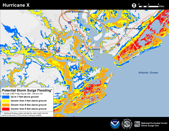
 Experimental Product for 2014
Effective June 1, 2014 and continuing through November 30, 2014,
the NWS is seeking user feedback on experimental Potential Storm
Surge Flooding Map issued by the National Hurricane Center (NHC).
Feedback requested for Experimental Potential Storm Surge Flooding Map in 2014


The Many Factors that Influence Storm Surge
  • Central Pressure
  • Storm Intensity
  • Storm Forward Speed
  • Size
  • Angle of Approach to Coast
  • Shape of the Coastline
  • Width and Slope of Ocean Bottom
  • Local Features

Download INTRODUCTION TO STORM SURGE (PDF) for more background information about storm surges and consult the following links for animations and other useful information. Be sure to watch the PSA video below as well.  

  RELATED INFORMATION
For those in danger areas, it is wise to plan in advance of hurricane season.   Be sure you know areas that would be safe when a storm approaches.   You should be able to get to these safe zones quickly so that you don't risk being trapped by road congestion.

Hurricanes usually provide advance warning.  When local officials recommend evacuation, heed their warnings and put your plan into action.   Structures can be replaced, but lives cannot.

We'll continue our Hurricane Preparedness Week coverage by looking at additional hazards next.   Consult the NHC and other websites for additional information about storm surges.


Monday, May 27, 2013

Hurricane Preparedness 2013 - Storm Surge

Hurricane Storm Surge
Second In the 2013 Series
2013 National Hurricane Preparedness Week

Storm Surge Hazard

We continue our coverage of the 2013 Hurricane Preparedness Week by looking at some of the hurricane hazards.  In particular, we'll start by examining the greatest potential for loss of life related to a hurricane, the storm surge.

Simply put, it is a dome of water that is pushed toward the shore by the force of the winds swirling around the storm.  The advancing water, combined with the normal tides, can increase the mean water level by 15 feet or more.  The threat is increased if it combines with high tide.  Along the Atlantic and Gulf coasts of the United States, the mean sea level is around 10 feet, so a storm surge above that level could cause catastrophic damage.


The Many Factors that Influence Storm Surge
  • Central Pressure
  • Storm Intensity
  • Storm Forward Speed
  • Size
  • Angle of Approach to Coast
  • Shape of the Coastline
  • Width and Slope of Ocean Bottom
  • Local Features


Download INTRODUCTION TO STORM SURGE (PDF) for more background information about storm surges and consult the following links for animations and other useful information. Be sure to watch the PSA video below as well.  

  RELATED INFORMATION

Hurricane track forecasting continues to improve, but the the average track error 48 hours prior to landfall for the Atlantic basin is still considerable.  The 24-hour to 48-hour window is often critical for decision-making. It is important not to focus solely on one storm surge product within this window. Storm specific uncertainties are accounted for in the probabilistic storm surge (p-surge) product, while the *MOMs and *MEOWs provide a worst case storm surge estimate at a regional level.  More


For those in danger areas, it is wise to plan in advance of hurricane season.   Be sure you know areas that would be safe when a storm approaches.   You should be able to get to these safe zones quickly so that you don't risk being trapped by road congestion.

Hurricanes usually provide advance warning.  When local officials recommend evacuation, heed their warnings and put your plan into action.   Structures can be replaced, but lives cannot.

We'll continue our Hurricane Preparedness Week coverage by looking at additional hazards next.   Consult the NHC and other websites for additional information about storm surges.


Wednesday, November 9, 2011

Epic Storm Bearing Down on Alaska


Hurricane-force Winds 
Heavy Snowfall 
Coastal Flooding & Severe Erosion

NOAA is predicting a major Bering Sea Storm bearing down on Western Alaska with a mix of strong winds, high seas, blizzard conditions and major coastal flooding. Warnings and forecasts for Western and Northwest Alaska can be found here. Warnings and forecasts for the Aleutian & Pribilof Islands here and Southwest Alaska can be found here. An additional resource for total water level estimations for some western Alaska communities can be found here. (11/08/11)

  ...Life-Threatening Epic Storm Continues to Impact Western Alaska Coast This Morning...
Published (NWS): Wed, 09 Nov 2011 08:16:35 EST

A powerful and extremely dangerous storm of near-record magnitude is now impacting western Alaska. Impacts will spread northwest and continue through Thursday in some communities. Coastal Flood and Blizzard Warnings are in effect for most of the Alaska’s west and northwest coasts. At 3:00 a.m. EST (11:00 p.m. AKST) the center of the low pressure system was located about 100 miles west of St. Lawrence Island in the Bering Sea, with a minimum central pressure of 943 mb (27.85 inches). This is one of the deepest systems in recent history to move through the Bering Sea. The storm is expected to move north-northeast this morning, as conditions worsen, creating a life-threatening situation for a large portion of the western Alaska coast today, especially in the Seward Peninsula near Nome, which is getting hit hard by blizzard conditions and 70 mph winds, along with 8 foot coastal storm surge.

Lack of Sea Ice Problematic

Arctic sea ice this year reached the second-lowest coverage since satellite records began in 1979, according to the National Snow and Ice Data Center in Boulder, Colorado. While powerful storms in the North Pacific and Bering Sea are common for this time of year, this storm is unusual because it is going farther north.   Also, without the cover of sea ice, Alaska's coast will feel the full brunt of the 6 to 9 foot storm surge.

Be Prepared for
Winter Storms & Extreme Cold 

Federal, state and local agencies were making emergency preparations in advance of the storm.

Monday, May 23, 2011

Hurricane Preparedness 2011 - Storm Surge & Marine Safety

NOAA Storm Surge Products
Hurricane Storm Surge & Marine Safety
Second In the 2011 Series

Storm Surge Hazard

We continue our coverage of the 2011 Hurricane Preparedness Week by looking at some of the hurricane hazards.  In particular, we'll start by examining the greatest potential for loss of life related to a hurricane, the storm surge.

Simply put, it is a dome of water that is pushed toward the shore by the force of the winds swirling around the storm.  The advancing water, combined with the normal tides, can increase the mean water level by 15 feet or more.  The threat is increased if it combines with high tide.  Along the Atlantic and Gulf coasts of the United States, the mean sea level is around 10 feet, so a storm surge above that level could cause catastrophic damage.


RELATED INFORMATION

Hurricane track forecasting continues to improve, but the the average track error 48 hours prior to landfall for the Atlantic basin is still considerable.  The 24-hour to 48-hour window is often critical for decision-making. It is important not to focus solely on one storm surge product within this window. Storm specific uncertainties are accounted for in the probabilistic storm surge (p-surge) product, while the *MOMs and *MEOWs provide a worst case storm surge estimate at a regional level.  More


Marine Safety

Hurricanes have been the cause of many maritime disasters and unfortunately, there is no single rule of thumb that can be used by mariners to ensure safe separation from a hurricane at sea. Instead, constant monitoring of hurricane potential & continual risk analysis when used with some fundamental guidelines become the basic tools to minimize a hurricane's impact to vessels at sea or in port.

Marine safety isn't just for the small private boater,  the "big boys" need to pay attention here too. Cruise lines constantly monitor sea conditions as well as weather conditions, such as approaching tropical storms, both on the ship and in their headquarters offices.   The decisions they make are also coordinated with local and federal agencies such as NOAA's NHC and the local NWS office.

Ship Versus Hurricane Track Analysis
In the dynamic state of moving ships & hurricanes, recurring comparison of hurricane forecast track versus planned ship movement is mandatory. The continual monitoring of the latest official NHC forecasts compared to current or planned evasion options can greatly increase a mariner's confidence regarding vessel safety.  
Read More about Marine Safety.

RELATED INFORMATION


RELATED MULTIMEDIA

We will continue coverage of Hurricane Preparedness Week by looking at high winds and tornado hazards tomorrow. Additional Hurricane information can be found in our static Weather tab.