Showing posts with label itinerary change. Show all posts

Monday, June 1, 2015

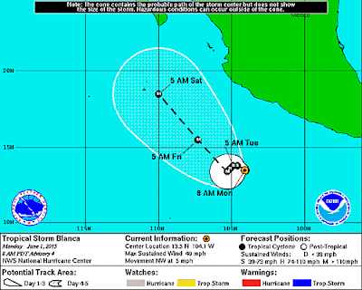
Blanca is Second Tropical Storm in East Pacific

TS BLANCA
Other images: 5-Day track off3-Day track off3-Day track onInteractive

HURRICANE BLANCA
Tropical Depression Two-E formed Sunday, well south of southwest Mexico.  It has already become the second tropical storm of  the East Pacific 2015 Hurricane Season and it is expected to grow in strength quickly becoming the second hurricane.

Blanca is a category 4 hurricane on the Saffir-Simpson Hurricane Wind Scale.

NHC issuing advisories on Hurricane BLANCA
(June 1) 

The National Hurricane Center is issuing advisories on category 4
Hurricane Andres, located several hundred miles southwest of the
southern tip of the Baja California peninsula, and on Tropical
Storm Blanca, located a few hundred miles south-southwest of
Zihuatanejo, Mexico.


Full coverage of this, and all tropical storms, can be found on our Hurricane Zone page.   There are RSS feeds from the National Hurricane Center posted there giving you up to the minute information.   For storms that impact cruises, we will bring you information on those details as well.  Please bookmark that page for further reference during the Hurricane Season which runs now through November 30th.


HURRICANE BLANCA ...BLANCA WEAKENS TO A DEPRESSION...
WIND:
near 140 mph (220 km/h) with higher
gusts
WATCHES/ WARNINGS:
...ALL WATCHES AND WARNINGS DISCONTINUED...
 
A Hurricane Watch is in effect for...
* Cabo San Lucas to Santa Fe

A Tropical Storm Warning is in effect for...
* Loreto to Puerto San Andresito, including Cabo San Lucas

A Tropical Storm Watch is in effect for...
* North of Puerto San Andresito to Punta Abreojos
* North of Loreto to Mulege
SHIP IMPACT:
 Carnival Miracle altered itinerary
traded a sea day for a call on Ensenada on Sunday
changed Monday's overnight in Cabo San Lucas to Wednesday
cancelled call to Puerto Vallarta on Wednesday 
     
A Tropical Storm Warning means that tropical storm conditions are
expected somewhere within the warning area within 36 hours.

A Tropical Storm Watch means that tropical storm conditions are
possible within the watch area, generally within 48 hours.

Storm Archive       Graphics Archive


MORE INFORMATION ABOUT HURRICANES (CLICK HERE)

HAZARDS AFFECTING LAND

SURF:  Swells generated by Blanca will begin affecting portions of
the coast of southwestern Mexico during the next couple of days.
These swells are likely to cause life-threatening surf and rip
current conditions.  Please consult products from your local weather
office.
HISTORICAL STORM NOTES 
 

530 PM CDT SUN MAY 31 2015

...NEW TROPICAL DEPRESSION FORMS WELL SOUTH OF SOUTHWESTERN
MEXICO...
 
1000 AM CDT MON JUN 01 2015

...TROPICAL STORM BLANCA FORMS...
...EXPECTED TO STRENGTHEN QUICKLY...
 
400 PM CDT TUE JUN 02 2015

...BLANCA BECOMES A HURRICANE...
...FURTHER STRENGTHENING EXPECTED...
 
1000 AM CDT WED JUN 03 2015

...BLANCA REACHES 130 MPH WINDS...
 
300 PM MDT FRI JUN 05 2015

...AIR FORCE HURRICANE HUNTER PLANE FINDS BLANCA WITH 90-MPH
WINDS...
The Government of Mexico has issued a Tropical Storm Watch for the
southern Baja California peninsula from La Paz to Santa Fe,
including Cabo San Lucas.
 
 
300 PM MDT MON JUN 08 2015

...BLANCA WEAKENS TO A DEPRESSION...
...ALL WATCHES AND WARNINGS DISCONTINUED... 

Thursday, July 31, 2014

Tropical Storm Bertha 2nd in Atlantic Season


Tropical Storm BERTHA

Tropical Storm BERTHA

Air Force Reserve reconnaissance aircraft this afternoon and evening investigated the well-defined low pressure system located about 350 miles east-southeast of Barbados. Surface winds were measured between 40 and 45 MPH prompting Tropical Storm Watches and Warnings for several countries in the immediate path of the storm. Showers and thunderstorms, along with gale-force winds are expected in the area through Friday and additional warnings may be necessary. The storm is expected to track towards the Bahamas by early next week. We will continue to monitor this storm as it may be necessary to alter cruise ship itineraries depending on the strengthening of the storm.

(8/5) MAXIMUM SUSTAINED WINDS ARE NEAR 50 MPH...85 KM/H...WITH HIGHER
GUSTS.  SLOW WEAKENING IS FORECAST DURING THE NEXT 48 HOURS...AND
BERTHA IS LIKELY TO BECOME A POST-TROPICAL OR EXTRATROPICAL CYCLONE
ON WEDNESDAY.

 
NHC issuing advisories on TS BERTHA and TS JULIO


Full coverage of this, and all tropical storms, can be found on our Hurricane Zone page.   There are RSS feeds from the National Hurricane Center posted there giving you up to the minute information.   For storms that impact cruises, we will bring you information on those details as well.  Please bookmark that page for further reference during the Hurricane Season which runs now through November 30th.

Tropical Storm BERTHA
500 PM EDT TUE AUG 05 2014

...BERTHA MOVING NORTH-NORTHEASTWARD WELL OFFSHORE OF THE
U.S. MID-ATLANTIC COAST...

WIND:
NEAR 50 MPH...85 KM/H...WITH HIGHER
GUSTS
WATCHES/ WARNINGS:
SUMMARY OF WATCHES AND WARNINGS IN EFFECT...

THERE ARE NO COASTAL WATCHES OR WARNINGS IN EFFECT.
SHIP IMPACT:
 
No Further Cruise Ship Impact
     
Storm Archive       Graphics Archive

A TROPICAL STORM WARNING MEANS THAT TROPICAL STORM CONDITIONS ARE
EXPECTED SOMEWHERE WITHIN THE WARNING AREA...IN THIS CASE WITHIN
THE NEXT 12 TO 24 HOURS.

A TROPICAL STORM WATCH MEANS THAT TROPICAL STORM CONDITIONS ARE
POSSIBLE WITHIN THE WATCH AREA...IN THIS CASE WITHIN 24 TO 36
HOURS.


HAZARDS AFFECTING LAND 
 
WIND...TROPICAL STORM CONDITIONS ARE EXPECTED IN PORTIONS OF THE
SOUTHEASTERN BAHAMAS AND THE TURKS AND CAICOS ISLANDS OVER THE NEXT
FEW HOURS.

RAINFALL...BERTHA IS EXPECTED TO PRODUCE RAINFALL AMOUNTS OF 1 TO 3
INCHES WITH ISOLATED AMOUNTS UP TO 5 INCHES ACROSS EASTERN PORTIONS
OF THE DOMINICAN REPUBLIC AS WELL THE TURKS AND CAICOS THROUGH
MONDAY.

Historical Notes:

1100 PM AST THU JUL 31 2014

...TROPICAL STORM BERTHA DEVELOPS EAST OF THE SOUTHERN LESSER
ANTILLES...
...TROPICAL STORM WARNINGS AND WATCHES ISSUED...
 
200 AM AST SAT AUG 02 2014

...BERTHA RACING WEST-NORTHWESTWARD ACROSS THE NORTHEASTERN
CARIBBEAN SEA...
 
200 PM EDT SUN AUG 03 2014

...BERTHA MOVING NEAR THE SOUTHEASTERN BAHAMAS...
 
A TROPICAL STORM WARNING IS IN EFFECT FOR...
* THE SOUTHEASTERN BAHAMAS...INCLUDING THE ACKLINS...CROOKED
ISLAND...LONG CAY...THE INAGUAS...MAYAGUANA...AND THE RAGGED ISLANDS
* THE TURKS AND CAICOS ISLANDS
 
Carnival Breeze, Carnival Liberty and Carnival Valor 
itineraries were impacted by TS Bertha. 


Tuesday, July 1, 2014

Arthur is First Tropical Storm in Atlantic 2014 Season

Hurricane ARTHUR
NHC issuing advisories on Hurricane ARTHUR and TS DOUGLAS
NHC News: Go “Inside the Eye” as we explain our new 5-day Graphical Tropical Weather Outlook making its debut July 1st:  
 
Looks like it's going to be an active 4th of July holiday weekend with three storms being tracked by the National Hurricane Center.  The 2014 Atlantic Hurricane Season has finally had the first tropical depression form and increase to Tropical Storm Arthur.  The storm formed offshore the central Florida Atlantic coast.  It will continue northward along the coast and strengthen into a hurricane before continuing on to Canada.


Full coverage of this, and all tropical storms, can be found on our Hurricane Zone page.   There are RSS feeds from the National Hurricane Center posted there giving you up to the minute information.   For storms that impact cruises, we will bring you information on those details as well.  Please bookmark that page for further reference during the Hurricane Season which runs now through November 30th.

Tropical Storm ARTHUR
1100 AM EDT TUE JUL 01 2014

...DEPRESSION BECOMES A TROPICAL STORM 
OFFSHORE OF THE CENTRAL
FLORIDA ATLANTIC COAST...
WIND:
NEAR 90 MPH...150 KM/H...WITH HIGHER
GUSTS.
WATCHES/ WARNINGS:
A HURRICANE WARNING IS IN EFFECT FOR...
* OCRACOKE INLET NORTH CAROLINA TO THE NORTH CAROLINA/VIRGINIA
BORDER
* EASTERN ALBEMARLE SOUND

A TROPICAL STORM WARNING IS IN EFFECT FOR...
* THE NORTH CAROLINA/VIRGINIA BORDER TO CAPE CHARLES LIGHT
VIRGINIA...INCLUDING THE MOUTH OF THE CHESAPEAKE BAY
* WESTERN ALBEMARLE SOUND
* NANTUCKET
* CAPE COD FROM PROVINCETOWN TO WOODS HOLE
* DIGBY TO PORTERS LAKE NOVA SCOTIA

A TROPICAL STORM WATCH IS IN EFFECT FOR...
* NEW BRUNSWICK FROM THE U. S./CANADA BORDER TO GRAND-ANSE
* NOVA SCOTIA NORTH OF DIGBY...NORTH OF PORTERS LAKE...AND INCLUDING
CAPE BRETON ISLAND
* ALL OF PRINCE EDWARD ISLAND
 
INTERESTS ELSEWHERE IN COASTAL PORTIONS OF NEW ENGLAND...NEW
BRUNSWICK...AND NEWFOUNDLAND SHOULD MONITOR THE PROGRESS OF ARTHUR. 
SHIP IMPACT:
 Carnival Splendor -- as it makes its way 
up the East Coast of the US. 
The Carnival cruise ship will call in at Bermuda 
rather than St John tomorrow (July 5th).
     
Storm Archive       Graphics Archive

A TROPICAL STORM WATCH MEANS THAT TROPICAL STORM CONDITIONS ARE
POSSIBLE WITHIN THE WATCH AREA...IN THIS CASE WITHIN 24 TO 36 HOURS. 


HAZARDS AFFECTING LAND

WIND...TROPICAL STORM CONDITIONS WILL CONTINUE IN PORTIONS OF THE
WARNING AREAS IN NORTH CAROLINA AND VIRGINIA THIS MORNING. TROPICAL
STORM CONDITIONS ARE EXPECTED TO REACH THE WARNING AREA IN NEW
ENGLAND BY TONIGHT.

STORM SURGE...THE COMBINATION OF A DANGEROUS STORM SURGE AND THE
TIDE WILL CAUSE NORMALLY DRY AREAS NEAR THE COAST TO BE FLOODED BY
RISING WATERS. THE WATER COULD REACH THE FOLLOWING HEIGHTS ABOVE
GROUND IF THE PEAK SURGE OCCURS AT THE TIME OF HIGH TIDE...

NORTH CAROLINA WITHIN THE HURRICANE WARNING AREA...3 TO 5 FT
PAMLICO AND ALBEMARLE SOUNDS...2 TO 4 FT
EXTREME SOUTHEASTERN VIRGINIA...1 TO 3 FT

COASTAL FLOODING IS ALSO POSSIBLE ALONG CAPE COD.

THE HIGHEST WATER WILL OCCUR ALONG THE IMMEDIATE COAST IN AREAS OF
ONSHORE FLOW. THE SURGE WILL BE ACCOMPANIED BY LARGE AND DAMAGING
WAVES. SURGE-RELATED FLOODING DEPENDS ON THE RELATIVE TIMING OF THE
SURGE AND THE TIDAL CYCLE...AND CAN VARY GREATLY OVER SHORT
DISTANCES. FOR INFORMATION SPECIFIC TO YOUR AREA...PLEASE SEE
PRODUCTS ISSUED BY YOUR LOCAL NATIONAL WEATHER SERVICE OFFICE AND
THE NEW EXPERIMENTAL POTENTIAL STORM SURGE FLOODING MAP FOR MORE
DETAILS.

RAINFALL...RAINFALL WILL BE DIMINISHING OVER EASTERN NORTH CAROLINA
THIS MORNING WITH STORM TOTAL ACCUMULATIONS OF 4 TO 6 INCHES AND
ISOLATED MAXIMUM OF 8 INCHES POSSIBLE. RAINFALL TOTALS OF 1 TO 2
INCHES ARE POSSIBLE OVER SOUTHEASTERN VIRGINIA. RAINFALL
ACCUMULATIONS OF 2 TO 4 INCHES ARE POSSIBLE ACROSS RHODE
ISLAND...EASTERN MASSACHUSETTS AND COASTAL MAINE.

SURF...SWELLS GENERATED BY ARTHUR ARE AFFECTING AREAS ALONG THE
COAST OF NORTH CAROLINA...AND WILL SPREAD NORTHWARD ALONG THE
MID-ATLANTIC AND NORTHEAST COASTS OF THE UNITED STATES TODAY. THESE
SWELLS ARE EXPECTED TO CAUSE LIFE-THREATENING SURF AND RIP CURRENTS.
FOR MORE INFORMATION...PLEASE MONITOR PRODUCTS ISSUED BY YOUR LOCAL
NATIONAL WEATHER SERVICE FORECAST OFFICE.


Historical Notes:

1100 AM EDT TUE JUL 01 2014

...DEPRESSION BECOMES A TROPICAL STORM OFFSHORE OF THE CENTRAL
FLORIDA ATLANTIC COAST... 
 
 500 AM EDT THU JUL 03 2014

...ARTHUR NOW A HURRICANE...
...EXPECTED TO MOVE NEAR THE NORTH CAROLINA OUTER BANKS TONIGHT...
 
800 PM EDT THU JUL 03 2014

...8 PM POSITION UPDATE...
...EYE OF ARTHUR PASSING SOUTHEAST OF WILMINGTON NORTH CAROLINA...
 
100 AM EDT FRI JUL 04 2014

...EYE OF ARTHUR MOVING OVER SOUTHERN PAMLICO SOUND...
...HURRICANE CONDITIONS SPREADING NORTHWARD ALONG THE OUTER BANKS...
 
900 AM EDT FRI JUL 04 2014

...ARTHUR BEGINS TO WEAKEN AS IT PULLS AWAY FROM NORTH CAROLINA...