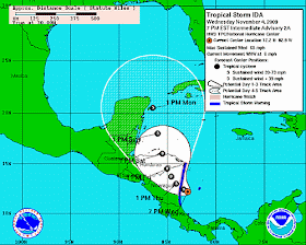
Tropical Storm Ida
Another tropical storm has formed in the Atlantic Ocean and is currently east of Nicaragua. Hurricane Watches and Tropical storm watches have been posted. This storm quickly became a hurricane, but fortunately has now weakened. The forecast is for Ida to restrengthen as it continues along its projected path.
As a service to my clients and my blog readers, we'll provided continual updates on tropical storms and any cruise line advisories that are posted. For convenience, RSS feeds are also added so that you can get up-to-date information between posts. <NHC Active Storms>
UPDATE: 1000 PM EST SAT NOV 07 2009... IDA MOVING NORTH-NORTHWESTWARD STILL AS A TROPICAL STORM... IDA IS MOVING TOWARD THE NORTH-NORTHWEST NEAR 12 MPH... 19 KM/HR... AND THIS GENERAL HEADING WITH AN INCREASE IN FORWARD SPEED IS EXPECTED OVER THE NEXT 48 HOURS. ON THE FORECAST TRACK... IDA IS EXPECTED TO MOVE THROUGH THE YUCATAN CHANNEL AND INTO THE SOUTHEASTERN GULF OF MEXICO ON SUNDAY.
MAXIMUM SUSTAINED WINDS ARE NEAR 70 MPH...110 KM/HR...WITH HIGHER GUSTS. IDA IS FORECAST TO BECOME A HURRICANE LATER TONIGHT OR ON SUNDAY.
IDA IS EXPECTED TO PRODUCE TOTAL RAIN ACCUMULATIONS OF 3 TO 5 INCHES OVER PORTIONS OF THE YUCATAN PENINSULA AND WESTERN CUBA...WITH POSSIBLE ISOLATED MAXIMUM AMOUNTS OF 10 INCHES. RAINFALL AMOUNTS OF 1 TO 2 INCHES ARE ALSO POSSIBLE ACROSS THE CAYMAN ISLANDS...
A HURRICANE WATCH REMAINS IN EFFECT FOR THE YUCATAN PENINSULA OF MEXICO FROM TULUM TO CABO CATOCHE.
A HURRICANE WATCH MEANS THAT HURRICANE CONDITIONS ARE POSSIBLE WITHIN THE WATCH AREA... GENERALLY WITHIN 36 HOURS.
A TROPICAL STORM WARNING REMAINS IN EFFECT FOR GRAND CAYMAN ISLAND... A TROPICAL STORM WARNING ALSO REMAINS IN EFFECT FOR THE YUCATAN PENINSULA OF MEXICO FROM PUNTA ALLEN NORTHWARD TO SAN FELIPE... A TROPICAL STORM WATCH IS IN EFFECT FOR THE ISLE OF YOUTH.
A TROPICAL STORM WATCH MEANS THAT TROPICAL STORM CONDITIONS ARE POSSIBLE WITHIN THE WATCH AREA... GENERALLY WITHIN 36 HOURS.
A TROPICAL STORM WARNING MEANS THAT TROPICAL STORM CONDITIONS ARE EXPECTED SOMEWHERE WITHIN THE WARNING AREA WITHIN 24 HOURS.
This post will track Tropical Storm Ida until it is no longer tracked by the NHC.
Local Weather Statements
Cruise Ship Tropical Storm
Updates / Itinerary Changes
The following are links to the most recent advisory posted by the respective cruise line. As we learn of changes, this post will be updated.
This storm isn't as predictable as others so far this hurricane season. As you can see from the real-time tracking link below, there are a number of ships in the area that could be affected by Ida depending on the track it takes over the next few days.
PRINCESS CRUISES: Crown Princess (Nov 6, 2009)
Crown Princess will be rearranging the port calls on its November 7 itinerary to avoid Tropical Storm Ida. The ship will depart Fort Lauderdale as scheduled, and the new cruise itinerary will be as follows: Princess Cays; sea day; Grand Cayman; Roatan, Honduras; Cozumel, Mexico; sea day; return to Fort Lauderdale.
Live Cruise Ship and Ocean Liner Tracking:
<Interactive tracking map> See where ships are relative to tropical storms.
Cruise lines will do everything to keep passengers and crew safe. A cruise is rarely cancelled because of weather, even hurricanes. The cruise lines monitor progress of any storms both in their main offices and onboard the vessels. They work closely with the various weather services, such as NOAA and NHC, to make determinations about itinerary deviations.
Continue to watch this post, I will provide updates as conditions change. If you are on a cruise this week in the area, be sure to monitor the storm closely.


No comments:
Post a Comment