 | ||
| Hurricane Matthew courtesy NOAA NHC |
HURRICANE MATTHEW

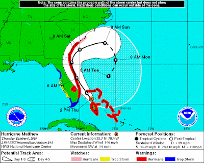
| Hurricane Matthew | 1200 PM EDT FRI OCT 07 2016 ...12 PM EDT POSITION UPDATE... ...MATTHEW'S WESTERN EYEWALL CONTINUES TO BRUSH THE COAST OF NORTHEAST FLORIDA... |
| WIND: | MAXIMUM SUSTAINED WINDS...120 MPH...195 KM/H |
| WATCHES/ WARNINGS: | SUMMARY OF WATCHES AND WARNINGS IN EFFECT... A Hurricane Warning is in effect for... * Cocoa Beach to Surf City A Hurricane Watch is in effect for... * North of Surf City to Cape Lookout A Tropical Storm Warning is in effect for... * Sebastian Inlet to Cocoa Beach * North of Surf City to Duck * Pamlico and Albemarle Sounds Interests elsewhere in the Florida Peninsula, the Florida Keys, and in the Carolinas should monitor the progress of Matthew. |
| SHIP IMPACT: | Carnival Cruise Line
Disney Cruise Line
Royal Caribbean
Norwegian Cruise Line
|
Storm Archive Graphics Archive
A TROPICAL STORM WARNING MEANS THAT TROPICAL STORM CONDITIONS ARE
EXPECTED SOMEWHERE WITHIN THE WARNING AREA...IN THIS CASE WITHIN
THE NEXT 12 TO 24 HOURS.

A TROPICAL STORM WATCH MEANS THAT TROPICAL STORM CONDITIONS ARE
POSSIBLE WITHIN THE WATCH AREA...IN THIS CASE WITHIN 24 TO 36
HOURS.
We just returned from Disney's Walt Disney World which celebrated it's 45th Anniversary on October 1, 2016. Since opening it's doors in 1971, the park has only been closed three times in anticipation of hurricanes: Hurricane Floyd (September, 1999), Hurricane Frances (September, 2004) and Hurricane Jeanne (September, 2005).
A spokeswoman for Walt Disney World said, "Based on the most recent forecasts for Hurricane Matthew, Walt Disney World theme parks, water parks, Disney Springs, miniature golf courses and ESPN Wide World of Sports Complex will all be closed today (Thursday October 6th) by 5 PM., and will remain closed through Friday, October 7."
Starting October 5th, WDW started warning its guests of possible disruptions due to the approaching hurricane. They also moved guests staying at Fort Wilderness campgrounds.
Here is the latest list of closures / cancellations in the Orlando area:
Thursday - Blizzard Beach, Fort Wilderness campground closed. SeaWorld closes at 2pm. Walt Disney World and Universal Orlando close at 5pm. Halloween Horror Nights, Mickey's Not So Scary Halloween Party and Spirit of Aloha dinner show canceled.
Friday - Walt Disney World, Universal Orlando, SeaWorld, Legoland, Blizzard Beach, Typhoon Lagoon and Fort Wilderness closed. Halloween Horror Nights, Mickey's Not So Scary Halloween Party and Spirit of Aloha dinner show canceled.
Useful Links
Hurricane Matthew Precautions | FAQ | Walt Disney World Resort
Hurricane Matthew to bring severe storm to Walt Disney World | The Disney Blog
NHC issuing advisories for the Atlantic on Hurricane MATTHEW and Hurricane NICOLE
Audio podcasts regarding Matthew now available
#HurricanePrep Mini-Series

HAZARDS AFFECTING LAND
----------------------
WIND:  Hurricane and tropical storm conditions are expected to
continue over the warning area in Florida today, and spread
northward within the warning area through Saturday.

Residents in high-rise buildings should be aware that the winds at
the top of a 30-story building will be, on average, about one
Saffir-Simpson category higher than the winds near the surface.

Tropical storm conditions are expected to first reach the
tropical storm warning area in North Carolina on Saturday morning.

STORM SURGE:  The combination of a dangerous storm surge, the tide,
and large and destructive waves will cause normally dry areas near
the coast to be flooded by rising waters moving inland from the
shoreline.  The water could reach the following heights above ground
if the peak surge occurs at the time of high tide...

Flagler Beach, Florida, to Edisto Beach, South Carolina, including
portions of the St. Johns River...6 to 9 ft
Cocoa Beach to Flagler Beach, Florida...4 to 6 ft
Edisto Beach, South Carolina to Cape Fear, North Carolina...
4 to 6 ft
Sebastian Inlet to Cocoa Beach, Florida...2 to 4 ft
Cape Fear to Salvo, North Carolina, including portions of the
Pamlico and Albemarle Sounds...2 to 4 ft

The deepest water will occur along the immediate coast in areas of
onshore winds.  Surge-related flooding depends on the relative
timing of the surge and the tidal cycle, and can vary greatly over
short distances.  Large waves generated by Matthew will cause water
rises to occur well in advance of and well away from the track of
the center.  For information specific to your area, please see
products issued by your local National Weather Service forecast
office.

There is a danger of life-threatening inundation during the next 36
hours along the Florida northeast coast, the Georgia coast, the
South Carolina coast, and the North Carolina coast from Sebastian
Inlet, Florida, to Cape Fear, North Carolina.  There is the
possibility of life-threatening inundation during the next 48 hours
from north of Cape Fear to Salvo, North Carolina. For a depiction of
areas at risk, please see the Prototype National Weather Service
Storm Surge Watch/Warning Graphic. For information specific to your
area, please see products issued by your local National Weather
Service forecast office.

The Prototype Storm Surge Watch/Warning Graphic is a depiction of
areas that would qualify for inclusion under a storm surge watch or
warning currently under development by the National Weather Service
and planned for operational use in 2017.  The Prototype Graphic is
available at hurricanes.gov.

RAINFALL: Matthew is expected to produce total rain accumulations of
8 to 12 inches over the Atlantic coast of the United States from
central Florida to eastern North Carolina...with possible isolated
maximum amounts of 15 inches. This rainfall may result in flooding
and flash flooding.

TORNADOES:  An isolated tornado or two is possible along the South
Carolina, Georgia, and northeast Florida coasts today.

SURF:  Swells generated by Matthew will continue to affect portions
of the Bahamas and the east coast of Florida during the next few
days, and will spread northward along the southeast U.S. coast
through the weekend.  These swells will likely cause
life-threatening surf and rip current conditions. Please consult
products from your local weather office.
No comments:
Post a Comment