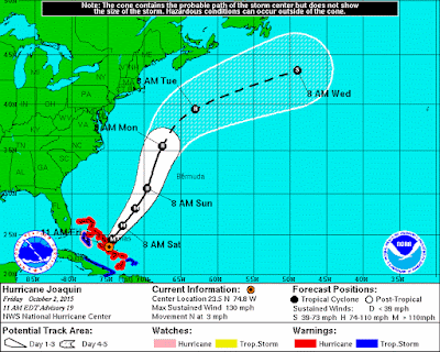
A turn toward the northeast is expected tonight with an additional increase in forward speed. On the forecast track, the core of the strongest winds of Joaquin will continue moving over portions of the central and northwestern Bahamas today. Joaquin will begin to move away from the Bahamas tonight and Saturday. Carnival, Disney, Norwegian, and Royal Caribbean Cruise Lines have all been impacted by the hurricane. Please click on the following links for updated information.
Carnival: Tropical Weather Update (Joaquin)
Norwegian: Weather Alert
Royal Caribbean: Tropical Weather Updates
NHC issuing advisories for the Atlantic on Hurricane JOAQUIN
Full coverage of this, and all tropical storms, can be found on our Hurricane Zone page. There are RSS feeds from the National Hurricane Center posted there giving you up to the minute information. For storms that impact cruises, we will bring you information on those details as well. Please bookmark that page for further reference during the Hurricane Season which runs now through November 30th.
| HURRICANE JOAQUIN |
200 PM AST SUN OCT 04 2015 ...EYE OF JOAQUIN PASSING JUST TO THE SOUTHWEST OF BERMUDA... ...TROPICAL-STORM-FORCE WINDS LASHING THE ISLAND... |
| WIND: | 105 MPH...165 KM/H with higher gusts |
| WATCHES/ WARNINGS: | A Hurricane Warning is in effect for... * Bermuda |
| SHIP IMPACT: | Carnival Pride: Pride's September 30 itinerary from Baltimore will replace its October 1 call at Half Moon Cay with a sea day. Carnival Valor: Valor's September 26 cruise from Port Canaveral will miss Grand Turk on October 1 and instead spend a day at sea. Carnival Conquest: The ship's September 26 itinerary will replace Grand Turk on October 2 with a sea day. Carnival Sensation: Carnival Sensation's three-night Bahamas cruise (Oct 1 sailing) will visit Freeport instead of Nassau on October 2. Disney Magic: Disney Magic has been forced to skip its scheduled visits to Castaway Cay and Nassau. The ship's new itinerary is Key West on October 1, Cozumel on October 2 and a sea day on October 3. Disney Dream: Disney Dream will replace its October 2 call at Nassau with a sea day. As of now, it will visit Castaway Cay on October 3 as scheduled. Disney Fantasy: Disney Fantasy will skip Castaway Cay on October 2 before returning to Port Canaveral on Saturday. Norwegian Getaway: On October 2, Norwegian Getaway will skip Nassau for a sea day before returning to Miami Saturday morning. Royal Princess: Royal Princess will skip the line's private island on September 30 and October 2. Crystal Symphony: The ship has canceled its Bar Harbor call, scheduled for October 2. It will arrive in New York October 3 (a day earlier than scheduled), giving passengers more time in the city. Liberty of the Seas: The Royal Caribbean ship will head to St. John, Canada on Saturday instead of King Wharf, Bermuda. Enchantment of the Seas: Royal Caribbean's Enchantment of the Seas will not be able to call on Nassau, Bahamas as originally scheduled. Instead, the ship will sail to Freeport, Bahamas in an effort to try to find the calmest seas possible. |
A Hurricane Warning means that hurricane conditions are expected
somewhere within the warning area.

A Hurricane Watch means that hurricane conditions are possible
within the watch area.
A Tropical Storm Warning means that tropical storm conditions are
expected somewhere within the warning area within 36 hours.

A Tropical Storm Watch means that tropical storm conditions are
possible within the watch area, generally within 48 hours.
Storm Archive Graphics Archive
MORE INFORMATION ABOUT HURRICANES (CLICK HERE)
HISTORICAL NOTES
HAZARDS AFFECTING LAND
WIND:  Tropical storm conditions are first expected to reach Bermuda
later this morning, with hurricane conditions expected by later this
afternoon and early evening.

TORNADOES:  Isolated tornadoes are possible on Bermuda this
afternoon and early evening.

STORM SURGE:  A dangerous and life-threatening storm surge is
expected to produce significant coastal flooding in Bermuda.  Near
the coast, the surge will be accompanied by large and destructive
waves.

RAINFALL:  Joaquin is expected to produce total rainfall
accumulations of 3 to 5 inches across Bermuda through tonight.

SURF:  Swells generated by Joaquin will continue to affect portions
of the Bahamas during the next few days. Swells are affecting much
of the southeastern and mid-Atlantic coasts of the United States and
will spread northward along the east coast of the United States
through Monday.  These swells are likely to cause life-threatening
surf and rip current conditions. Even though Joaquin is expected to
pass well east of the coast of the United States, a prolonged period
of elevated water levels and large waves will affect the
mid-Atlantic region, causing significant beach and dune erosion with
moderate coastal flooding likely. Please consult products from your
local weather office.
1100 PM AST SUN SEP 27 2015
...NEW TROPICAL DEPRESSION FORMS IN THE WESTERN ATLANTIC...
1100 PM EDT MON SEP 28 2015
...DEPRESSION STRENGTHENS TO TROPICAL STORM JOAQUIN...
...THE TENTH NAMED STORM OF THE SEASON...
1100 PM EDT TUE SEP 29 2015
...JOAQUIN EXPECTED TO BECOME A HURRICANE LATER TONIGHT OR
WEDNESDAY...
...HURRICANE WATCH ISSUED FOR THE CENTRAL BAHAMAS...
800 AM EDT WED SEP 30 2015
...JOAQUIN BECOMES A HURRICANE..
1100 PM EDT WED SEP 30 2015
...JOAQUIN BECOMES A CATEGORY 3 HURRICANE AS IT MOVES TOWARD
THE CENTRAL BAHAMAS...
535 AM EDT THU OCT 1 2015
At 535 AM EDT (0935 UTC) the Government of the Bahamas has issued a
Hurricane Warning for the Acklins, Crooked Island, and Mayaguana in
the southeastern Bahamas.
200 PM EDT THU OCT 01 2015
...JOAQUIN BECOMES AN EXTREMELY DANGEROUS CATEGORY 4 HURRICANE...
...CENTRAL BAHAMAS TO EXPERIENCE HURRICANE FORCE WINDS...STORM
SURGE...AND HEAVY RAIN THROUGH TONIGHT...
1100 AM EDT FRI OCT 02 2015
...EXTREMELY DANGEROUS JOAQUIN NOW MOVING NORTHWARD AS IT BATTERS
THE CENTRAL BAHAMAS...
...HURRICANE CONDITIONS TO CONTINUE OVER THE CENTRAL BAHAMAS
TODAY...


No comments:
Post a Comment